In May 1, 2004, the European Union has living the most important enlargement of its history, as well from its scale as from its diversity. It has indeed accomodated ten new countries: Cyprus, Estonia, Hungary, Latvia, Lithuania, Malta, Poland, the Czech Republic, Slovakia and Slovenia.
Europe of the twenty-five was born on paper. Each one of us has to make it exist. This widening remains very abstract in the spirit of much of the citizens. Few Europeans today are able to quote and even less to locate all the Member States.
To contribute to this European construction, satellite imagery constitutes an interesting opportunity to visually illustrate the territorial diversity of the Union. Moreover, and contrary to the political maps, they highlight the elements of relief, hydrography and land use who structure the territory beyond the national borders. They thus make it possible to draw the attention to the elements which link rather than on the limits which divide.

The poster 'The European Union, a novel perspective' was realized on this occasion by the Unité de recherche en environnemétrie et géomatique of the catholic University of Louvain-la-Neuve. It includes a satellite map of Europe based on a year synthesis of VEGETATION data, a sensor onboard the SPOT 4 satellite. There's also a timeline illustrating the various stages of the construction of Europe (from the end of the war to nowadays), as well as a text inviting to a thorough study of the image. The poster was available in French, Dutch and English.
A collective project without precedent
Since its creation, the European Union did not cease gathering countries around a common project based on the values of democracy, peace, development and solidarity.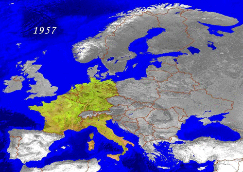
In May 2004, with its ten new Members, the Union has become the largest political entity ever created voluntarily. Several candidate states could join this Europe which will perhaps extend someday from the Atlantic to the Ural.
Committed to a historical process without precedent, the European Union is in the process of giving birth to a new kind of State.
The Union members are gathered around a common cultural heritage in search of political and economic cohesion to speak with a single voice in the concert of the nations.
The diversity of the people, their cultures and their territories constitutes at the same time the greatest challenge and the greatest richness of this new Europe.
The creation and successive adhesions of the UE
- 1957 : the basis of the european construction is laid on 25 March 1957. Signing by the six ECSC signatory countries of the Treaties of Rome , establishing the European Atomic Energy Community (EAEC or Euratom) and the European Economic Community (EEC).
- 1973 : First enlargement of the Community with the adherence of Denmark, Ireland and the United Kingdom; Europe of the Nine.
- 1981 : Greece joins the EEC. Now spoken of as Europe of the Ten.
- 1986 : Birth of Europe of the Twelve when Portugal and Spain join the Community. Ratification of the Single European Act, revising the Treaty of Rome and relaunching European integration.
- 1995 : Birth of Europe of the Fifteen with the adherence of Austria, Finland and Sweden. Entry into force of the Schengen Agreement (elimination of passport control at borders).
- 2004 : 2004 Integration of Cyprus, the Czech Republic, Estonia, Hungary, Latvia, Malta, Poland, Slovakia and Slovenia. EU achieves greatest enlargement in its history and becomes, with its 25 members, the largest political entity formed voluntarily.
Since 2004, 3 new countries have joined the European Union: Romania and Bulgaria in 2007 and Croatia in 2013.
To get into further detail
The European Commission places at your disposal a series of publications (booklets, maps, CDRoms....): http://europa.eu/about-eu/basic-information/index_en.htm
An impressive territorial diversity
The European Union consists of a great number of natural areas of generally reduced size.
Its relief is very diversified and underlined by sharply defined coastlines. Hundreds of islands, of sometimes important surface like Great Britain, Ireland, Corsica, Sardinia, Sicily, Crete and Cyprus, populate seas with very different characteristics.
The northern low depth seas are characterized by frequent storms but facilitate the exploitation of oil as at the North Sea. The Mediterranean and the Black Sea are calm seas which reach great depths.
Northern Europe presents a base of very old rocks separated by the Baltic sea from the large germano-Polish glacial plain. This plain is badly drained and also strewn with lakes.
There is a virtually uninterrupted mountainous chain of 4,000 km going from the Cantabrian mountains through the Pyrenees and the Alps and comprising medium altitude mountains (Massif Central, Vosges, Black Forest,…).
Great rivers form a natural link between vast regions, such as the Danube traversing eight countries and whose banks are home to four capital cities.
Yet, for several thousand years, it is essentially the human presence that has formed this territory, producing a genuine mosaic of landscapes where agricultural plains alternate with pasture land and massive forests, often bordering on hilly regions.
As a whole, the Union enjoys a moderate climate, more oceanic on the west, continental on the center and the east and sub-polar in the north. The Mediterranean basin in the south is marked by a hotter and dry climate.
A densely populated area
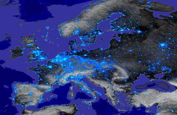
NASA Courtesy (Data : Defense Meteorological Satellite Program - Operational Linescan)
With 7.3% (453 million inhabitants) of the world’s population living in an area corresponding to 3% of its land surface, the European Union is one of the most densely populated regions on the planet.
The rate of urbanization is very high. Eight Europeans out of ten live in towns and one out of three lives in a city with more than one million inhabitants (data 2003).
The night acquisition highlights the most urbanized zones of Europe. The urban network is both dense and unevenly distributed. Certain areas knew an earlier industrial revolution which is today reflected by a dense texture of urban cores.
A major part of the population is concentrated in a large, very high populated arc (1500km long comprising 70 million inhabitants) that links southern England to Lombardy, encompassing the Benelux and the Rhine-Ruhr basin.
The other areas of high population concentration correspond to the capital cities (Paris, Madrid…), coastal regions (Mediterranean, Atlantic coast, Nord Sea), broad valleys (Po plain) and industrial regions (South Poland).