Published on 19 May 2022
The processes deep inside Earth’s core and crust and on its surface are critical to understanding Earth’s system as a whole. Many of ESA’s Earth observation satellites reveal key information about the structure of these internal layers and their interactions with each other and the cryosphere, hydrosphere, atmosphere and ionosphere.
Processes within solid Earth directly impact our environment. Sea-level changes are influenced by surface motions of solid Earth, such as regional ice melt and rebound of Earth’s surface following de-glaciation. In January, the powerful Hunga Tonga eruption served as a painful reminder how the tectonics of Earth’s strong outer layer (lithosphere) can impact our growing population.
Melting sea ice causes land lift
Using ground-breaking space technologies, the Earth Explorer family of research missions have long contributed to monitoring solid Earth. The first Earth Explorer, the Gravity Field and Steady-State Ocean Circulation Explorer (GOCE), used a state-of-the-art gradiometer to form a detailed global model of Earth’s gravity field and geoid.

GOCE satellite
GOCE’s data, now delivered through ESA’s Heritage Space Programme, provide new insights into the physics of Earth’s interior, such as the geodynamics associated with the lithosphere and mantle composition. The data also further our knowledge of Earth’s surface movements, such as land uplift caused by the melting of thick ice sheets. More recently, scientists have combined GOCE data with surface measurements to generate a new model of Earth’s crust and upper mantle.
Swarm maps core dynamics
The swirling, conducting iron in Earth’s liquid outer core create powerful electric currents, which in turn generate a magnetic field stretching far out into space. Earth’s magnetic field and magnetosphere shield life from the high-energy particles in cosmic rays and protect the atmosphere from direct exposure to the solar wind. ESA’s Swarm mission is an operational Earth Explorer tasked with mapping Earth’s magnetic field, studying core dynamics, space weather and radiation hazards.
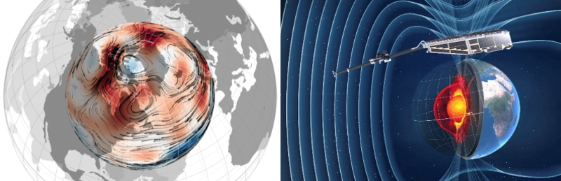
Swarm helps further our understanding of core dynamics by mapping the magnetic waves across the surface of Earth’s outer core.
The 4D-Earth Swarm project aims to map the base state within Earth’s outer core and better understand the core dynamics driving Earth’s dynamo, by examining the rapid changes in the geomagnetic field as recorded by the three Swarm satellites.
Recent research using data from Swarm are also helping improve scientists’ understanding of a large region of reduced magnetic field, known as the ‘South Atlantic Anomaly’. Swarm’s global maps of the magnetic field contribute to research on how the iron in the core moves, helping explain why the north magnetic pole is drifting steadily towards Siberia.
Read the rest of the article
over on ESA's Earth Online website