Context and objectives
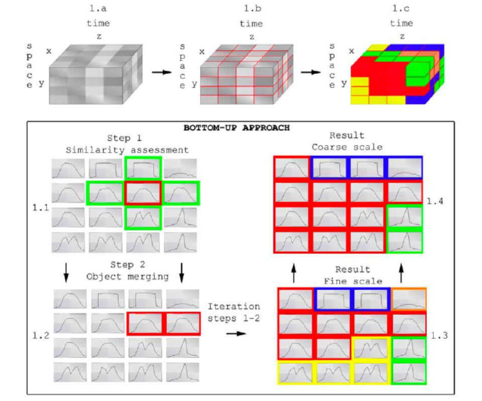
Various studies have explored the use of satellite time series to describe the seasonal dynamics of vegetation. Typically, the approaches do not take into account the spatial or hierarchical context of the data. Hence, the aim of ECOSEG project was to improve the integration of temporal information into hierarchical image segmentation by the development of a new enhanced multi-temporal hierarchical image segmentation (EMTHIS) methodology.
The proposed project encompassed three objectives: (1) improvement of MTHIS via the development of a new methodology (EMTHIS) to hierarchically cluster image time series data into similar spatio-temporal segments at a range of scales, (2) implementation, validation and optimization of EMTHIS on remote sensing datasets and (3) dissemination of EMTHIS tool to international scientific community. A novel conceptual methodology was in this context introduced to achieve the first objective. The second objective consisted in the implementation, validation and optimization of EMTHIS on remote sensing datasets by looking at spatial and temporal responses to stress agents in forests (such as insects and pathogens to drought and fire). Finally the developed methodologies and tools were disseminated to the international scientific community.
Project outcome
The development of the EMTHIS consisted of three steps: (i) the selection of improved measures for the similarity criterion S, (ii) the conversion of the conceptual methodology in an efficient algorithm, and (iii) the accuracy assessment of the algorithm. Step (i) consisted of comparing alternatives for existing difference criteria after an extensive literature review (submitted to Remote Sensing of Environment). The algorithm was developed in step (ii) and was presented and published in the IGARSS2008 proceeding. Finally, artificial datasets were used in step (iii) to determine the accuracy of a classification based on subsequence windows versus the existent methodologies that do not take subsequence windows into account. This process was described in the IGARSS2008 proceeding where the importance of using subsequence windows was illustrated.
Due to the software bug, the EMTHIS methodology could not be applied to actual remote sensing datasets. An alternate means or validating the EMTHIS analysis scenario for the proposed set of actual remote sensing scenes was therefore initiated. Moreover, the software is still being developed to assure that once EMTHIS is debugged CSIRO will test and optimize the algorithm within a forest health change detection framework.
| Project leader(s): | KULeuven - Geomatics and Forest Engineering | |||
| Belgian partner(s) |
|
|||
| International partner(s) |
|
|||
| Location: |
Region:
|
|||
| Related presentations: | ||||
| Related publications: | ||||
| Website: | http://www.kuleuven.be/onderzoek/onderzoeksdatabank/project/3E07/3E070252.htm | |||