Context and objectives
![]()
Understanding the response of soils to external drivers to assist decision making at all scales requires precise spatially referenced soil data and maps. The first generation of hyperspectral satellites was characterized by low signal to noise ratios (e.g. Hyperion 190-40:1 as the wavelength increases) and their application for predicting soil properties was limited. With the Hyperion project shut down since 2016, the launch of a future generation of hyperspectral and multispectral imagers is being finalized. These satellites have the spectral resolution and signal to noise ratio (500-180:1 depending on the wavelength) required to provide high resolution data on a number of topsoil properties. Once the satellites are operational one can foresee an increasing demand for a robust methodology to derive soil products covering the size of one or a couple of tiles (e.g. for EnMAP: 30 x 30 km) throughout Europe, using imagery acquired under optimal soil and weather conditions. The objective of the PROSOIL project is to develop methods to produce up-to-date soil property data through Multivariate Calibration (MVC) of the signal from the new generation of hyperspectral and multispectral satellites.
Project outcome
Results
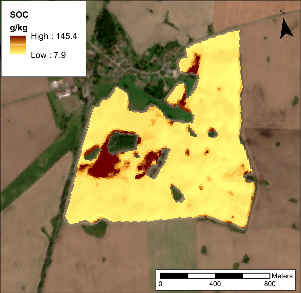
We developed a routine chemometrics approach to estimate SOC over large areas, using a continental scale and harmonized Soil Spectral Library (LUCAS database). This method is the first step of a new approach, named bottom-up, which allows SOC maps to be provided over a large area by airborne data without recourse to chemical analyses or any spectral transfer between laboratory and remote spectra, by exploiting the spectra and ancillary data of the European LUCAS topsoil database. This approach was tested on fields that were bare during the over flight in the three test areas. The results were compared to those provided by a direct calibration of the airborne spectra. The comparison between the independent validations of these two approaches did not show differences in terms of RMSE or RPD. The bottom-up approach was also tested using actual Sentinel-2 and simulated EnMAP data. The spatial resolution and the spectral quality of Sentinel-2 allow quantifying the in-field and regional variability of SOC content, while the low spatial resolution (30 m) of the new generation of hyperspectral satellite sensors may be a constraint for in-field characterization. The results obtained by the simulated EnMap showed a lower prediction accuracy than those obtained by airborne data (GSD: 4 m) in the same test site, and the EnMap data seem to be very sensitive to uncertainty of the SOC prediction process, especially to georeferencing error. The spatial resolution of the EnMap data could be a constraint to describe the SOC variation at small scale, however the EnMap data could be useful for regional soil characterization and for digital soil mapping. This step aimed to validate the derived soil products and evaluate the effects of degraded satellite signals on soil property prediction accuracy.
Products and services
The feasibility was demonstrated of a semi-automated, robust and harmonized calibration for soil organic carbon prediction from hyperspectral satellite systems in areas dominated by croplands. This calibration will become operational once the next generation of hyperspectral satellites is launched (EnMAP).The Sentinel-2 data proved to be promising for SOC monitoring over large area. In particular, the large amount of Sentinel-2 available data during the year can be exploited to detect croplands within the target image using multi-temporal series. In order to improve SOC prediction accuracy by remote sensing data, an automatic processing chain should be developed merging an operational version of the bottom-up approach with algorithms for detecting the best in-field conditions (bare cropland soils, soil moisture, etc.). Such a processing chain can be first tested on Sentinel-2 and subsequently be applied to the forthcoming satellites.
(Potential) users
Researchers, consultancy firms, and users or producers of soil information could use the proposed methodology to create soil property maps.
Outreach
Copernicus Sentinel-2 data to estimate soil organic carbon in croplands
| Project leader(s): | UCL - Georges Lemaître Centre for Earth and Climate Research | |||
| International partner(s) |
|
|||
| Location: |
Country:
Region:
|
|||
| Related presentations: | ||||
| Website: | https://www.elic.ucl.ac.be/modx/index.php?id=989 | |||