“Many low-lying coastal areas are going to disappear. In fifty years’ time the geography of the Pacific region will be quite different to the way it is today.” Prof Nunn
The western and central Pacific Ocean is dotted with 25,000 islands and islets; many of which are eroded volcanic islands, coral reefs or atolls with a maximum land elevation of 5m above mean sea level.
The 25 Pacific countries have contributed just 0.06% to global greenhouse gas emissions, but some of them could be simply wiped off the map by the rising seas brought about by global warming. Yet now, changing climate and sea levels are affecting their water supply, food production, fisheries and coastlines.
 « Mean sea level » at the coast is defined as the height of the sea with respect to a local land benchmark, averaged over a period of time, such as a month or a year, long enough that fluctuations caused by waves and tides are largely removed.
Changes in mean sea level as measured by coastal tide gauges are called “relative sea level changes”, because they can come about either by movement of the land on which the tide gauge is situated or by changes in the height of the adjacent sea surface (both considered with respect to the centre of the Earth as a fixed reference).
These two terms can have similar rates (several mm/yr) on time-scales greater than decades. To detect sea level changes arising from changes in the ocean, the movement of the land needs to be subtracted from the records of tide gauges and geological indicators of past sea level.
Widespread land movements are caused by the isostatic adjustment resulting from the slow viscous response of the mantle to the melting of large ice sheets and the addition of their mass to the oceans since the end of the most recent glacial period (“Ice Age”). Tectonic land movements, atoll decay, rapid displacements (earthquakes) and slow movements (associated with mantle convection and sediment transport) can also have an important effect on local relative sea level.
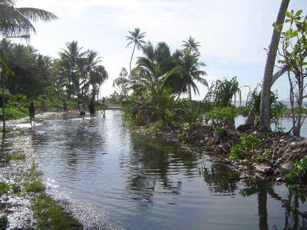
Just south of Funafuti Airport, sea water seepage flooding across Funafuti Road in February 2006 - Source
Why does sea level rise?
Sea level is affected by the combination of tidal, weather, climate and oceanographic conditions as well as geodynamic processes. So, in addition to long-term climate change, sea level is influenced by quasi periodic large natural climate fluctuations or by short term extreme events (tsunamis or tropical cyclones).
Global warming
Sea level change is an important consequence of climate change. The two major causes of global sea level rise are thermal expansion of the oceans (warm water occupies more volume than cold water) and the increased melting of land ice, glaciers and ice-shelves (only loss of land-based ice contribute to sea level rise). If the Greenland ice sheet was to melt, it would raise sea level by 7 m. Melting of the West Antarctic Ice Sheet would raise sea level by 5 m. But even just partial melting of these ice sheets will have a dramatic effect on sea level rise.
Climate variability
Variations in sea level and climate are inextricably linked, and both undergo interrelated seasonal, interannual and interdecadal fluctuations. Quasi-periodic fluctuations associated with natural phenomena such as El Niño or the Pacific Decadal Oscillation can be large and cause significant impacts. Particularly noisy or low frequency variations can conceal the underlying long-term trend over several decades.
Extreme events
Extreme sea levels arise when reinforcing combinations of tides, short-term weather effects, tsunamis or climate conditions occur. Abnormally high sea levels can cause flooding, coastal erosion and property damage. Abnormally low sea levels can be hazardous for navigation and reduce under-keel clearances for shipping operations in ports.
In recent years, El Niño events and extreme climatic events like severe storms have been more frequent, more intense and lead to more severe impacts.
How does sea level rise?
Satellite altimeters and tide gauges are complementary datasets used to determine sea level. Satellite altimetry provides measurements of absolute sea level against which tide gauge measurements of 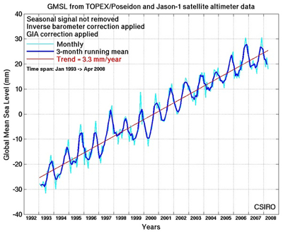 relative sea level can be compared.
Sea level data collected since 1992 by satellite altimeters, namely TOPEX/Poseidon and Jason-1, show that Global Mean Sea Level (GMSL) has risen at a rate of around 3.3 mm/year. This is more than 50% larger than the average value over the 20th century.
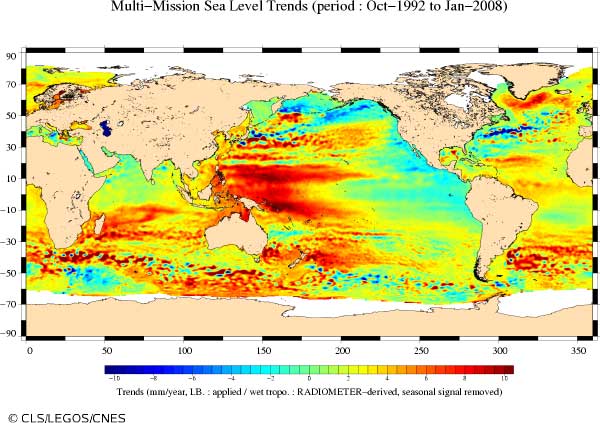
However global mean sea level change during this time has not been geographically uniform. Increasing sea levels in the western Pacific and falling sea levels in the eastern Pacific during this period are related to decadal fluctuations. Sea level trends in the southwest Pacific region are almost twice higher than the global average (around 6 mm/year). The largest rates in the southwest Pacific region are being observed along the South Pacific Convergence Zone and along the equator.
Source : CSIRO Marine and Atmospheric Research
In the future
The Intergovernmental Panel on Climate Change in 2007 predicted that global warming would cause mean sea level to rise by 18 cm to 59 cm by 2100 (depending on a range of greenhouse-gas emission scenarios), with a possible additional rise of 10 to 20 cm due to continued melting of polar ice sheets. A recent study suggests a new projection of up to 1.4 m in sea-level rise, caused by accelerating rates of loss from ice sheets in Greenland and Antarctica on account of higher global temperatures.
Aviso (Archiving, Validation and Interpretation of Satellite Oceanographic data), CLS, CNES
Impacts
The most serious impacts are caused not only by changes in mean sea level but by changes to extreme sea levels, especially storm surges and exceptionally high waves, which are forced by meteorological conditions.
Worldwide
The International Institute for Environment and Development (IIED) has analyzed the effect of a 10-meter rise in sea level. The study points out that 634 million people live along coasts at or below 10 m above sea level, in what is called the Low Elevation Coastal Zone. This massive vulnerable group includes one eighth of the world’s urban population. One of the countries most vulnerable is China, with 144 million potential climate refugees. India and Bangladesh are next, with 63 and 62 million respectively. Vietnam has 43 million vulnerable people, and Indonesia, 42 million. Others in the top 10 include Japan with 30 million, Egypt with 26 million, and the United States with 23 million.
A 50-cm rise in sea level would lead to the displacement of about 200 million people.
For low-lying islands
Low-lying islands, especially those lacking a surrounding shallow shelf, are particularly vulnerable to changes in sea level and storm patterns.
Any rise in sea level increases the frequency of flooding and this would be exacerbated by increased wave action. Saltwater intrusion is adversely affecting drinking water and food production and coastal erosion is arising. Higher temperatures also lead to more destructive storms; higher surface water temperatures in the tropics and subtropics mean more energy radiating into the atmosphere to drive storm systems. It is estimated that a sea level rise of « only » 20-40 cm could make an island such as Tuvalu (which has a mean elevation of 1.5 m above mean sea level and his highest point protruding at 5 m) uninhabitable. If rising sea-level predictions come true, it means that the entire 11,800-strong population would have to be evacuated within the next 50 years. The ocean could swallow the whole island, making Tuvalu the first country to be wiped off the map by global warming (already at least two small atolls in Kiribati have sunk beneath the Pacific).
Sources
Alofa Tuvalu
Altimeters chart sea level - Aviso (Archiving, Validation and Interpretation of Satellite Oceanographic data), CLS, CNES
Climate Change and Low-lying Pacific Islands by Philip Hall, Faerber Hall
Global Sea Levels, Past, Present and Future - UNESCO Intergovernmental Oceanographic Commission
Melting Ice and Rising Seas - Earth Policy Institute
Pacific Country Report, Sea Level & Climate - Commonwealth of Australia 2009, Bureau of Meteorology
Pacific Islands Ocean Observing System
Petites îles grands enjeux - Le courrier de l'UNESCO
Rising Sea Level Forcing Evacuation of Island Country - Earth Policy Institute
Sea level rise - CSIRO Marine and Atmospheric Research
Small Island developing states - UNEP
Vanishing Islands - UNEP
The Australian Baseline Sea Level Monitoring Project
The IPCC Explains... Sea Level Rise
The South Pacific Sea Level & Climate Monitoring Project
Links
Sea level rise of one meter within 100 years - EO Portal
Tuvalu - Global Education
This page was written in 2009, as additional information to the poster series "10 years of Imaging the Earth"