Published on 19 January 2024
A large mass of Arctic air spilled south from Canada and lingered for several days over much of the contiguous United States in mid-January 2024. The system brought a wintry mix of bitterly cold temperatures, freezing rain, and snow that extended from the Pacific Northwest all the way to the East Coast.
As the airmass came south, sub-zero air temperatures settled over Montana and the Dakotas on January 13 and 14. Air temperatures at a National Weather Service station in Billings, Montana, reached -30 degrees Fahrenheit (-34 degrees Celsius) on January 13, the lowest temperature recorded there since the site was established in 1999.
Wind chill—which describes how cold it feels to human skin due to wind—in Montana and the Dakotas reached as low as -60°F (-51°C). A wind chill of -20°F (-29°C) can cause frostbite in as few as 30 minutes. As of January 14, over 95 million citizens were under a wind chill advisory, according to the weather service. Dangerously cold temperatures remained over large swaths of the U.S. for several days.
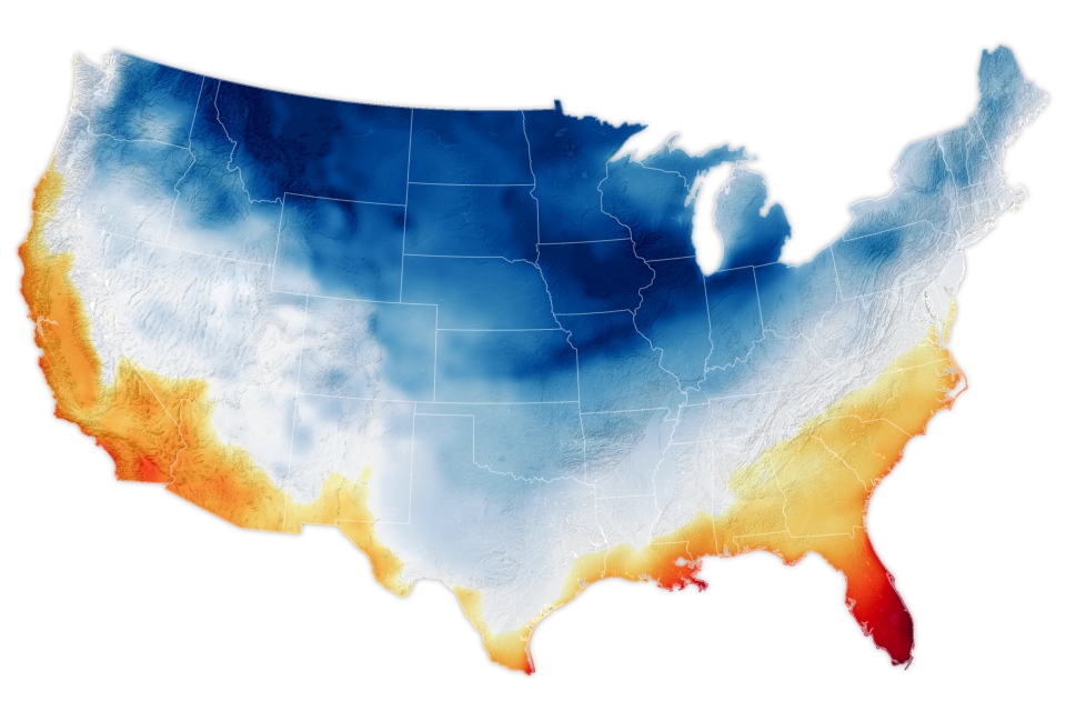
The map above shows air temperatures at 2 meters (around 6.5 feet) above the ground at 7 a.m. Eastern Standard Time (12:00 Universal Time) on January 15, as represented by the Goddard Earth Observing System Model. GEOS is a global atmospheric model that uses mathematical equations to represent physical processes. Measurements of temperature, moisture, wind speeds, and other conditions are compiled from NASA satellites and other sources, then added to the model to closely simulate observed reality.
The cold air extended as far south as Texas and Louisiana, where temperatures dropped into the teens on January 15 and 16. On January 16, the airport in Houston, Texas, registered 19°F—a new all-time low for that date.