Published on 17 October 2022
Explore Continental Habitat Mapping over Europe
The latest assessment on the state of the European environment, published by the European Environment Agency (EEA), shows that Europe’s biodiversity continues to decline at an alarming rate, with most protected species and habitats found not to have a good conservation status. It is clear that much more efforts are needed to reverse current trends and to ensure resilient and healthy nature.
To define more efforts or efforts that can have more effect we need to improve our biodiversity and ecosystem monitoring services in order to support our European policy makers. For this we are looking towards new Artificial Intelligence (AI) techniques. By using Neural Networks or Deep Learning methods and satellite-based high-resolution datasets such as the Copernicus High Resolution Vegetation Phenology Product (HR-VPP) we can improve our knowledge on where habitats occur across Europe, a crucial element for improving biodiversity conservation and taking specific actions.
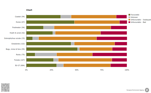
Conservation status of European habitats, source: European Environment Agency
AI to Model Terrestrial Habitat Distribution
The European Environment Agency (EEA) requested a feasibility study to use novel AI/ML techniques to model the distribution of high-resolution (10m) terrestrial habitats. This study, conducted in cooperation with Wageningen University, explored semi-automated solutions to generate continental habitat maps through the use of the high-resolution satellite based datasets together with other ancillary data and in-situ observations. The European Vegetation Archive (EVA), a continent-wide integrated electronic database of vegetation-plot records, acts as training data to open the option to characterize habitats at European scale in a harmonized way. Current habitat suitability maps are at coarse resolution and not recent, Article 17 dataset (Annex-I) represents the period 2013-2018 at 10 km spatial resolution, while representing the period until 2017 at 1 km spatial resolution. This novel approach generates recent (2020) habitat maps at 10m spatial resolution.