Published on 7 June 2022
The European Ground Motion Service (EGMS) was born as a response to a well-defined user request for a ground motion service on a continental scale. It is the result of a bottom-up process, starting back in 2016 when a task force was formed involving selected user groups and experts, which worked together to elaborate the European Ground Motion White Paper – the basis for the EGMS.
The EGMS is the latest offering of the Copernicus Land Monitoring Service (CLMS) that provides free and accessible ground motion data to any user. The service focuses on information regarding the motion of land, structures, and infrastructure in all Copernicus Participating States, plus the United Kingdom. Its aim is to give users reliable and timely information on ground motion for applications on a local, regional, or national scale, based on advanced interferometric analysis of Sentinel-1 synthetic aperture radar images.
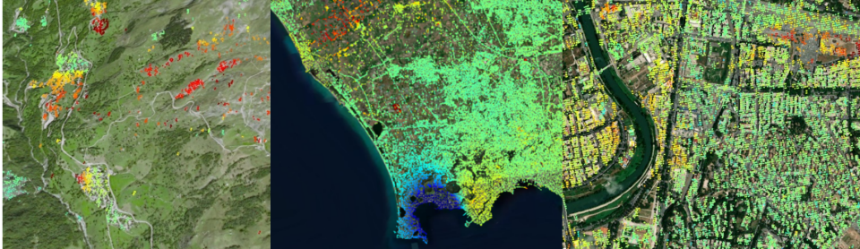
Left image: landslide and subsidence in mountainous area east of Lyon, France - Basic Product; central image: bradyseism in Campi Flegrei, Naples – Basic product; right image: metropolitan area of Rome- Basic product
credits: EEA/Copernicus Land Monitoring Service/EGMS
The EGMS provides data on a continental scale, in the form of maps colour-coded by the velocity of ground motion, in terms of millimetres per year. The first ‘baseline’ product, covering 2015 – 2020, is made from satellite data acquired every six days during that period. The EGMS ground maps are critical for studying, monitoring, and understanding a variety of deformation phenomena of both natural and anthropogenic origin such as landslides, subsidence, seismic and tectonic activity.
The products are obtained from multitemporal, harmonised, and quality controlled interferometric analysis of Sentinel-1 images, starting from February 2015, and will be validated against independent ground motion data. Interferometry can provide measurements of displacement since various ground features, as seen by the satellite, act as stable radar reflectors (Persistent Scatterers) against which calculations of their distance can be made. In an urban environment, there can be many hundreds, if not thousands, of ‘InSAR measurement points’ per square kilometre.