Published on 17 March 2023
ESA WorldCover supports sectors that are critical to our well-being, such as biodiversity monitoring, food security, carbon assessment and climate change by providing new levels of detail to our land maps, helping researchers, businesses and organisations to plan for a better future.

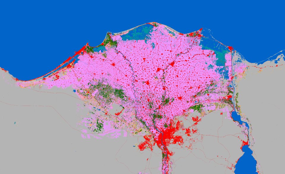
Land imaging of the Nile Delta in Egypt for food security using ESA WorldCover. The pink colour represents cropland, which dominates delta. The red colour represents built-up areas, which are increasing over time.
Until recently, most continental or regional land cover maps were based exclusively on high-resolution optical Earth observation data, from sources such as Copernicus Sentinel-2, Landsat or low-resolution imagery (>100m).
In response, ESA initiated the WorldCover project to create a global land map for 2020, which was completed in October 2021.
This project provided a freely accessible land cover product, which used data from both the Sentinel-1 and Sentinel-2 satellites of the European Union’s Copernicus Programme, to provide accurate, timely and high-resolution information on land use/cover for a variety of different sectors including: biodiversity monitoring, food security, urban planning, tourism, carbon assessment and climate change – at a resolution of 10m and a global overall accuracy of about 75%.

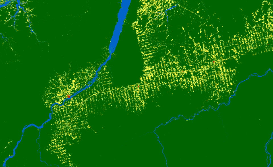
This map shows land imaging of the Amazon in Brazil for Carbon Assessment applications using ESA WorldCover. Deforestation can be tracked by monitoring tree cover (dark green colour), which gives way to grassland (yellow colour).
ESA WorldCover works by combining optical images from Copernicus Sentinel-2 with those from Copernicus Sentinel-1, which uses radar to penetrate cloud cover and functions throughout the day and night, imaging the entire Earth every five days.
This approach allows researchers to process the entire global surface in near-real time and provide unprecedented detail.
To ensure accuracy, independent validation is conducted by Wageningen University and other regional experts.
The WorldCover map is free to use and can be accessed and downloaded online on either your desktop or mobile device. The map shows 11 different land-cover classes, ranging from tree cover and shrubland to herbaceous wetland and mangroves, making it valuable for a plethora of different applications.
Following positive feedback from users, ESA chose to expand on the WorldCover project by creating a new version of even higher quality for the year 2021. This version was released on 28 October 2022, and improved the product’s global overall accuracy from 75% to 76.7%.

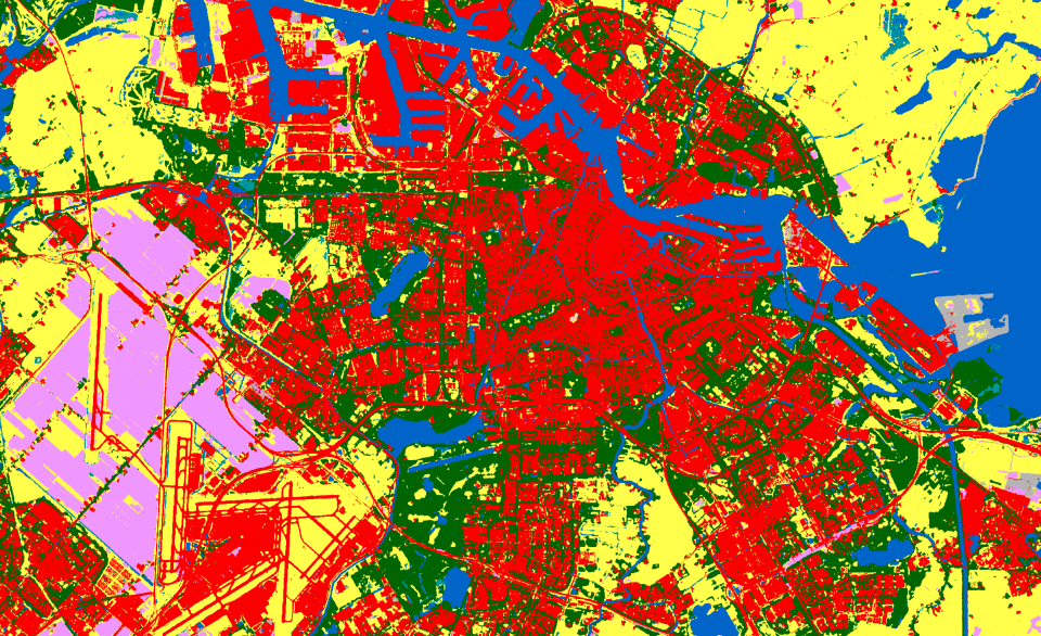
Land-use planning is facilitated with land imaging maps using ESA WorldCover, such as this one of Amsterdam in the Netherlands. Urban land cover shows a good distribution of tree cover (dark green colour) inside the city built-up area, which is not the case around the harbour area. Meanwhile a large part of the land around the airport is use for agriculture and therefore classified as cropland.
Response has been positive, with already over 5000 downloads of the WorldCover 2020 and WorldCover 2021 products from ESA’s EO4Society portal.
WorldCover is partnered with five major end users and a larger network of potential user organisations from a wide array of domains.
The five key users involved with WorldCover are the United Nations Convention to Combat Desertification (UNCCD), World Resource Institute (WRI), Centre for International Forestry Research (CIFOR), Food and Agriculture Organization (FAO), and the Organisation for Economic Co-Operation and Development (OECD). These users provided advice on 11 relevant classes and were invited to all project milestones.
About the Copernicus SentinelsThe Copernicus Sentinels are a fleet of dedicated EU-owned satellites, designed to deliver the wealth of data and imagery that are central to the European Union's Copernicus environmental programme. The European Commission leads and coordinates this programme, to improve the management of the environment, safeguarding lives every day. ESA is in charge of the space component, responsible for developing the family of Copernicus Sentinel satellites on behalf of the European Union and ensuring the flow of data for the Copernicus services, while the operations of the Copernicus Sentinels have been entrusted to ESA and EUMETSAT. |
Did you know that?Earth observation data from the Copernicus Sentinel satellites are fed into the Copernicus Services. First launched in 2012 with the Land Monitoring and Emergency Management services, these services provide free and open support, in six different thematic areas. The Copernicus Land Monitoring Service (CLMS) provides geographical information on land cover and its changes, land use, vegetation state, water cycle and Earth's surface energy variables to a broad range of users in Europe and across the World, in the field of environmental terrestrial applications. It supports applications in a variety of domains such as spatial and urban planning, forest management, water management, agriculture and food security, nature conservation and restoration, rural development, ecosystem accounting and mitigation/adaptation to climate change. |
Source:
European Space Agency (ESA). (2023b, March 16). Meet ESA WorldCover – Global Land Cover mapping at High Spatial Resolution. Sentinel Online – Sentinel Success Stories.