Published on 12 July 2024
Located in the heart of South America, Pantanal is the world’s largest wetland covering some 81,081 sq miles (210,000 sq km). The majority is in Brazil, split between the states of Mato Grosso and Mato Grosso do Sul. These open marshes are home to an immense variety of life – if you like to see animals in their natural environment, the Pantanal is an unmissable destination.
Recent wildfires in the region have caused unrepairable damage to the ecosystem.
This image captured by Copernicus Sentinel-2 on July 4th, 2024, shows the extent of fires as well as the contrast between burned and non-burned areas.
Short-wave infrared (SWIR) wavelengths are reflected by water in plants and soil, but also burned areas. Hot surfaces such as active fires create a powerful SWIR signal. Open water and sealed surfaces such as asphalt or concrete have weak reflectivity in SWIR. This composite uses B12 for the red channel, B8, near-infrared which is reflected strongly by healthy vegetation for the green channel, and the visible red band B4 in the blue channel of the composite. Therefore, water is black, bare soil is brown or grey, and vegetation is bright green. Burn scars are dark red, and active fires are bright red spots.
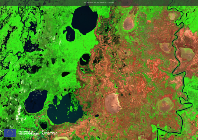
In this image, you can see the vigorous vegetation of the wetland around the network of river channels and lakes, including some dark green areas where vegetation is standing in water. Bare soil areas such as dry lake and riverbeds are reddish brown, while dark red areas are burn scars - for some of these, the active fire is also visible. Black areas are open water surfaces - or sometimes, cloud shadows!