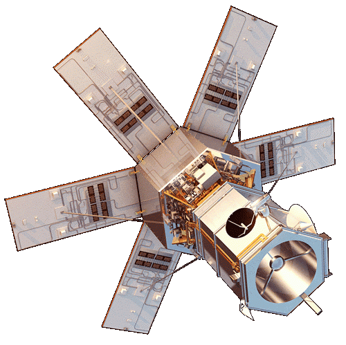
WorldView-4 was an imaging and environment-monitoring satellite from Maxar of the United States, which launched on 11 November 2016 to enhance European Space Imaging's customer offering with very high resolution imagery options.
Operating in coordination with WorldView-3 and the other satellites of the WorldView constellation, it offered high-resolution imagery at 31 cm resolution in panchromatic mode and 1.23 m in multispectral mode; it provided large area single pass (synoptic) collection, which eliminates temporal variations and offers geolocation accuracy and bi-directional scanning with daily revisits.
On 7 January 2019, WorldView-4 was retired when the satellite experienced a failure in its CMGs (Control Moment Gyros), preventing the satellite from collecting imagery due to the loss of an axis of stability.
Satellite characteristics
Launch Date - End 1478818800 - 1546815600
Status Decommissioned
Orbit type polar sun-synchronous
Altitude 617
Equatorial crossing time 10:30 (descending node)
Orbit period 96.96
Satellite family: Digital Globe - MDA Constellation
DigitalGlobe is an American supplier of very high-resolution commercial satellite imagery. DigitalGlobe owns and operates a fleet of Earth imaging satellites including IKONOS, Quickbird, GeoEye-1 and WorldView 1,2,3 and the recently launched WorldView 4 capable of seeing objects as small as 30 cm.On February 2017, DigitalGlobe has agreed to combine with MDA, the Canadian radar, telecommunications, and imagery corporation.
With IKONOS, a new era of 1m spatial resolution imagery began for spaceborne instruments in the field of civil Earth observation. IKONOS-2 was the world’s first commercial satellite to collect panchromatic images with 80 cm resolution and multispectral imagery with 3.2 meter resolution. It was decommissioned in March 2015 ending a 15 year mission life.
Sensor characteristics
| Sensor name | CAVIS (corrects for Clouds, Aerosols, Vapors, Ice, and Snow) |
|---|---|
| Sensor short description | |
| Sensor type | Imaging radiometer (Vis/IR) |
| Resolution class | Medium (30 - 300 m) |
| Spatial resolution | 30<br>30 |
| Swath width (at nadir) | 13 km |
| Revisit frequency | 4 days |
| Sensor name | WV110 (WorldView-110 camera) |
|---|---|
| Sensor short description | |
| Sensor type | Imaging radiometer (Vis/IR) |
| Resolution class | Submetric |
| Spatial resolution | 0.46<br>1.8 |
| Swath width (at nadir) | 16 km |