Context and objectives
The European Commission FP7 TIRAMISU project (Toolbox Implementation for Removal of Anti-personnel Mines, Submunitions and UXO) aims at providing the foundation for a global toolbox that will cover the main mine action activities, from the survey of large areas to the actual disposal of explosive hazards, including mine risk education and training tools. Twenty-four European teams led by the Royal Military Academy of Belgium joined their efforts in this 15M€ collaborative project (2012-2015). In particular, the toolbox will contain tools to facilitate land release.
(More info at: http://fp7-tiramisu.eu/)
The overall objective of SPRINT is to provide TIRAMISU with complementary information that should improve the quality of support of the risk analysis during the land release operations process by feeding the Integrated Geospatial System with EO-derived data related to the presence/absence of human activities. Data fusion will increase robustness of the results and facilitate dealing with large amounts of data.
Project outcome
SPRINT had been able to contribute in TIRAMISU work package WP 220: Tools for Non Technical Survey. In WP 220, several sub tasks have been defined and SPRINT can provide support to the following ones:
Sub-WP 221: Tools for collecting and acquiring data on Suspected Hazardous Areas.
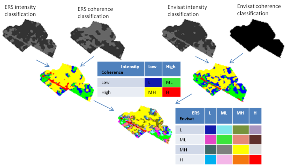
► SPRINT demonstrated that valuable information for the mines actions centers can be provided through the processing of radar image stacks acquired during and after a conflict.
Sub-WP 222: Tools for pre-processing remote sensing data
► SPRINT used successfully the COS Sarscape™ software and the objectives of WP 3 were achieved.
Sub-WP 223: remote sensing data and geographical information systems tools for supporting Suspected Hazardous Area reduction and assessment
► The outputs of the interferometric processing have been successfully manipulated in ArcGIS to generate subset images useful for the fusion analysis step. All outputs, whatever the level in the processing chain, are in a standard format compatible with any types of (open) Integrated Geospatial Systems.
| Project leader(s): | ERM - KMS - RMA - Signal and Image Centre | |
| Location: |
Region:
|
|
| Related presentations: | ||
| Related publications: | ||
| Website: | http://www.sic.rma.ac.be/research/RUIP/proj338.html | |