With global mean sea level rising because of climate change, Copernicus Sentinel-6 is the next radar altimetry reference mission to extend the legacy of sea-surface height measurements until at least 2030. The satellite carries a Poseidon-4 radar altimeter and a microwave radiometer. The mission is a collaborative effort between several organisations, aimed at providing accurate and timely information to improve the management of the environment, understand and mitigate the effects of climate change and ensure civil security. The European Space Agency (ESA), EUMETSAT, NASA, and the National Oceanic and Atmospheric Administration (NOAA) are jointly developing the Sentinel-6/Jason-CS mission, with funding support from the European Commission and support from France’s National Centre for Space Studies (CNES).
Sentinel-6 is the latest in a series of joint U.S./European satellite missions that measure sea surface topography beginning with TOPEX/Poseidon launched in 1992, followed by Jason-1 launched in 2001, Jason-2 launched in 2008 and finally Jason-3 launched in 2016. Together, these missions have ensured an unbroken time series of data critical to the study of circulation patterns in the ocean and about both global and regional changes in sea level and the climate implications of a warming world.
Sentinel-6A—renamed Sentinel-6 Michael Freilich in honor of the former director of NASA’s Earth Science Division—was launched on 21 November 2020 from Vandenberg Space Force Base, US by a SpaceX Falcon 9 rocket. Sentinel-6B is currently targeted to launch in November 2025. Discussions are currently ongoing about a third Sentinel-6 satellite to extend the time series well into the 2030s.
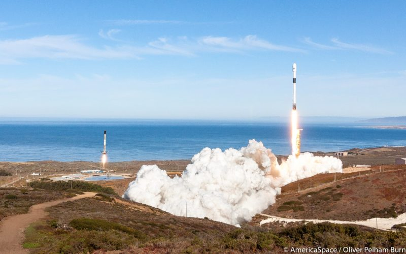
The Sentinel-6 Michael Freilich ocean observation satellite lifted off on a SpaceX Falcon 9 rocket from Space Launch Complex 4E at Vandenberg Air Force Base in California at 9:17 a.m. PST (12:17 p.m. EST) Saturday, Nov. 21, 2020. In this composite, the rocket can be seen at left landing. Photo: Oliver Pelham Burn / AmericaSpace
Sentinel-6 constellation
| Satellite | Sentinel-6 Michael Freilich | Sentinel-6B | ||
| Launch Date | 21 November 2020 | November 2025 | ||
| End Date | ||||
| Status | Operational | Planned | ||
| Orbit type | non-sun-synchronous "Jason orbit" | |||
| Altitude | 1,336 km | |||
| Orbit inclination | 66° | |||
| Orbit period | 112.43 minutes | |||
More on Copernicus
The Copernicus Programme is an Earth observation initiative that forms a crucial part of the European Union Space Programme. Managed by the European Commission in collaboration with various European organizations such as the European Space Agency (ESA), the European Organisation for the Exploitation of Meteorological Satellites (EUMETSAT) and the European Centre for Medium-Range Weather Forecasts (ECMWF), Copernicus aims to establish a comprehensive Earth observation capacity that is global, continuous, autonomous, and of high quality. The primary objective of the programme is to provide accurate, timely, and easily accessible information to improve environmental management, understand and mitigate the impacts of climate change, and ensure civil security.
Click here to visit our dedicated Copernicus page