Context and objectives
![]()
Ocean colour imagery from satellite sensors such as SeaWiFS, MODIS, MERIS and OLCI has been used for the monitoring of the open ocean and the coastal zone for the last few decades. These data sources are well established for the remote estimation of chlorophyll a concentration and water turbidity. With the availability of high resolution imagery from Pléiades (2 m) and Landsat and Sentinel-2 (10-60 m) people are starting to use remote sensing for the monitoring of the more abundant smaller inland water bodies, e.g. to satisfy Water Framework Directive requirements. Typical atmospheric correction algorithms are not suited for the processing of these images over small inland water bodies, and hence the development of a new algorithm is required. A new algorithm is developed specifically for Pléiades, and is validated using coincident in situ measurements.
Project outcome
Scientfic Results
- New atmospheric correction for metre and decametre sensors;
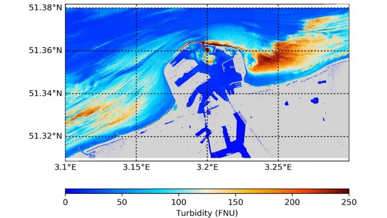
- Turbidity mapped at very high spatial resolution;
- Use of CubeSat imagery for water quality remote sensing;
- Development of a scheme to extract additional spectral information from overlapping bands;
- Validation and uncertainty assessment of field spectroscopy methods for algorithm and orbital data validation;
- A large dataset of in situ biological and optical properties of Belgian inland waters;
- Evaluation of spatial resolution requirements in the Gironde Estuary.
Societal (including environmental) relevance
- Study of water quality of (small) water bodies with high spatial resolution and frequent observations, potential for studying of inland water blooms;
- Water quality monitoring in a landscape perspective, with potential benefits for human activities,migratory birds and aquatic life.
Products and Services
- Binary and source code distribution of processing software for metre (Pléiades, SPOT, RapidEye and PlanetScope) and decametre (Landsat and Sentinel-2) scale satellite sensors;
- Water turbidity products for various global sites and the project study areas.
Potential users
Water quality managers, water quality research groups, satellite image providers, EU Water Framework Directive.
Outreach
PONDER: Monitoring coastal and inland waters with very high resolution imagery
PONDER : Surveiller les eaux côtières et intérieures grâce à l’imagerie très haute résolution
PONDER: Kust- en binnenwateren opvolgen met satellietbeelden van zeer hoge resolutie
| Project leader(s): | IRSNB/KBIN - Directorate Natural Environment - Ecosystems data processing and modelling | |||
| Belgian partner(s) |
|
|||
| International partner(s) |
|
|||
| Location: |
Country:
Region:
|
|||
| Related presentations: | ||||
| Website: | http://odnature.naturalsciences.be/ponder/ | |||