"We are greatly concerned that the full implications of mangrove loss for humankind are not fully appreciated” - Dr. N. C. Duke of the Centre for Marine Studies at the University of Queensland in Australia.
Growing populations and booming economies are threatening Asia’s coastal ecosystems. With half of the mangrove gone, inland areas are more vulnerable to storms and erosion.
Coastal development
About 60 % of the world’s population lives within 100 kilometres of the coastline on just 10% of the Earth’s land surface. Coastal areas are very accessible, making them centres of human activity, where people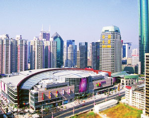 live, derive their recreation and their means of livelihood. People aggregate in a very narrow strip of land. It is also the preferred site for urbanization.
Asia stands out, as it contains about three quarters of the global population in the so-called low elevation coastal zones. Continuation of present urbanization patterns will draw still greater populations. In particular, China’s export-driven economic growth has been associated with intensive coastal migration.
Asia contains some of the richest and most extensive tropical coastal and marine ecosystems in the world. However, its growing coastal population and dynamic economic growth exert tremendous pressure on its coastal ecosystems. An estimated 70% is threatened. Especially mangrove forests are at risk.
The coastal boomtown of Shenzhen, China, one of the world’s fastest growing cities - Source
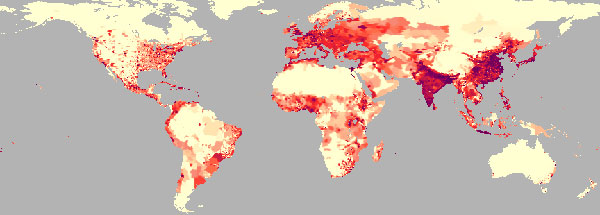
Population densities - Source: ReliefWeb
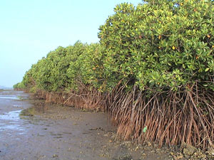
Mangrove forests
Mangrove forests are salt-tolerant, evergreen forests commonly found along sheltered coastlines in the tropics and sub-tropics.
They are characterized by low tree diversity, almost exclusively mangroves that are well adapted to their salty and swampy habitat by having breathing roots. These unique ecosystems provide refuge for wildlife; protection of coral reefs, sea grass beds and shipping lanes against siltation; and provision of habitat, spawning grounds and nutrients for a variety of fish and shellfish. It is estimated that 90% of all marine organisms spend some portion of their life cycle within mangrove systems. Of the world’s estimated 15 million ha, 40 % is found in Asia, half of it in Indonesia alone.
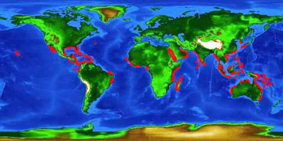
Mangrove distribution - Source
Economic benefits
Millions of fishermen, farmers and others depend on mangrove forests as a source of wood, medicinal plants, and food. As a nursery habitat for marine life, they are crucial to the health of offshore fisheries.
Mangroves help prevent and reduce coastal erosion, providing nearby communities with protection against the effects of wind, waves and water currents.
Disappearing fast
Because of its location, mangrove forests are disappearing at a rate of 1-2% per year, a pace that even surpasses the destruction of tropical rainforests. An estimated that 20 % of the planet's mangroves were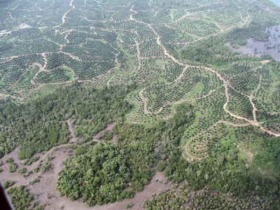 lost between 1980 and 2005: the greatest destruction had occurred in Asia, with 1.9 million hectares having been lost. In general, more than 50% of the mangroves areas have been destroyed in most countries of the Asia -Pacific region.
High population pressure in coastal areas has led to the conversion of many mangrove areas to other uses. Mangroves are most threatened by harvesting for timber and charcoal, real estate development, conversion for tourism and shrimp farms, and most importantly, clearing for agriculture (notably oil palm plantations and rice).
Mangrove from Southeast Asia and palm oil plantation - Photo courtesy of Emily Swaine.
The consequence of mangrove loss
These losses, combined with increasing fragmentation of mangroves, reduce their viability and the quality of the services-they provide.
The destruction of mangroves affects the fishery industries. When mangrove forests are destroyed, drops in local fish catches often result.
Similarly, loss of mangrove forests increased cyclone damage. As a consequence thousands of lives have been lost and serious damage has been inflicted to infrastructure. ASEAN secretary-general Surin Pitsuwan said Burma’s coastal areas were left exposed to 2008’s catastrophic Nargis cyclone as a result of destruction of the country’s mangrove forests.
Growing pressures of urban and industrial developments along coastlines, combined with climate change and sea-level rise is likely to expose residents more and more to seaward hazards.
Mangrove forest cleared for settlement and shrimp farms - Source

Mangrove lizard - Source
Source

Kingfish - Source
The 2004 Indian Ocean tsunami that killed nearly 230,000 people provided ample evidence that mangroves can protect or at the very least buffer communities from the worst impacts of tidal waves and storms. In the areas that saw the most intense tsunami activity, devastation was unavoidable, but in areas farther away, environmental factors other than proximity affected the damage done by the tsunami.
A released in the journal Science shows that areas buffered by coastal forests, like mangroves, were strikingly less damaged by the 2004 tsunami than areas without tree vegetation. The study's authors used before and after satellite photographs of the Cuddalore District in south-eastern India and surveys on the ground to reach their conclusions. The study confirms earlier laboratory experiments which have shown that 30 trees per 100 square meters may reduce the maximum flow of a tsunami by more than 90 percent
"Since the tsunami we have been working to help local communities to rebuild their lives and re-establish coastal vegetation in the areas affected by the tsunami in Aceh," said Nyoman Suryadiputra from Wetlands International–Indonesia and co-author of the study. "Local community members strongly support this action as they realize that areas with intact vegetation were less damaged." - Source: The Asian tsunami: a protective role for coastal vegetation. Science.
Sources
Mangrove atlas
Mangrove conservation
International Society for Mangrove Ecosystems(ISME)
The world’s mangroves – FAO forestry paper
Links
Envisat image of the Ganges Delta, harboring the world’s largest mangrove forest, the Sundarban
USGS International Program Mangrove Project
This page was written in 2009, as additional information to the poster series "10 years of Imaging the Earth"