Published on 20 August 2021
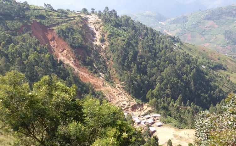 Landslides near a gold mine in Luhwinja in eastern DR Congo. The miners’ village is at the foot of the largest landslide. © Olivier Dewitte
Changes in the environment affect landslide risk
Landslides occur in mountainous regions all over the world, causing thousands of fatalities each year. The strong population growth in recent decades, the associated increase in food demand, and the development of economic activities have incited more and more people to settle in steeper and thus more landslide-prone areas, often at the expense of natural ecosystems. Deforestation destabilizes the soil as tree roots decay, further increasing landslide hazard.
It is widely recognized that population pressure and associated land use change, such as deforestation, affect landslide disaster risk. However, strong evidence to support this was still lacking. Investigating these human-nature interactions is challenging, especially in the Global South, where historical landslide and forest records are scarce.
Historical perspective on the Kivu Rift
In a new study, researchers from the KU Leuven, the Royal Museum for Central Africa (RMCA) and the Université Libre de Bruxelles (ULB) uncover these interactions between humans, the environment and landslides in the Kivu Rift in Africa close to the equator. This densely populated region in Burundi, Rwanda and eastern DR Congo is highly sensitive to landslides, which are usually triggered by heavy rainfalls.
"We explore the link between population, deforestation and landslides: we evaluate changes in forest cover and demographic trends, and their impact on landslide risk, during no less than six decades," explains geographer Arthur Depicker (KU Leuven, RMCA).
The researchers relied on more than 2000 historical aerial photographs from 1958, kept at the RMCA. This collection allowed them to study land use and deforestation (or afforestation) from the end of the 1950s until 2016 - a much longer time span than only satellite images would allow.
This research was conducted in the framework of the PAStECA project, a BRAIN-be project funded by BELSPO, and coordinated by the Royal Museum for Central Africa.