Published on 26 April 2023
As outlined in the European Space Agency’s Agenda 2025, the Agency is supporting Europe’s safety and security challenges by ensuring its space assets can aid natural disaster prediction.
Data disseminated by ESA’s Earth observation (EO) programmes are used to track droughts, floods, wildfires and other natural hazards, to help predict emergencies and protect people and infrastructure.
Knowledge of rainfall distribution is key to predicting drought or flooding events. While ESA’s EO missions have been helping to estimate rainfall for decades, recently scientists have used soil moisture data from ESA’s SMOS mission to provide near real-time estimates of precipitation in Africa.
The Soil Moisture and Ocean Salinity (SMOS) mission is a member of ESA’s family of research missions – the Earth Explorers. The satellite uses a microwave L-band sensor to measure soil moisture across the globe at a resolution of between 35 and 50 km.
Are natural disasters increasing due to climate change?
According to the IPCC, a changing climate can result in unprecedented extremes. Climate change is impacting the water cycle, bringing more intense rainfall, flooding and drought. Extreme events associated with sea level rise could happen every year by the end of the century. The aftermath of one natural disaster may precondition successor events: drought creates conditions for wildfires, followed by heavy rain leading to landslides.
Soil moisture data advance rainfall products
Since many regions of the continent rely heavily on agriculture, unpredictable droughts can have severe impacts on African economies. It was found that the use of SMOS data systematically enhanced the high-resolution rainfall product, which could benefit citizens by improving water management and facilitating operational applications to predict drought.
Long-term L-band datasets from SMOS have also been used by a team of researchers in Spain, to develop a new drought monitor. The monitor is based on soil moisture anomaly, namely the difference in soil moisture and the average over the 12 + year lifetime of the SMOS mission. It has been used to predict extreme drought in the Sahel region of Africa and the Ebro basin, a wheat growing region in Catalonia, northern Spain.
Synergy of radar data helps predict flooding
Floods can be one of the most devastating natural disasters. Because of our climate crisis and sea level rise, floods are now more prevalent and pose a serious threat.
Space-borne radar instruments are a powerful tool when it comes to flood monitoring, because they can penetrate clouds that often gather over floodwaters, providing an accurate picture of the crises as it unfolds.
Researchers in Denmark have explored the value of using a synergy of radar data for hydrological monitoring and modelling. In five African river basins, a combination of data from ESA’s Heritage Mission Envisat, Jason-2, Copernicus Sentinel-3 and CryoSat were successfully used to predict flooding.
Long-time series from ESA’s ERS mission – disseminated via the Agency’s Heritage Space programme – have contributed to flood hazard and risk assessment in Peru, by examining the evolution of the geomorphological landscapes and identifying processes that can cause disasters.
Accurate, live mapping of natural disasters can aid emergency management of an evolving situation. During the recent flooding of the Kabul River in Pakistan, PlanetScope – whose data are accessible via ESA’s Third Party Mission (TPM) programme – provided invaluable, very high resolution imagery of the flooded river basin.
Sequence of images showing lingering flood water
click here to view the animation at full resolution
ESA also contributes to the International Charter Space and Major Disasters, which combines EO assets from different space agencies to coordinate rapid response to major disasters.
Rapid mapping aids crisis management
A Python open-source library improves rapid mapping services by enabling easy opening of imagery from multiple satellite sensors, both optical and SAR, from over 20 TPM and Copernicus Sentinel missions. This near real-time delivery of geo-information can help emergency services respond quickly to natural disasters.
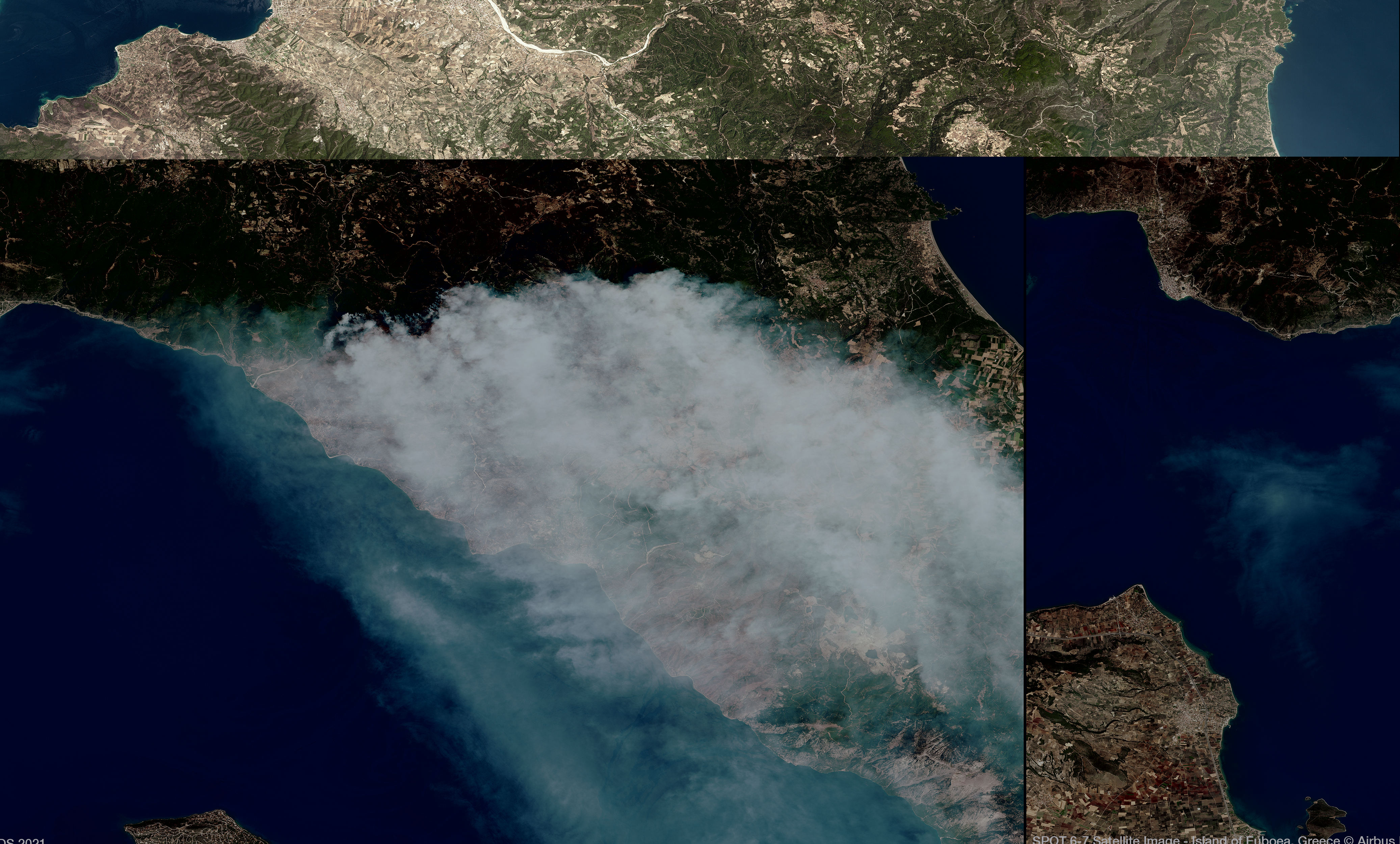
As record high temperatures continue across western Europe, persistent and deadly wildfires cause extended havoc. Another TPM, GEOSAT-1, delivers medium-resolution images and a very wide swath, enabling the high-frequency capture of imagery from huge areas of Earth’s surface. In this way GEOSAT-1 can monitor rapid environmental changes and help accelerate crisis management efforts.
In the summer of 2021, as a string of wildfires advanced across parts of Portugal, Spain and Italy, GEOSAT generated high-resolution maps to detail the spread of the fires.
In the Castro Marim region of Portugal, the satellite delivered near real-time imagery to crisis management teams - within 40 minutes of collection - enabling rapid intervention to protect life and infrastructure.
Atmosphere-monitoring missions also contribute to investigating the impact of wildfires. The Odin satellite houses the Optical Spectrograph and Infrared Imaging System (OSIRIS), which detects aerosol layers and retrieves altitude profiles of terrestrial atmospheric chemical species. Researchers recently used Odin’s OSIRIS sensor to investigate whether plumes of smoke released by large wildfires deplete the ozone layer.
Part of ESA’s Earth Explorers programme, Aeolus is the first spacecraft capable of using lasers to measure global wind profiles. Its data have proven useful in improving forecast studies of tropical cyclones - such as Hurricane Ida in 2021.
Aeolus data have been used to improve a long-established hurricane forecasting system developed in the US, as well as helping track the volcanic explosion of the Hunga Tonga-Hunga Ha’apai volcano in 2022.
How are satellite data used to track natural disasters?
Remote sensing satellites orbit above Earth’s atmosphere and can produce up-to-date information on vast geographical locations. Certain satellites orbit Earth frequently, measuring environmental changes in near real-time. Their data combined with cutting-edge analysis techniques, such as artificial intelligence and machine learning, provide important insights on natural disasters.
Swarm data support tsunami detection
Research has shown the existence and detectability of tsunami-triggered gravity waves in the ionosphere. As part of ESA’s funded COSTO project (COntribution of Swarm data to the prompt detection of Tsunamis and Other natural hazards), data from ESA’s Swarm mission have been shown to improve ionospheric-based tsunami detection and characterisation, especially after major earthquakes.
Tragic and economically challenging events induced by flooding, drought, wildfires or tsunamis, can be avoided with accurate mapping and well-functioning early warning systems.
As the climate crisis escalates, many natural hazards are increasing in frequency and EO data prove fundamental to monitoring these events and mitigating their damage.
How can AI help to prevent natural disasters?
Artificial intelligence (AI) has gained traction in natural disaster management due to advances in algorithms and increases in computational power. AI can harness vast amounts of high-quality remote sensing data to predict extreme events and provide near real-time information on natural disasters.
Source:
European Space Agency (ESA). (2023f, April 25). Remote sensing data map impacts of natural hazards. Earth Online.