Published on 3 May 2011
The fire that ravaged the Hautes Fagnes on 25 and 26 April is the largest the region has ever seen. More than 1,300 hectares of vegetation were destroyed, representing nearly a third of the 4,500 hectares designated as a nature reserve. For those who find it difficult to visualize these figures, this is equivalent to around 2,000 football pitches.
A few days earlier, the red flag indicating that access to the reserve was prohibited had been raised. Indeed, as winter drew to a close, the vegetation, which had not yet had a chance to regrow, was subjected to severe drought, creating conditions conducive to the outbreak of fires. The very strong winds contributed to the rapid spread of the flames, but also kept the fire confined to the surface, protecting the peat.
Fortunately, the fire caused no casualties, and the impact on flora and fauna is expected to be relatively limited. If conditions are favorable – that is, if it rains – the vegetation could recover within a few weeks.
The crisis unit of the Federal Public Service (FPS) Interior has activated the European GMES SAFER service. This emergency response service enables rapid mapping based on data acquired by Earth observation satellites.
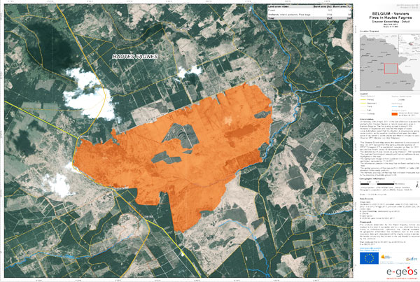
Map showing the extent of burnt areas, produced on 2 May 2011 for the European GMES SAFER service.
This map showing the extent of the burnt areas was produced by semi-automatic analysis of a SPOT 5 image (spatial resolution 2.5 m) of Bois Roslin acquired on 1 May 2011. The boundaries of the affected area were superimposed onto a QuickBird image with a spatial resolution of 0.6 m.
More info: