Context and objectives
![]()
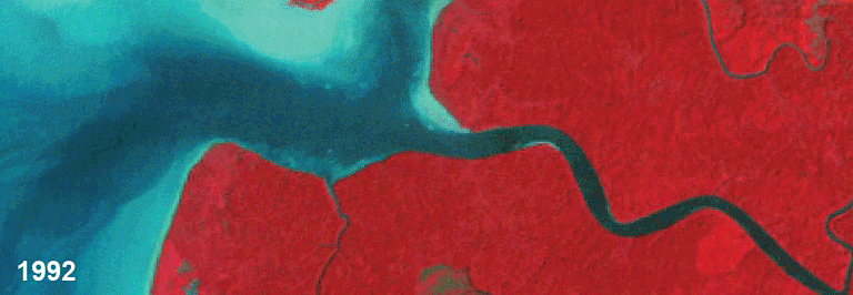
For mangrove forests, the development of robust remote sensing methods for mapping and monitoring their biophysical properties is becoming increasingly important as anthropogenic processes (e.g., pollution) and events (e.g., clearance) lead to significant losses across their range. For maximum benefit however, focus needs to be on the integration of temporal data from both optical and radar sensors as each provides unique but complementary information on mangroves. The main goal of this project therefore is to establish how the use of radar and optical remote sensing data can be optimised for quantifying the changing extent, structure, species composition and above ground biomass (AGB) of mangroves, with specific focus on the expansive mangroves within the Matang Mangrove Forest Reserve (MMFR) in Malaysia. This area has been silviculturally managed since 1902 and the areal extent of mangroves has changed very little. Most of the silviculture takes place in the productive forest, whereas several types of protected forest constitute the protective forest. Time series of optical and radar remote sensing data will be used to evaluate the viability and sustainability of logging. Comparisons will be made between productive and protective forests.
Project outcome
Scientific results
- Lucas et al. (2019). Remote Sensing of Environment. Accepted.
- Lucas, et al. (2019). Land Degradation & Development. Revised version submitted.
- Otero, et al. (2019). Forests. Submitted.
- Otero, et al. (2019). Remote Sensing 11 (7), 774. https://doi.org/10.3390/rs11070774
- Otero, et al. (2018). Forest Ecology and Management 411, 35 – 45. https://doi.org/10.1016/j.foreco.2017.12.049
Products and services
- UAV protocol for monitoring mangrove areas under silvicultural management
- Clear-felling map
- Recovery time map
- Annual forest age class maps (1987 to 2016)
- Canopy cover and dead material maps (1987 to 2016)
- Height and aboveground biomass maps
- Monitoring system - Earthtrack https://earthtrack.aber.ac.uk/globalMangroveWatch/
Potential users
- Forestry Department of Perak
- Charcoal contractors in MMFR
- Mangrove conservation community
- Remote sensing community
- Nnature restoration and rehabilitation community
Outreach
MAMAFOREST: Managing mangrove forests from the sky

| Project leader(s): | ULB - Systems Ecology and Resource Management Research Unit | |||||
| Belgian partner(s) |
|
|||||
| International partner(s) |
|
|||||
| Location: |
Continent:
Country:
Region:
|
|||||
| Related presentations: | ||||||
| Website: | https://sites.google.com/site/mamaforestproject | |||||