Publié le 30 mai 2023
Volcanic ash released at aircraft cruising altitudes poses a substantial risk to aviation. It can lead to temporary engine failure and permanent damage, unreliable readings of vital navigational instruments and reduced visibility.
Additionally, it can cause long-term economic consequences by shortening the engine's lifespan or damaging its components.
Consequently, during volcanic eruptions, airspace contaminated with ash imposes restrictions that disrupt air traffic, resulting in significant financial losses.

The PANGEA observatory is located on the island of Antikythera
One of the most extreme incidents was the Eyjafjallajökull eruption in 2010 which grounded more than 100,000 flights, and this week flights were suspended at Sicily's Catania airport due to ashfall from Mount Etna.
Early warning systems can help reduce the impact on aviation by providing forecasts of how volcanic ash will spread. The performance of these forecasts depends on the accuracy of the wind information used in the models.
Currently, wind profile measurements are obtained from radiosondes, commercial aircraft ascents and descents and ground-based wind lidars and radars. The distribution of these measurements is, however, sparse, and lacks global coverage.
Launched in August 2018, ESA's Aeolus satellite uses a sensor called the Atmospheric Laser Doppler Instrument (ALADIN) to acquire wind profiles on global scale.
ALADIN can measure the speed of winds sweeping across clear skies – known as Rayleigh winds – as well as within light aerosol layers and clouds, known as Mie winds.
The mission fills vast observation gaps in wind observations, particularly over the oceans, poles, tropics, and the Southern Hemisphere, providing consistent wind profiling observations worldwide.
The new paper – led by scientists at the National Observatory of Athens – focused on the dispersion of volcanic ash from an eruption at Mount Etna, which is one of the most active volcanoes on Earth.
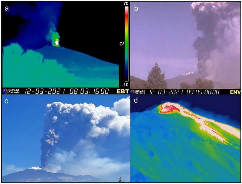
Activity of Month Etna on 12 March 2021
In early 2021, the volcano produced a series of paroxysmal episodes resulting in tephra and sulphate emissions with the volcanic plume drifting eastwards over the eastern Mediterranean region.
The team examined the impact of Aeolus wind profiles on an existing regional meteorological model, by comparing its performance with and without assimilation of the mission's observations.
The impact of the assimilation of Aeolus data was assessed using surface-based lidar measurements of the plume from the PANGEA observatory of the National Observatory of Athens.
It was found that the predictions of the volcanic ash plume position shifted considerably when Aeolus data were incorporated, showing that the volcanic cloud travelled much faster towards the island of Antikythera in Greece. According to the PANGEA observations, forecasts that drew on Aeolus data displayed a considerable improvement on the simulated shape and position of the ash cloud.
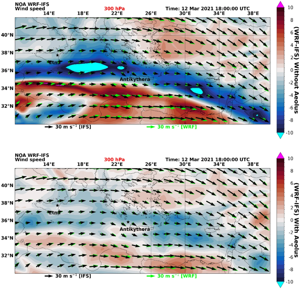
Impact of Aeolus on windspeed measurements
This result clearly demonstrates the potential of Aeolus for improving volcanic ash forecasting and hence aviation safety, highlighting the necessity of future wind profiling satellite missions such as Aeolus 2.
Source:
European Space Agency. (2023). Aeolus enhances volcanic ash forecasts for aviation safety. Earth Online.