Publié le 17 juillet 2024
As heat waves become more intense due to climate change, people in cities all over the world are facing more challenging summer conditions. Among them is Lahore, a city in northern Pakistan where only about ten percent of the population has access to air conditioning, and decades of rapid urbanization have strengthened the urban heat island effect. However, integrating green spaces into the city can help offset warming, as satellite data make clear.
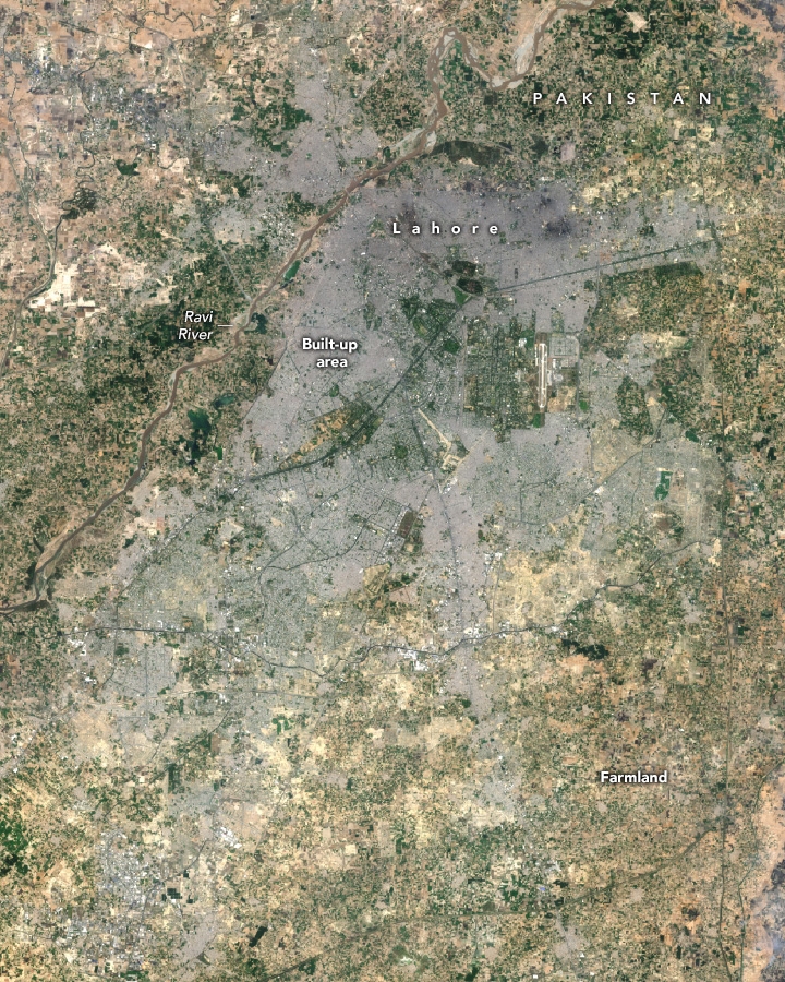
Situated in northeastern Pakistan along the Ravi River, Lahore is one of the fastest-growing cities in the world. Home to 3 million people in 1984, its population has soared to more than 14 million in 2024, according to United Nations data. The size of the city’s footprint on the landscape has ballooned as well, with observations from Landsat satellites indicating that built-up areas have replaced more than 200 square kilometers (77 square miles) of farmland and other green space around the city since the 1980s.
Greening projects in Lahore could help cool the city as climate change and rapid urbanization intensifies the urban heat island effect.
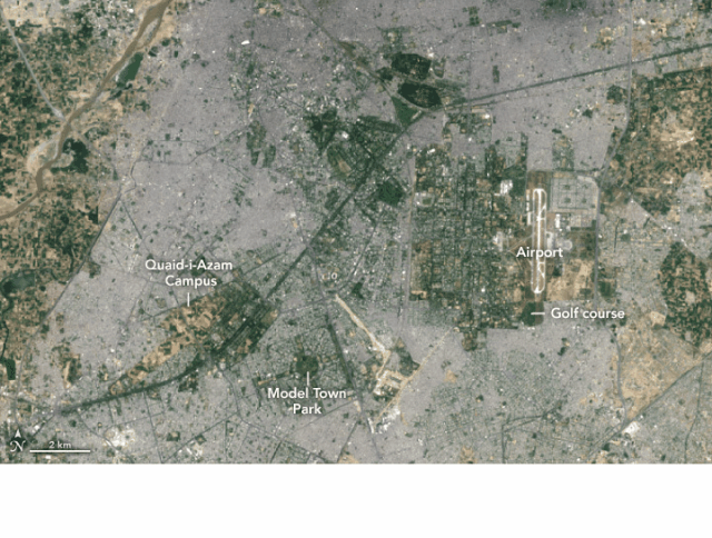
The OLI (Operational Land Imager) on Landsat 8 captured the image above (left) on May 16, 2024. Built-up areas appear gray; farmland and other open space appear green. The city includes several parks, urban forests, golf courses, athletic fields, botanical gardens, and graveyards with green vegetation.
The other image (right) shows nighttime land surface temperatures (LSTs) observed by NASA’s ECOSTRESS (Ecosystem Spaceborne Thermal Radiometer Experiment on Space Station) on May 8, 2024, at 9:13 p.m. It shows the region during a severe and persistent early summer heat wave that, at times, elevated daytime air temperatures above 45 degrees Celsius (113 degrees Fahrenheit), with heat indices that, incorporating humidity, made it feel more like 49°C (120°F). ECOSTRESS uses a scanning radiometer to measure thermal infrared energy emitted from Earth’s surface. Note that the sensor measures land surface temperatures, not air temperatures.
In the broader ECOSTRESS map below, green spaces such as wooded areas, grassy areas, parks, and farm fields were significantly cooler (blue and yellow) than densely developed areas. Vegetation and bodies of water do not absorb and re-emit heat as easily as common building materials such as concrete, asphalt, and steel. This can lead to differences of several degrees between developed urban areas and rural outlying areas—the urban heat island effect.
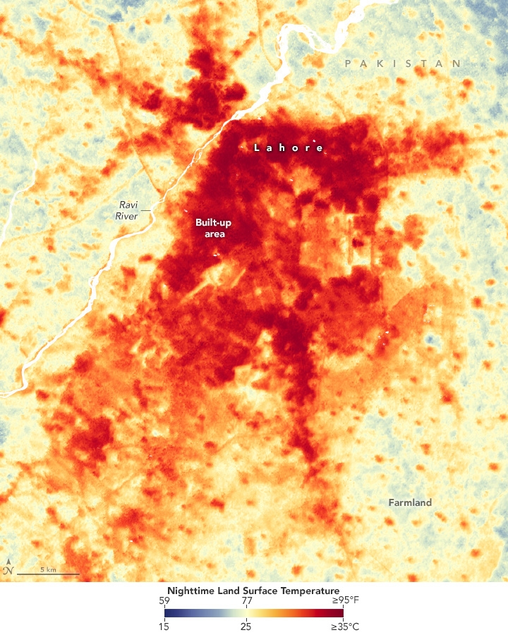
Differences in surface temperatures between developed and natural areas, known as surface urban heat islands, tend to be more pronounced than temperature differences associated with atmospheric heat islands, particularly during the daytime. “Surface urban heat islands exacerbate air temperatures by trapping heat and releasing it slowly, especially at night,” explained Muhammad Nasar-u-Minallah, a geographer at the University of the Punjab in Lahore. “The lack of green spaces and vegetation in urban settings further limits natural cooling mechanisms, such as shade and evapotranspiration, intensifying the heat.”
Heat islands can lead to considerable variation in land surface temperatures within cities. In Lahore, the green spaces in Quaid-i-Azam Campus and Model Town Park were 3.7°C and 2.0°C (6.6°F and 3.6°F) cooler, respectively, compared to nearby urban areas on the night of May 8, 2024, said Ashley Agatep, a Chapman University student intern working with the ECOSTRESS team at NASA’s Jet Propulsion Laboratory. Some of the coolest areas were golf courses and farmland east of the airport, likely because irrigation for grass and crops keeps the land surface cool. These differences in the ECOSTRESS data are visible in the detailed view of the city’s core at the top of the page.
“The fact that ECOSTRESS can make detailed measurements of land surface temperatures of such small areas is a testament to the sensor and the value of the data,” said Glynn Hulley, a remote sensing scientist at NASA’s Jet Propulsion Laboratory and a member of the ECOSTRESS team. Researchers working with these data have developed a processing technique that “sharpens” its thermal information by merging it with more detailed observations from Landsat and Sentinel satellites. The technique enhances the resolution of the data, improving it from 70 meters per pixel to about 20 meters per pixel.
Exposure to heat can cause heat exhaustion and heatstroke, particularly for older people, young children, and people who work outdoors. According to the World Health Organization, heat is the world’s leading cause of weather-related deaths and can exacerbate underlying illnesses, including cardiovascular disease, diabetes, and asthma. The health organization attributes 489,000 deaths to heat each year, with 45 percent of them occurring in Asia.
According to one global climate risk index, Pakistan is the world’s fifth-most vulnerable country to climate change, in part because of heat-related risks. One recent analysis of climate data conducted by The Washington Post and CarbonPlan concluded that more than 190 million people in Pakistan will be exposed to dangerous levels of extreme heat for at least a month each summer by 2030, the second most of any country in the world.
To help combat the heat, officials announced in 2021 that they were establishing Asia’s largest Miyawaki forest in China Park in northwestern Lahore as part of a broader effort to establish more than a dozen of these multi-layer, fast-growing forests in the city. Pakistan has also launched a nation-wide effort to plant 10 billion trees. Land surface temperature data from ECOSTRESS, Landsat, and other satellites could be used to assess whether such greening initiatives are blunting the intensity of the city’s heat island, according to Hulley. They can also be used to help assess which neighborhoods in Lahore are most vulnerable to heat-related illnesses, he added.
But planting trees may not be sufficient to counteract the warming from development, said Sawaid Abbas, a remote sensing scientist at the University of the Punjab. A recently published analysis of Landsat observations of Lahore indicates the scale of the challenge: an 18 percent increase in built-up area has contributed to an increase in land surface temperatures of 3.7°C (6.6°F) between 2000 and 2020.
“The city is now rapidly expanding in its northern regions, and these developments are on track to transform another 200 square kilometers of green space into built-up areas in a few decades,” Abbas said. “Lahore will likely need to pursue a combination of strategies, such as the installation of green roofing, green walling, and other nature-based solutions.”
NASA Earth Observatory images by Wanmei Liang, using Landsat data from the U.S. Geological Survey and ECOSTRESS data from the ECOSTRESS Team. Story by Adam Voiland.
Source:
NASA Earth Observatory. (2024, July 17). Beating the heat in Pakistan.