Publié le 19 juillet 2023
A climate scan to discover specific climate measures
Precision agriculture, also known as smart farming, involves the use of advanced technologies and data-driven approaches to optimize crop production. For several years, more and more farmers use precision farming techniques such as GPS-guided machinery, remote sensing and data analysis to support and improve their management practices. These technologies allow farmers to integrate climate-robust operations such as applying agri-chemical inputs precisely in order to reduce their environmental impact.

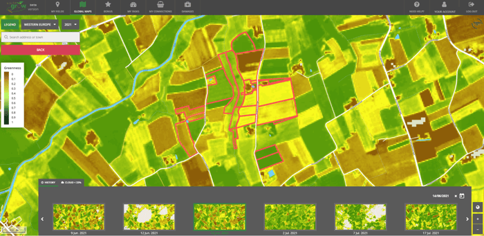
Sentinel-2 derived field zoning during multiple years to support decision making, © WatchITgrow
Klimrek is a VLAIO project that started in September 2019 to support dairy farmers, pig farmers and arable farmers in switching to more climate-friendly and climate-robust business operations. Together with the Agricultural Research Centre (ILVO) and the farmer’s association ‘Boerenbond’ we developed a ‘climate scan’, a company -specific screening tool to analyse a farm’s climate robustness and discover the most appropriate climate measures. Within VITO Remote Sensing we checked how we could support the screening tool for arable farmers with potatoes in rotation with EO data and remote sensing services. By using EO-based services like WatchITgrow for example, farmers can improve crop monitoring efforts and optimize fertilizer use and irrigation, leading to nutrient and water savings.
The value of EO data
Much has been done in recent years to assess the climate impact of agriculture, determine climate adaptation measures and how we can support our farmers in this, but little use has been made of satellite imagery and remote sensing. Within Klimrek we demonstrated the effectiveness of EO-based services and technology. We started with 15 pilot farms, 5 farms per sector, who helped us set up a detailed and user-friendly scan that determines how climate-friendly a farm’s operations are and what measures the farmer can take to make the business operations even more climate-friendly but also climate-robust, without compromising convenience and economic feasibility.
WatchITgrow, the online crop monitoring platform, already provides intelligible data such as the satellite (Sentinel-2) derived greenness, the Fraction of Absorbed Photosynthetically Active Radiation (fAPAR, see figure below) or the Normalized Difference Vegetation Index (NDVI, see figure below), all excellent indicators for monitoring crop performance at the field scale. This data allows farmers to take specific actions, only where and when it is needed. By doing so, they can reduce the use of crop protection and fertilizers and still maintain their crop yields on the one hand and reduce their climate footprint on the other hand.

Sentinel-2 derived greenness (fAPAR) to monitor crop performance across fields over time, © WatchITgrow
Cover crops, crop rotation and crop diversity
A ‘climate scan’ is company-specific, meaning that the proposed climate measures will differ for every farm. A set of frequently occurring climate measures are:
- Cover crops
Cover crops are non-commercial crops planted in the off-season to cover the soil surface. The use of cover crops, such as legumes or grasses, reduces nutrient leaching and soil erosion, increases soil organic matter and promotes biodiversity.
- Crop rotation
The practice of alternating crops in a field, contributes to soil health and reduces the risk of pest and disease outbreaks.
- Crop diversification
Crop diversification enables farmers to adapt to changing climate conditions. Different crops have different tolerances to temperature, rainfall, drought, waterlogging, … By growing a variety of crops instead of relying on a single crop, farmers can handle the risks associated with climate change and also improve soil quality.
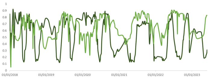
The CropSAR fAPAR time series shows the diversity of crop performance in different field conditions over multiple growing seasons.

Time series CropSAR demonstrating crop performance during multiple growing seasons
Water management
When looking towards climate-resilient measures, we also look at water management. Water scarcity and extreme weather events such as floods and droughts pose major challenges to agriculture. Farmers are more and more challenged to optimize their water management strategies to ensure efficient water use and reduce the impact of climate variability.
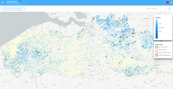
WaterRadar, which is integrated in WatchITgrow, is an important online tool for matching water supply and demand. Techniques such as precision irrigation, climate adaptive drainage and the construction of water retention ponds help optimize water resources and improve drought resilience. WaterRadar is used for planning water-related climate measures. These measures will improve crop performance, which can be monitored using vegetation indicators (see figure below).

Crop water demand during the growing season, © WaterRadar
Support farmers in times of extreme weather conditions
Klimrek is in line with VITO’s ambition to develop remote sensing enabled solutions to support farmers in managing and improving their operational processes in times of increasingly extreme weather conditions. We were surprised to see how company-specific some climate measures are. What works for one farmer may therefore not work for another, even if their business practices are very similar. This is induced by the great diversity of soils, landscapes and agricultural activities in Flanders. All the more reason to opt for an approach tailored to individual companies.
Applying remote sensing and data science, in combination with improved practices in the field, can reduce crisis-management and lead to a climate-resilient agriculture in Flanders which is more urgent than ever.
Farmers who are interested to explore how to their business can become more climate-friendly as well as climate-robust can request a ‘climate scan’ (Dutch website).
Source:
Climate-resilient agriculture in Flanders. (2023, July 17). Prism | VITO Remote Sensing.