Publié le 7 octobre 2022
Linked to climate change impacts, Pakistan has been undergoing severe flooding all summer, leaving thousands displaced, and causing severe devastation to agriculture with possible health issues in various areas—the Copernicus Sentinels are bringing valuable information on assessing the damage, for aid purposes.
The summer monsoon weather system is a major component of the water cycle in our sub-continent. It replenishes underground water channels, filling major water reservoirs for irrigation of the main wheat crop across Pakistan, India and Bangladesh, and boosting green index across vast rangelands.
The 2022 torrential rains across southern Pakistan, mainly in the Sindh and Balochistan provinces, triggered one of the most severe floods in Pakistan’s recent history. Hundreds of thousands of homes have been destroyed, while many public health facilities, water systems and schools have been wrecked or damaged.
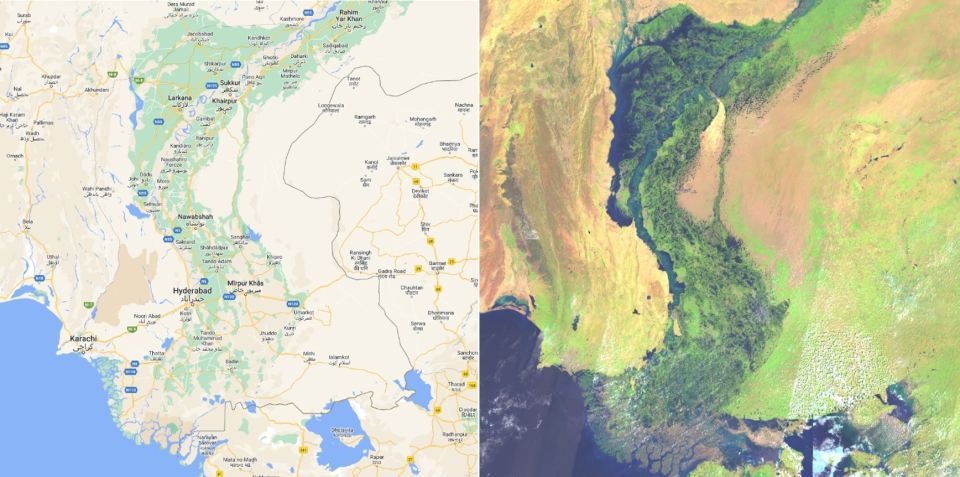
Flood water extent view of Sindh province
Entire villages were washed away, with damage to major crops like cotton, sugarcane, rice and other high value minor crops. Thousands of cattle were lost due to the torrential rain flood—leaving millions in need of assistance and at increased risk of waterborne diseases, drowning and malnutrition.
The rise in sea surface temperatures of the Indian Ocean is believed to increase monsoon rainfall, and in addition, southern Pakistan experienced back-to-back heat waves in May and June, which created a strong thermal low that brought heavier rains than usual, also triggering glacial flooding.
Dr Ibrar ul Hassan Akhtar, of the Department of Meteorology at COMSATS University, in Islamabad, first used NASA Terra/Aqua, Earth Data to document the hydro-meteorological aspects of the 2022 flood event. Hydro-meteorological assessments were carried out using daily satellite images, to extract cloud cover and estimate cloud cover duration that led to flooding in 2022.
Further reading
-
Copernicus Sentinels help assess flood damage in Pakistan - Sentinel Success Stories - Sentinel Online. (n.d.). Retrieved October 7, 2022
-
Pakistan inundated. (2022, September 1). Belgian Platform on Earth Observation. Retrieved October 7, 2022