Publié 2 jours ago
With ESA’s EarthCARE satellite and four measuring instruments all working extremely well and fully commissioned, the mission’s ‘first level’ data stream is now freely available.
By combining data from all four instruments, scientists ultimately aim to address a critical Earth science question: how do clouds and aerosols affect the heating and cooling of our atmosphere?
Launched in May 2024, EarthCARE – a mission realised through a joint venture between ESA and the Japan Aerospace Exploration Agency, JAXA – has the important job of measuring various aspects of our atmosphere to help us understand how clouds and aerosols reflect incoming solar energy back out to space and how they trap outgoing infrared energy.
To achieve this challenge, the satellite carries four instruments: a cloud profiling radar, which was provided by JAXA, shows information on the vertical structure and internal dynamics of clouds, the atmospheric lidar delivers profiles of aerosols and thin clouds as well as cloud-top information, the multispectral imager offers a wide-scene overview in multiple wavelengths, and the broadband radiometer measures reflected solar radiation and outgoing infrared radiation coming from Earth.
Data from the instruments have, thus far, only been available to the ESA project teams and to validation teams that are assessing the instruments science performance. Nevertheless, even while the mission was going through its commissioning phase, it already impressed by offering a tantalising glimpse of what it would be capable of delivering once the mission becomes ‘live’.
ESA’s EarthCARE Mission Manager, Bjoern Frommknecht, said, “And that day has come! We are proud to announce that EarthCARE finished its commissioning phase towards the end of 2024, the instruments are performing excellently, and we are now starting to put the first level data stream, known as Level-1, online.
“ESA is responsible for these Level-1 from the atmospheric lidar, multispectral imager and the broadband radiometer. Our thanks go to JAXA for the Level-1 data from the cloud profiling radar.
“Public release of the second level processed data, Level-2, will follow, with release of the single instrument data anticipated in March and release of multiple instrument Level-2 products phased over the following months.”
The new image featured above uses Level-1 data acquired on 9 January 2025 by EarthCARE’s atmospheric lidar instrument to show the smoke layer from the current Los Angeles wildfire disaster, which is being carried over the Pacific Ocean by strong winds
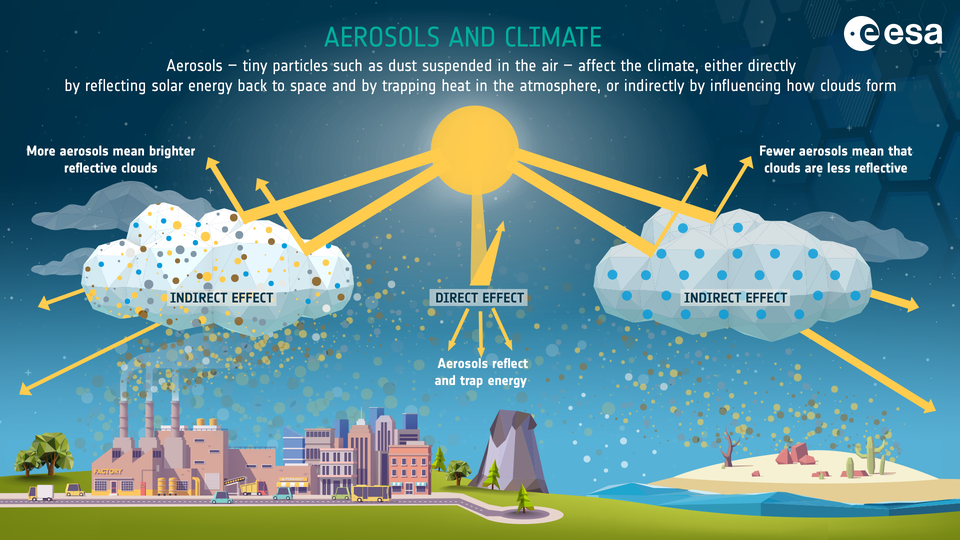
Smoke is one type of aerosol. Aerosols are tiny solid or liquid particles suspended in Earth's atmosphere. These particles can vary in colour, size, composition and origin.
 While it goes without saying that aerosols can affect the air we breathe, they play a significant role in Earth's climate system, both ‘directly’ by reflecting and absorbing incoming solar radiation and trapping outgoing radiation, and ‘indirectly’ as they may act as nuclei for cloud formation – which is how they influence our climate the most.
ESA’s Director of Earth Observation Programmes, Simonetta Cheli, noted, “I would like to send my congratulations to all those that have been involved in developing this remarkable Earth Explorer satellite over the years.
“It is not only the largest Earth Explorer mission we’ve ever developed, but it’s also the most complex. Anybody who wishes, can now start reaping the benefits of the years of work that have been put into this extraordinary satellite as the data is freely available with open access to all.
“We now look forward to seeing how using the data will result in new scientific findings about the changing atmosphere, particularly against the backdrop of the climate crisis.”
EarthCARE Level-1 data is available at the ESA Online Data Dissemination website. Users simply need to create an account to access the data freely.
Alternatively, a Level-1 data collection is available on the ESA Earth Online website.
In addition, the EarthCARE Product Data Handbook is also available.
Source:
European Space Agency. (2025, January 16). EarthCARE goes live with data now available to all. ESA Observing the Earth.
