Publié le 19 mars 2026
Ice sheet evolution is the key unknown in future sea level projection. Numerical models are the best way to assess ice sheet response to future changes in ocean and atmosphere. Observations of recent ice sheet change play a critical role in improving the accuracy of these models. The current revolution in our ability to observe ice sheets from space offers new possibilities for combining models and observation, and thus for improving projections of future sea level change.
A new study, published last week in Geophysical Research Letters, highlights how calibrating models with observation of changes in ice sheet surface dramatically improve the predictive power of the models. By applying such methods to the Thwaites glacier in Antarctica, one of the world’s most dangerous glacier for sea level rise, the research predicts that, in 40 years, the loss from Thwaites will almost equal the one from all of the Antarctica today.
A more accurate picture of glacier change
The research, funded in the context of the ESA Polar Science Cluster 5D Antarctica research project, is focusing on the western portion of Thwaites, which is thought to hold the key to the future of the sector. To forecast the mass loss, the researchers tested two independent ice sheet models, and trained them using two types of observation: velocity change from satellite interferometry; and elevation change from combined observations of four different altimetry missions. The use of velocities is standard in ice-sheet calibration; altimetry is not.

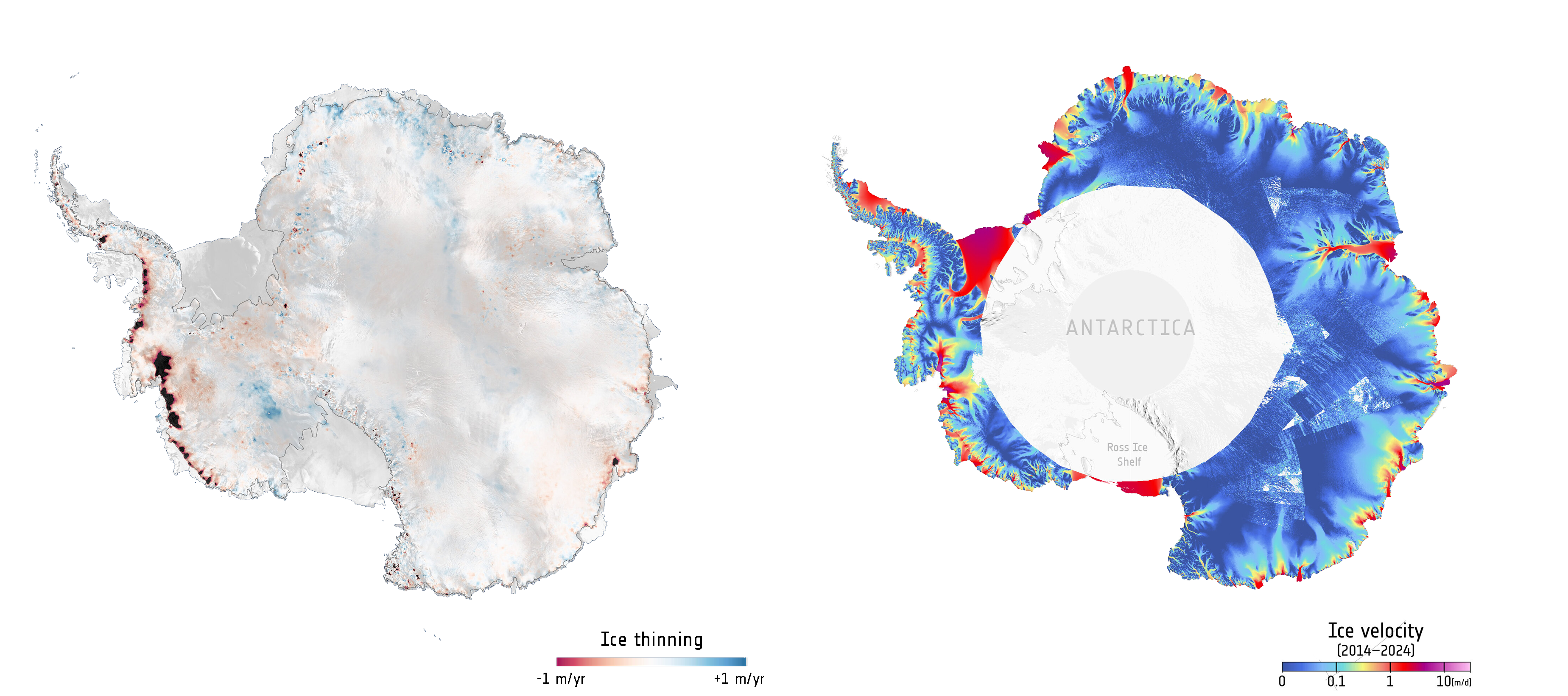
Antarctic-wide ice thinning (credit: CPOM/Leeds/ESA) and ice velocity (credit: ESA (Data source: Wuite, J. et al. 2025)).
The findings of this study indicate that calibrating the model exclusively with surface elevation change observations yields predictions of volume change rates that are ten times more accurate (over the validation window) compared to all other experiments and also improves consistency between the two models used.
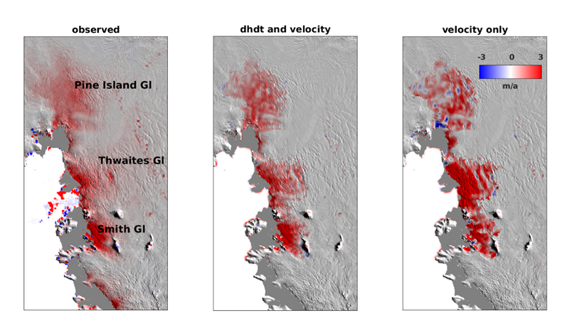
The observed thinning in recent years in the Amundsen Sea Embayment (left, meters per year). When the model is calibrated using velocities only (right), some areas thin too much (such as Smith and Thwaites Glacier) and some instead thicken (such as Pine Island). By using surface elevation constraints as well (centre), the model has the correct thinning trends, increasing confidence in future loss projections. Credit: CPOM, D. Goldberg (unpublished)
Dan Goldberg, from the University of Edinburgh and lead author of the study explained: “A common approach is to take an image of velocities, a ‘snapshot’, and ensure that the ice model matches it well at a single point in time. But the model then often has the wrong trends in thinning and acceleration. The method we use (Transient Calibration) allows us to use time-evolving observations – velocities AND surface thinning – which have ever-increasing availability and temporal extent. In our study, we find surface thinning to be more informational, but it really needs to be seen if this is true elsewhere in Antarctica, as well as in Greenland and in the large icecaps that can contribute to sea level. This will only happen through wider adoption of these methods, and availability of high-quality cryospheric data over long periods.”
Implications for sea level change
Importantly, the study predicts ice thinning spreading far inland along a deep valley beneath the glacier, potentially triggering runaway losses. Model training with Earth Observation dramatically affects predictions. Getting these forecasts right is crucial because Thwaites alone could raise global sea levels by over half a meter if it completely collapsed.
Noel Gourmelen, from the University of Edinburgh and co-author of the study explained: “Our ability to monitor the retreat of ice sheets and glaciers has been revolutionized by satellites observations. This research demonstrates the untapped potential of Earth Observation for improving our ability to project the future of ice sheets and their contribution to future Sea Level change. The research demonstrates that measurements from satellite altimeters can play a foundational role in the next generation of ice sheet model predictions.”
Upcoming Earth observation missions such as CRISTAL mission, designed to measure sea-ice thickness and ice-sheet elevation with unprecedented accuracy, will provide critical datasets to improve constraints on Antarctic ice-dynamics models.
Sources:
- European Space Agency (ESA). (2026, March 19). Satellite altimetry data confirms high mass loss from Thwaites glacier over next 50 years - eo science for society. EO Science for Society. https://eo4society.esa.int/2026/03/19/satellite-altimetry-data-confirms…
- Goldberg, D. N., Morlighem, M., & Gourmelen, N. (2026). Recent observations of Thwaites Glacier, West Antarctica are consistent with high rates of loss in next 50 years. Geophysical Research Letters, 53, e2025GL118823. https://doi.org/10.1029/2025GL118823