Publié le 28 août 2023
Confirmed by the World Meteorological Organization, July 2023 was the hottest month on record, with high-impact weather continuing through August. These records are based on air temperatures, but measurements of the temperature of Earth’s surface taken from space are also essential to tracking the impact of climate change, and to being better prepared for such extremes – especially when it comes to cities where stifling urban heat islands form.
The impact of climate change, affecting billions of people worldwide, is more severe and happening sooner than expected – with the United Nations Secretary-General António Guterres recently warning, “The era of global warming has ended, and the era of ‘global boiling’ has arrived.”
Rising global air temperatures are causing untold damage to the natural world and all of its inhabitants – our situation is clearly precarious.
There are many devastating issues related to climate change, but one is that temperature extremes directly affect the human body.
A paper, published in July in Nature Medicine, estimates that there were over 60,000 heat-related deaths in Europe between 30 May and 4 September 2022 – proof that extreme temperatures broke records last summer too.
According to the World Bank, 56% of the world’s population live in cities. They expect that the urban population will more than double by 2050, at which point nearly seven of ten people will live in cities.
Living in a city during a heatwave is particularly dangerous as people have to deal with what is known as the urban heat island effect.
Urban heat islands occur when natural land cover, such as vegetation, is replaced with buildings, roads, pavements and other surfaces that absorb and re-emit the Sun’s heat more than natural landcover such as forests and water bodies.

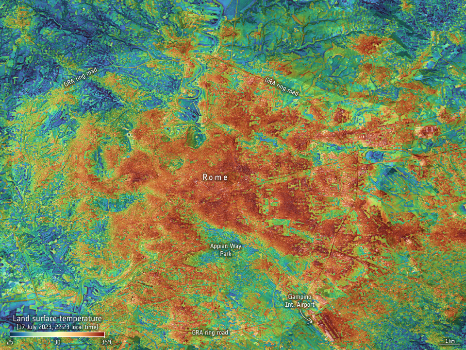
Land-surface temperature in Rome on 17 July 2023
click here to view the image at full resolution
Urban areas become ‘islands’ of higher temperatures compared to outlying rural areas. The difference between urban temperatures and rural temperatures tends to be more pronounced at night.
Here, measurements of land-surface temperature are important to understand and monitor urban heat islands, and to plan mitigation strategies to reduce the effects of this phenomenon.
It is worth noting the difference between air temperature and land-surface temperature.
Air temperature, given in our daily weather forecasts, is a measure of how hot the air is around 1 m above the ground. Land-surface temperature instead is a measure of how hot the actual surface would feel to the touch. During heatwaves the temperature of the surface tends to be hotter than the temperature of the air.
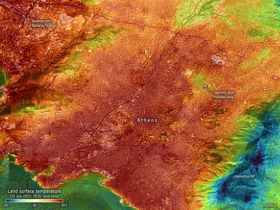
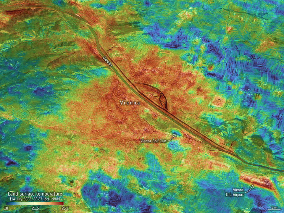
Images of night-time surface temperatures, taken in July by an instrument called Ecostress on the International Space Station show the land-surface temperature of Athens, Rome and Vienna in the evening or night-time on different dates in July 2023.
Measured on 15 July at 20:02 CEST, the surface temperature across the city of Athens is much the same – around 35°C. In comparison, the cooling effects of vegetation in Rome is clear to see.

Land-surface temperature in Athens on 15 July 2023
Full resolution image
The Ecostress instrument, owned by NASA’s Jet Propulsion Laboratory, is important because it is helping in the development of a new Copernicus Sentinel Expansion satellite – the Land Surface Temperature Monitoring (LSTM) mission – so images such as these offer a glimpse of what the new mission will deliver operationally.
ESA is using the experimental instrument to simulate the data that will eventually be returned by LSTM, which will provide systematic high-resolution measurements of the temperature of the land surface.
The mission promises to be a game-changer for urban planners in their efforts to improve the lives of city dwellers as climate change tightens its grip even more.
Both space agencies, NASA and ESA, are working together closely to make the most use out of the upcoming high-resolution thermal Earth observation missions in a synergetic manner, including NASA’s Surface Biology and Geology mission.
ESA’s LSTM mission scientist Benjamin Koetz said, “Knowing exactly how high the temperature a surface reaches and where the heat is being trapped will help planners make informed decisions for mitigating the heat impacts by where best to plant shading trees, use special cooling coatings for pavements or even roofs.
“We currently have Copernicus Sentinel-3, which already gives us land-surface temperatures, but LSTM will provide land-surface temperatures at higher resolution for urban planning – and importantly it will also give us these operational data products at night when the urban heat islands are at their worst.”
ESA’s Green Transition Information Factory – an online platform providing actionable information from Earth observation to accelerate the Green Transition for both society and the economy – is helping decision makers use information from space to adapt to climate change impacts.
Through its interactive platform, users can not only explore land surface temperatures across Austria, but they can also map and quantify the presence of green roofs on buildings.
Green roofs are an effective measure in mitigating the impacts of urban heat islands owing to their significant cooling power through increased evapotranspiration of plants. They are also able to decrease the energy consumption of buildings and sequester carbon within the plants and soil needed for the greening of roofs.
The platform’s ability to map green roofs in a given area provides valuable insights into their impact to mitigate the urban heat island effect as well as helping cities to plan further mitigation measures to prepare for extreme heatwaves in the future.
The Green Transition Information Factory is preparing for the Space for Green Future Accelerator – one of ESA’s Accelerators driving Europe’s innovation and the use of space for the global climate crisis.

Land-surface temperature in Vienna on 14 July 2023
Full resolution image
Source:
European Space Agency. (2023, August 24). Sensing city night heat from space.