Context and objectives
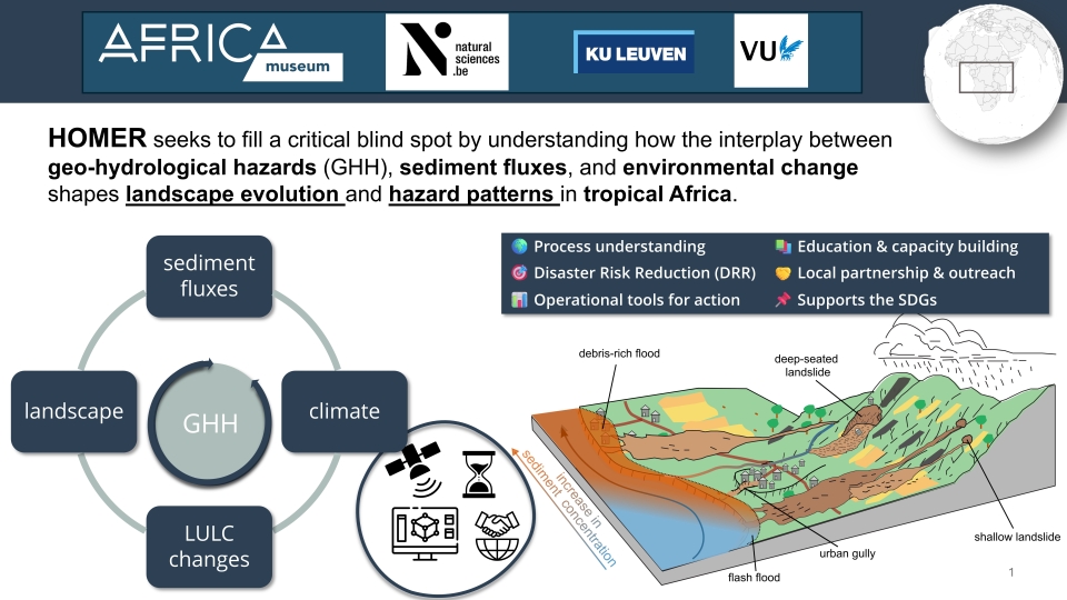
Geo-hydrological hazards (GHH) – shallow and deep-seated landslides, flash floods , and urban gullies – are major drivers of sediment transfer in tropical Africa, yet they are typically studied in isolation and their geomorphic role remains poorly quantified. HOMER addresses this gap by providing the first integrated, decadal-scale analysis of the full GHH spectrum and its impact on sediment dynamics across the western East African Rift (wEAR) and 26 DR Congo cities. The project exploits over a decade of Copernicus Sentinel data combined with state-of-the-art Earth observation workflows, advanced modelling, field campaigns, and strong partnerships with local institutions. Four specific objectives structure the work: (SO1) compile comprehensive multi-temporal GHH inventories; (SO2) characterise GHH frequency-magnitude, dynamics, and interactions; (SO3) quantify sediment fluxes from hillslope to river/lake systems; (SO4) assess land-use and climate drivers of GHH occurrence and dynamics.
Project outcome
Expected scientific results
HOMER will deliver:
-
a ten-year spatio-temporal inventory of shallow landslides and flash floods across the wEAR (2017–2027);
-
a ten-year inventory of ~300+ active slow-moving deep-seated landslides;
-
the first automated ten-year inventory of urban gully expansion dynamics for major DRC cities;
-
a large-scale landscape recovery dataset using spectral indices;
-
a multi-temporal suspended sediment concentration dataset from satellite water colour remote sensing in the wEAR;
-
a calibrated landscape evolution model (HyLands) providing benchmark erosion rates and landslide recurrence intervals;
-
data-driven models simulating landslide dynamics and urban gully expansion at event timescales;
-
unique geochronological records (10Be/14C) constraining long-term denudation rates in a tectonically active rift context.
Expected products and services
- Open-access datasets (Zenodo, CC BY): ten-year GHH inventories (SL, FL, SML, UG), landscape recovery maps, SSC time series, UAS-derived DEMs.
- Transferable and scalable EO processing chains for the full GHH spectrum in tropical environments (GitHub).
- Calibrated landscape evolution model (HyLands) adapted for cascading GHH and sediment dynamics.
- First data-driven model for urban gully expansion at event timescale.
- Risk-relevant outputs disseminated to DRC civil protection, Ministry of Mines, and Belgian diplomatic network.
- Contributions to the CIRRINA GHH risk information centre (Bukavu).
- Project website, GEO-WEBINAR series, social media outreach (LinkedIn, BlueSky), and public museum talks.
| Project leader(s): | MRAC/KMMA - Natural hazards and cartography | |||||
| Belgian partner(s) |
|
|||||
| International partner(s) |
|
|||||
| Location: |
Continent:
Country:
Region:
|
|||||
| Website: | https://georiska.africamuseum.be/en/activities/homer | |||||