Context and objectives
Polar-orbiting multispectral ocean colour sensors such as MODIS-AQUA and ENVISAT-MERIS have become well-established sources of chlorophyll a data for the global oceans and for coastal zones. While significant further progress can still be expected for polar-orbiting multi- or hyper-spectral ocean colour sensors, two major limitations have been identified:
1. Cloudiness and/or sunglint in many regions reduces the data availability from typically once per day (e.g. mid-latitude MODIS-AQUA) to significantly less. Applications, such as Harmful Algae Bloom detection, built on ocean colour data have critical vulnerability to such data gaps.
2. Processes in many coastal regions have significant variability at time scales shorter than the daily sampling frequency of wide swath polar-orbiting sensors.
Optical remote sensing from geostationary sensors has the potential to:
- increase very significantly the availability of data during periods of scattered clouds, and
- provide information on processes occurring at subdiurnal time scales during cloudfree periods.
GEOCOLOUR had the general objective of improving marine optical products from the existing SEVIRI geostationary sensor and preparing the next generation of geostationary ocean colour sensors.
Project outcome
The advantages of geostationary remote sensing were clearly established:
- Cloud-free data availability for the North Sea increases from about 100 days/year for a polar-orbiting sensor with daily passage to about 200 days/year for a geostationary sensor with hourly imagery from 10:00 to 16:00 UTC.
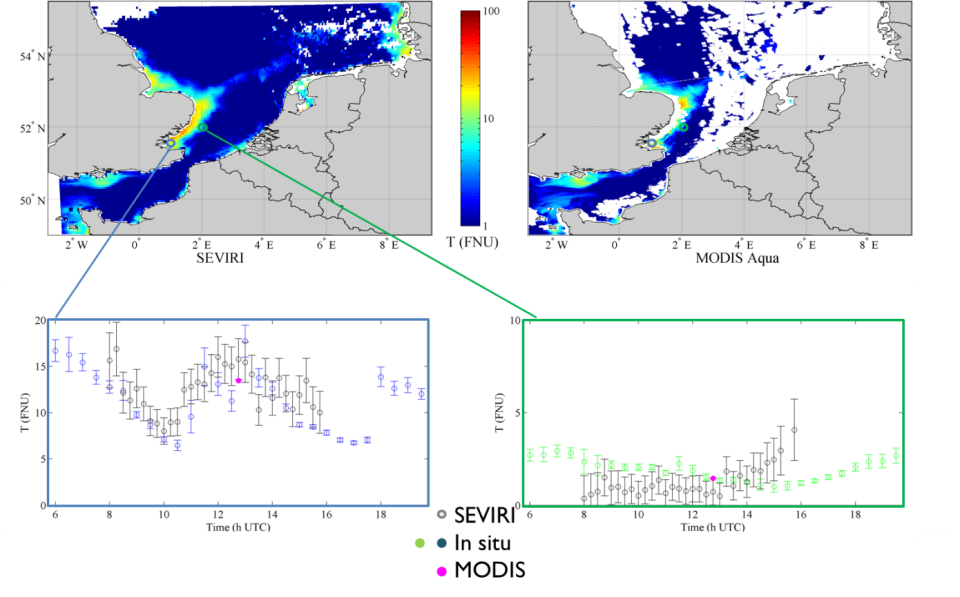
- Analysis of SEVIRI data also demonstrates the capability of resolving high frequency process such as tidal variability of suspended particulate matter in the North Sea.
- Analysis of GOCI data in the Bohai Sea further demonstrates the potential of using geostationary data for improving quality control of ocean colour data.
- The prototype SEVIRI image processing chain was improved and generalised to other regions.
- Geostationary/polar-orbit synergy products were developed and tested including a MODIS/SEVIRI reflectance/turbidity/Total Suspended Matter product.
- Reconstruction of complete TSM fields were generated from partially cloudy SEVIRI imagery using the DINEOF (geostatistical) analysis, demonstrating the feasibility of using DINEOF for tidal variability.
- A product was developed to represent the daily average of diffuse attenuation coefficient of photosynthetically available radiation (PAR) and the advantages of geostationary imagery for estimating surface PAR were demonstrated.
| Project leader(s): | IRSNB/KBIN - Directorate Natural Environment - Ecosystems data processing and modelling | |||||
| Belgian partner(s) |
|
|||||
| International partner(s) |
|
|||||
| Location: | ||||||
| Related presentations: | ||||||
| Related publications: | ||||||
| Website: | http://www.odnature.be/geocolour/ | |||||