Published on 15 January 2020
Moisture and organic matter content are essential soil properties. They control, at different scales of the soil-plant-atmosphere system, key hydrological processes, plant growth, contamination of surface and subsurface water and the sustainability of natural ecosystems. They therefore also influence biodiversity and are important links in the climate system.
Optimal and sustainable management of soil and water resources therefore requires knowledge of the dynamics of soil moisture and organic matter.

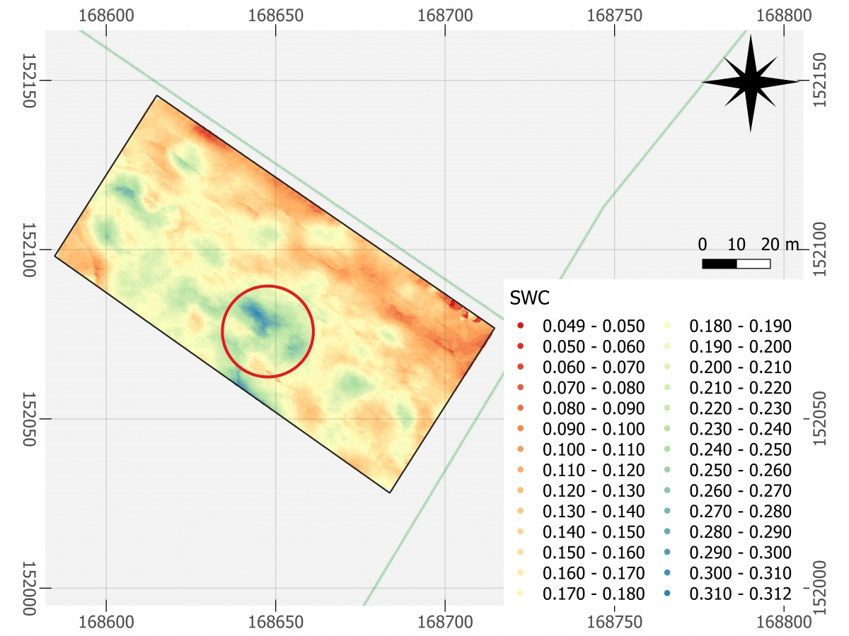
Drone-GPR flying over an agricultural field for soil moisture mapping. The area marked by a red circle corresponds to the area delineated in the 2 maps below.
The recent emergence of drones has opened up new avenues of research and application for digital soil mapping and plot monitoring for agricultural management. Within the STEREO project RAPAS, researchers from UCL and CSL have developed new drone detection methods for mapping the main soil properties with high spatial resolution.
They have developed a new lightweight ground-penetrating radar (GPR) and advanced radar signal processing methods for soil moisture mapping. In a context of precision agriculture, this technology is expected, among others, to improve the efficiency of irrigation practices by adapting the applied water quantity to the crop needs.
 |
 |
Soil moisture map derived from the drone-GPR measurements (left) and soil elevation map (right)
At the same time, new multispectral processing methods were developed and analyzed to retrieve soil organic carbon. A series of multispectral cameras were tested and compared. Particular attention was dedicated to positioning of the measurements and the cm accuracy was reached without the use of any ground control points. The GPR and multispectral tools that we developed were applied in a series of agricultural fields in the Belgium loess belt.
 |
|
Comparison of the drone-GPR (left) and Sentinel-1 data (right) for soil moisture
These soil moisture results were then compared to Sentinel-1 acquisitions. The results show that the spatial resolution of the satellite does not allow to detect the often very local variations of soil moisture in our fields.
More information
Projet RAPAS (Close range aerial sensing of soils for improved remote sensing products)
RAPAS project's partners: Sébastien Lambot (GPRLouvain, Earth and Life Institute, Environmental Sciences, UCLouvain), Kristof Van Oost (Earth and Life Institute, Earth and Climate, UCLouvain), Anne Orban (Signal Processing Services, Centre Spatial de Liège).