Gepubliceerd op 26 november 2023
Altimetry data delivered by Copernicus Sentinel-3 are enhancing our understanding of interactions between inland water, the coastal zone and the open ocean, as set out by an ESA-funded project.
Accurate monitoring of variations in global surface water is important for understanding the impacts of human-induced climate change. Water level estimates are also key to managing emergency responses to flooding and drought. While in situ hydrology sensors provide near real-time measurements, satellite altimetry products from Sentinel-3 of the European Copernicus programme complement in-situ measurements in many applications.
In the ESA-funded HYDROCOASTAL project - initiated within ESA’s Earth Observation (EO) Science for Society - algorithms were developed to further improve the processing of Sentinel-3 Synthetic Aperture Radar (SAR) altimetry data.
The main aim of the project was to maximise the exploitation of altimeter measurements in the coastal zone and inland waters. This application aimed to further understanding of interactions between the inland water and coastal zone, between the coastal zone and the open ocean, and the small-scale processes that govern these interactions.
Nadir altimeter acquisitions for hydrology
Copyright:OLTC web portal @ https://altimetry-hydro.noveltis.fr/
High resolution SAR altimetry datasets
David Cotton, Project Manager for the HYDROCOASTAL project, says, “Altimetry data from Sentinel-3 are providing a step-change in the way we can monitor coastal and inland waters, in terms of the resolution we can achieve and the accuracy of water level measurements. With advanced processing there is scope to achieve even higher resolution datasets.”
At the start of the project, six innovative SAR altimeter processing algorithms were implemented and evaluated, with an initial test dataset focusing on performance at the coast and over inland waters. The best performing algorithms were selected to generate global scale coastal zone and inland water products in the second year of the project.
The HYDROCOASTAL project has recently released this product, covering 25 regions, including water level and river discharge time series for nineteen inland water regions, as well as several coastal regions.
Exploiting altimetry in coastal and inland waters
“Our goal was to improve the processing of Sentinel-3 SAR altimetry data, taking advantage of the fact that with SAR altimetry, there is a much higher resolution and more accurate range measurements. In SAR mode, the return signal reflected from the ground can be further sub-divided, so that you can achieve resolution of a few hundred metres along track. With advanced processing methods, this resolution can be improved to tens of metres,” says Cotton.
The final HYDROCOASTAL product is now freely available upon request, containing Level-2 outputs from the selected algorithms over 25 regions. There are also Level-3 time series and Level-4 river discharge datasets for medium to large rivers, an experimental small rivers data set, and an additional small coastal dataset produced by project partner, isardSAT, generated by their Coastal and Fully Focused SAR Processors.
Tracking sea level anomalies and hydrological forecasting
The benefits of these datasets have been investigated through a series of impact assessments, with case studies monitoring various coastal zones and estuaries, including the Bristol Channel in the UK, the Venice Lagoon (Italy), the Southern North Sea and the South-Western Baltic Sea. Commonalities across all these locations include vulnerable coastal habitats, risk of erosion and flooding, as well as a connection between river discharge and coastal sea levels.
Along track sea level anomaly profiles from HYDROCOASTAL datasets were used to analyse river levels during droughts of the Po River in Italy, indicating saline water intrusion up-river. The data have also been used to investigate the impacts of lake size and riverbank configuration on the accuracy of water level retrievals in both Irish and Siberian rivers. Inland case studies of river systems in China show the potential of developing an operational hydrological forecasting system.
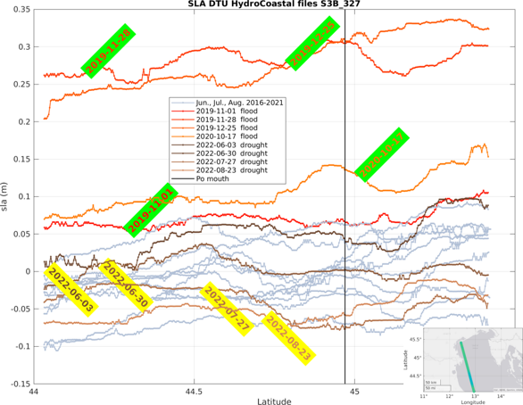
Sea level anomaly profiles from Sentinel 3-B just offshore from the River Po Outlet
Copyright:ESA/European Union, Copernicus Sentinel-3
The Copernicus Sentinel-3 Hydrocoastal products have been validated against measurements from in situ hydrology sensors, with the added advantage of their ability to monitor remote areas where in situ measurements are lacking. External end-users are encouraged to access these new data products, and evaluate and implement them in their own applications. More information is available on the HYDROCOASTAL project page here.
Preparing the future of altimetry over Inland waters
Since monitoring rivers and lakes is of high importance for EO scientists, for the European Commission and the Copernicus Services, hydrology has been identified as a secondary mission objective for Copernicus Polar Ice and Snow Topography Altimeter (CRISTAL) mission. Hydrology has also been elevated as a primary objective for the Sentinel-3 Next Generation Topography (S3NG-TOPO) mission.
S3NG-TOPO will address the need for improved altimeter sampling and timely delivery of data. It will build on current Sentinel-3 research and development projects, such as HYDROCOASTAL, while incorporating advanced technologies and configurations to meet the evolving requirements of global ocean monitoring and hydrological applications.
By combining data from both S3NG-TOPO companion satellites, unprecedented sampling of inland water bodies will be achieved, with near-real-time latencies of less than six hours, to better serve critical hydrology users and emergency services.
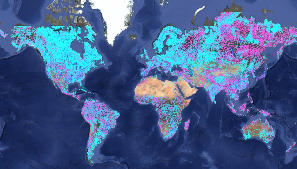
Improved S-3 altimetry data are also used to monitor worldwide the water level of rivers in near real time [2] . This is of particular importance for applications such as weather, flood, and drought forecasting.
![Near real-time altimetry for river monitoring—a global assessment of Sentinel-3Copyright:Jiang et al [2]](/sites/default/files/styles/xlarge/public/content/erlacdd16f4_hr.jpg?itok=8ATz8x8A)
Near real-time altimetry for river monitoring—a global assessment of Sentinel-3
Copyright:Jiang et al [2]
Recently, a full mission reprocessing campaign has been completed for Sentinel-3, generating new Level-2 Hydro-Cryo thematic products over inland waters, sea ice and land ice. Another ESA- and EU-funded project, the St3TART (Sentinel-3 Topography mission assessment through reference techniques) project aimed at producing Fiducial Reference Measurements (FRM) for Sentinel-3 mission over inland water, sea ice and land ice surfaces. The continuation of St3TART will focus on the nominal operation and provision of FRMs in support of calibration and validation activities for radar altimeters, with a strong focus on hydrology.
The Altimeter Open Loop Tracking Command (OLTC) for Hydrology website allows exploration of more than 170 thousand hydrological targets worldwide, such as those from Sentinel-3A and -3B. The website is developed by NOVELTIS and CNES for ESA and allow any scientist to contribute to the maintenance of the Sentinel-3A, Sentinel-3B and Sentinel-6A OLTC database by proposing new targets over lakes and rivers.
The new generation of altimeters, such as the SRAL instrument onboard Sentinel-3, offer the potential to significantly improve data provision over inland waters and at the coast, as well as delivering higher resolution data along track. A recent comparison of multiple altimeters in monitoring mountainous Tibetan lakes, showed how new types of altimeters have improved performance compared to previous generations of radar altimeters.
Source:
Copernicus. (2023, November 24). Copernicus Sentinel-3 altimetry data boost hydrology studies. Sentinel Online: Sentinel Success Stories.