Gepubliceerd op 22 december 2023
Sensors on Copernicus Sentinel-3 that measure snow and ice properties, have been used to develop a fast and accurate approach for monitoring the extent of land ice melt, as set out in an ESA-funded research project.
Our climate crisis is transforming the frozen parts of Earth’s system, accelerating land ice mass loss, with complex ramifications, such as global sea level rise. Surface melting is thought to contribute to roughly half of Greenland’s ice sheet mass loss, and even more for smaller Arctic ice masses. A key mechanism in surface melting is changing surface reflectivity, or albedo – the fraction of light that is reflected off an ice sheet or snow-covered surface. As heat melts ice sheets or even removes surface snow, this decreases surface albedo, causing even more melting.
As well as measuring high resolution sea-ice thickness and ice sheet topography changes with a synthetic aperture radar altimeter, the Sentinel-3 satellites of the European Union’s Copernicus programme also host sensors enabling clear-sky sun-lit retrieval of snow and ice optical properties across Earth’s surface.
In the ESA-funded SICE project - initiated within ESA’s Earth Observation science for society and enhanced through the ESA Network of Resources initiative - the snow and ice optical properties (SICE) products from Sentinel-3 have been used to measure snow grain size and snow and ice spectral and broadband albedo.
Logo SICE
Bare ice and snow impurities, including those caused by biological effects, can reduce surface albedo. For over two decades, space-borne sensors have helped track changes in surface albedo, however, the Ocean and Land Colour (OLCI) instrument on Sentinel-3 provides new opportunities to measure satellite-derived albedo, with higher resolution (300 metres) and more spectral channels than the earlier multi-decade Earth Observation satellites.
Researchers from the Department of Glaciology and Climate at the Geological Survey of Denmark and Greenland (GEUS), in Copenhagen, in collaboration with researchers from France and Germany, have used Sentinel-3 OLCI data to develop an automated open-source processing chain to determine daily albedo of glaciated areas. The processing chain can also be applied to other surface properties, such as dry and wet snow or bare ice spectral albedo.
The team have successfully used the SICE software to retrieve snow properties over Greenland and examine snow pollution in the interior of the Antarctic ice sheet [1]. Results were validated using ground-based observations both for polluted and clean snow cases.
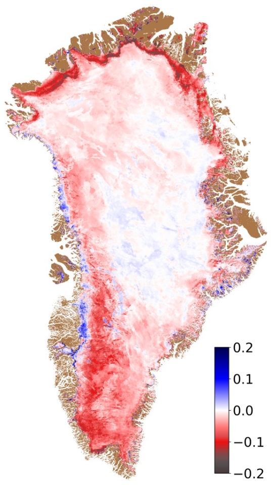
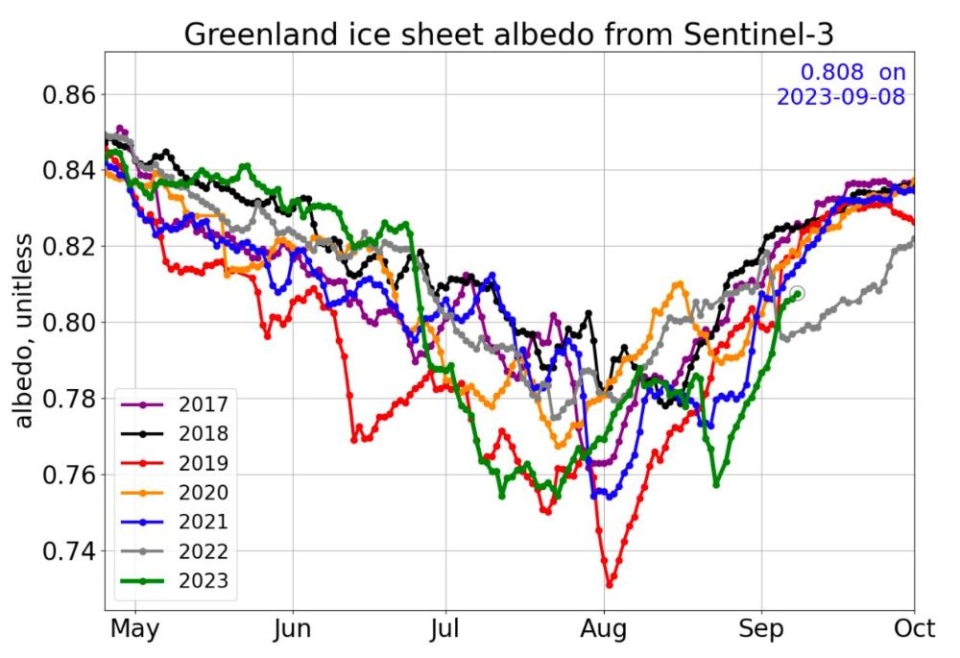
Abnormal July 2023 warmth caused albedo anomalies across Greenland ice sheet
Copyright:ESA SICE project
In 2021, rainfall was witnessed for the first time near the highest point of the Greenland ice sheet due to a heatwave, driven by an atmospheric river. This heatwave caused extreme ice sheet snow cover changes. There were albedo feedback impacts – as the heat darkened the snow and exposed bare ice, more melting occurred. Satellite retrievals of SICE albedo from Sentinel-3A were used to successfully map the amplified surface melting during the heatwave [2].
The researchers have also shown this method based on using spaceborne optical observations can map snow cover at much finer resolutions than conventional passive microwave satellite remote sensing [3]. With a more mature albedo retrieval algorithm the SICE toolchain can also be applied to track sea ice, as well as land ice [4].
Research lead, Prof. Jason E. Box, from the Geological Survey of Denmark and Greenland, says, “It’s a proud moment, with OLCI on Sentinel-3 carrying the torch from earlier sensors, to deliver a high accuracy and low latency cryosphere monitoring albedo product. As these Arctic and Antarctic land ice optical properties are assimilated into climate reanalyses, we are increasing the societal service of Earth observation.”
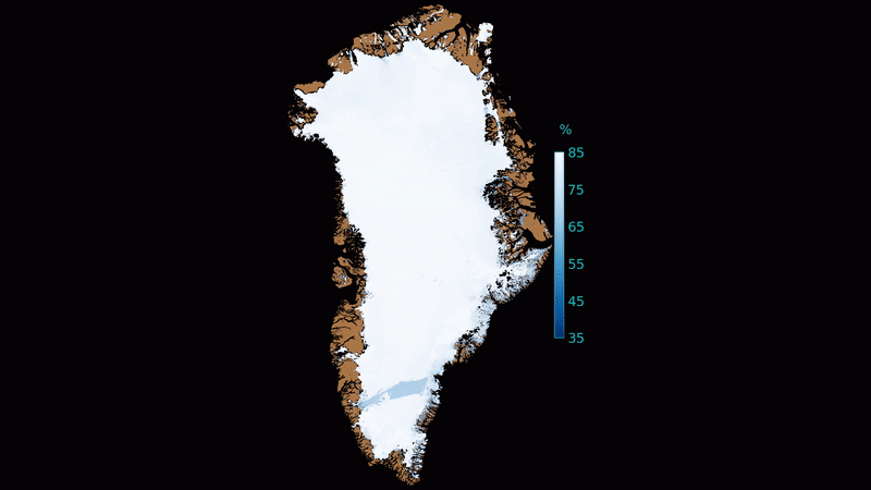
Abrupt Greenland ice sheet darkening, July 2023
Copyright:ESA SICE project
The team have been able to demonstrate operational near real-time (under six hours latency) capability for Sentinel-3A cryosphere optical retrievals and SICE retrievals have been incorporated into the Danish Meteorological Institutes operational NRT processing, since September 2023.
The SICE products currently available include broadband albedo of snow or bare ice areas, snow grain size and top and bottom of atmosphere reflectance in all 21 OLCI bands. For these variables, daily mosaics spanning 2017 to 2023 are available at 1 km grid spacing for ten Arctic land ice areas, including: Greenland, Arctic Canada, Alaska & Yukon, Svalbard, Novaya and Severnaya Zemlya, Frans Josef Land and Iceland. The products can be accessed anonymously through the GEUS dataverse and the GEUS THREDDS server.
A heatwave produced extreme low Greenland ice sheet albedo ~14 July, 2023
Copyright:ESA SICE project
About the Copernicus Sentinels
The Copernicus Sentinels are a fleet of dedicated EU-owned satellites, designed to deliver the wealth of data and imagery that are central to the European Union's Copernicus environmental programme.
The European Commission leads and coordinates this programme, to improve the management of the environment, safeguarding lives every day. ESA is in charge of the space component, responsible for developing the family of Copernicus Sentinel satellites on behalf of the European Union and ensuring the flow of data for the Copernicus services, while the operations of the Copernicus Sentinels have been entrusted to ESA and EUMETSAT.
Did you know that?
Earth observation data from the Copernicus Sentinel satellites are fed into the Copernicus Services. First launched in 2012 with the Land Monitoring and Emergency Management services, these services provide free and open support, in six different thematic areas.
The Copernicus Land Monitoring Service (CLMS) provides geographical information on land cover and its changes, land use, vegetation state, water cycle and Earth's surface energy variables to a broad range of users in Europe and across the World, in the field of environmental terrestrial applications.
It supports applications in a variety of domains such as spatial and urban planning, forest management, water management, agriculture and food security, nature conservation and restoration, rural development, ecosystem accounting and mitigation/adaptation to climate change.
Whereas the Copernicus Climate Change Service (C3S) supports society by providing authoritative information about the past, present and future climate in Europe and the rest of the World.
Source:
Sentinel Online. (2023, December 19). Copernicus Sentinel-3 proves instrumental in tracking melting land ice - Sentinel Success Stories - Sentinel Online. Sentinel Success Stories.