Gepubliceerd 4 dagen ago
When Anak Krakatau erupted in early September, ESA’s EarthCARE satellite provided something most satellite images cannot: a vertical cross-section through the volcanic plume. Its observations helped aviation experts determine how high ash and gases had reached and where aircraft should avoid flying.
Volcanic ash is a serious hazard to aviation because it can damage aircraft engines and reduce visibility, while gases such as sulphur dioxide can also affect cabin air. During the eruption, the Darwin Volcanic Ash Advisory Centre added data from EarthCARE’s atmospheric lidar, ATLID, to its operational monitoring tools.
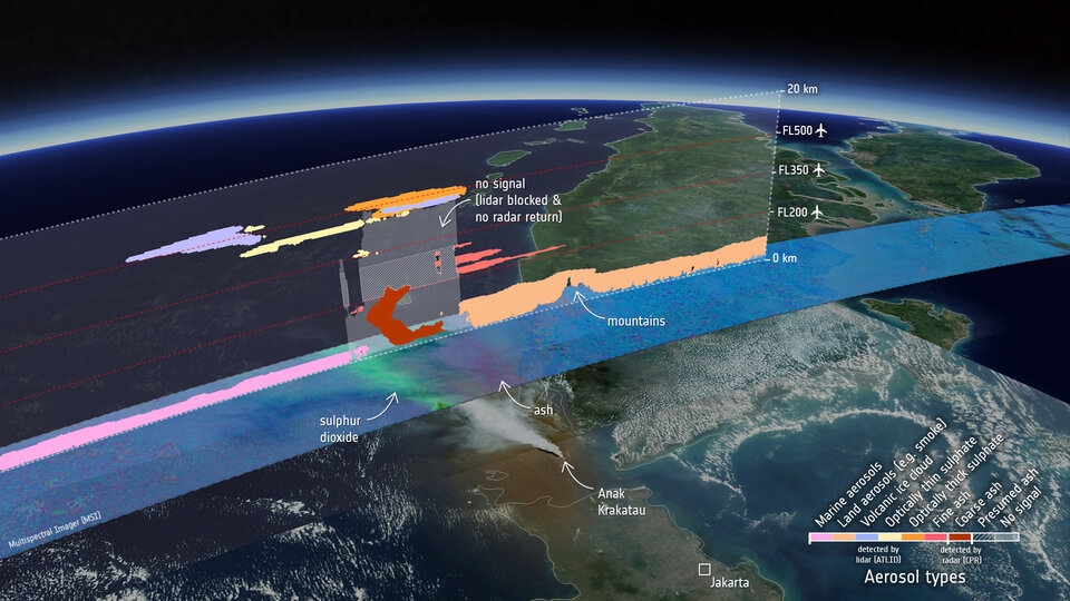
EarthCARE observed the Anak Krakatau plume on 5 September 2026, revealing layers of ash, sulphate and other aerosols at different altitudes. The visual combines Copernicus Sentinel-3 imagery with measurements from EarthCARE’s imager, lidar and cloud-profiling radar, alongside typical aircraft flight levels.
Image: ESA, using Copernicus Sentinel-3 and EarthCARE data
EarthCARE detected the plume as a complex stack of different aerosol layers. Its measurements helped forecasters confirm an upper component of the plume at around 15 km altitude, while the satellite’s radar also picked up what may be larger ash particles extending from near the surface to about 6 km.
The observations are valuable beyond the immediate aviation warning. Knowing how high volcanic material is injected into the atmosphere, how quickly it settles and how far it travels also helps scientists understand how eruptions can influence climate and Earth’s radiation balance.
Based on: European Space Agency (ESA), EarthCARE’s view of volcanic plume boosts air safety, 1 October 2026.