Gepubliceerd op 30 november 2022
In December 2022, Earth was in the grips of La Niña—an oceanic phenomenon characterized by the presence of cooler than normal sea-surface temperatures in the central and eastern tropical Pacific. The current La Niña, relatively weak but unusually prolonged, began in 2020 and has returned for its third consecutive northern hemisphere winter, making this a rare “triple-dip” event. Other triple-dip La Niña’s recorded since 1950 spanned the years 1998-2001, 1973-1976, and 1954-1956.
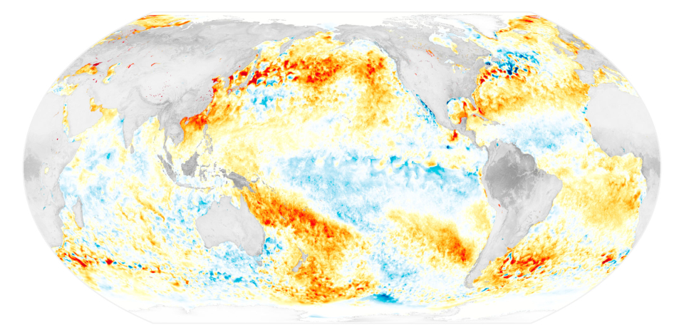
The map above shows sea surface temperature anomalies on November 29, 2022. The signature of La Niña is visible in the central and eastern Pacific Ocean as areas of cooler-than-average water. From the South American coast to the international dateline, surface waters on this day were roughly 1°C (1.8°F) cooler than usual.
Water temperature anomalies that range from -0.5°C to -0.9°C are classified as a “weak” La Niña, -1°C to -1.5°C are “moderate,” and -1.5°C and beyond are “strong.” The data are from the Multiscale Ultrahigh Resolution Sea Surface Temperature (MUR SST) project. MUR SST blends measurements of sea surface temperatures from multiple NASA, NOAA, and international satellites, as well as ship and buoy observations. (Scientists also use instruments floating within the sea to project underwater temperatures.)
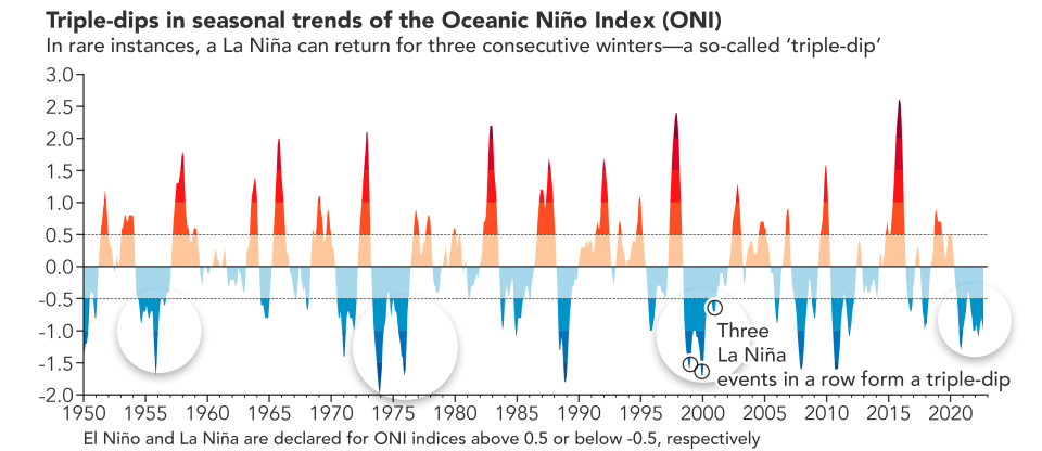
“Triple-dip” La Niña events take the name from the seasonal dips that show up in charts of La Niña’s strength. Dips typically occur around December when water reaches its coolest. The Oceanic Niño Index (ONI) chart above is a three-month running mean of sea surface temperature anomalies in a patch of the topical Pacific used for monitoring La Niña (and El Niño) conditions.
Much like El Niño, La Niña events affect weather across the globe. “When the Pacific speaks, the whole world listens,” explained Josh Willis, a climate scientist and oceanographer at NASA’s Jet Propulsion Laboratory (JPL). “Their strongest impacts are on either side of the Pacific Ocean. Floods in northern Australia, Indonesia and southeast Asia are common in La Niña years, as is drought in the American southwest.” Meteorologists have linked the current La Niña to a variety of natural disasters, including drought and food security problems in the Horn of Africa, flooding in Australia, and drought in the U.S. Southwest.
Source
La Niña Times Three. (n.d.). https://earthobservatory.nasa.gov/images/150691/la-nina-times-three