Gepubliceerd op 27 oktober 2023
The authors hope the study will be the first step to developing a satellite-enabled early warning system for crop health that operates over regional and even national scales.
Led by the International Maize and Wheat Improvement Center (CIMMYT) at its site in Ethiopia, the research drew on imagery from the SkySat and Pléiades constellations, which were delivered via ESA’s Third Party Missions programme. These data were used alongside observations from uncrewed drones.

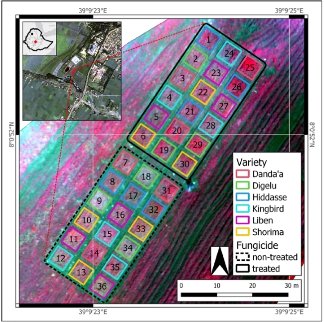
Field trial experimental set up
The project – completed in partnership with the Ethiopian Institute of Agricultural Research (EIAR) and New Zealand-based Lincoln Agriotech Ltd – focused on a group of fungal crop diseases called wheat rusts, which can destroy entire yields within a matter of weeks.
Consequently, wheat rusts are a major threat to agricultural production, particularly in Asia and Africa, where up to 25% of the world’s wheat is grown.
To help address this challenge, the research team built on past research that drew on remote sensing data to support detection and control strategies.
Gerald Blasch, Earth observation specialist at CIMMYT-Ethiopia and lead author of the study, explained: “Satellite data have been used to detect wheat rusts in previous study, but these investigations have tended to focus on crops in the later stages of growth, when the effects are clearly visible – unfortunately, by this point, it may be too late for control measures to be effective in reducing losses.
“In the current research, we aimed to detect more subtle signs of disease that manifest in earlier growth stages, giving farmers more time to apply fungicides and protect their crops. Very high resolution data from ESA’s Third Party Missions programme were vital in enabling us to achieve this objective.”
At EIAR’s Kulumsa Agricultural Research Center, Blasch and his team completed a field trial in which several varieties of wheat – with varying levels of resistance and susceptibility – were infected with yellow and stem rusts, and exposed to treated and non-treated fungicide regimes.
Disease development was assessed manually by plant pathologists at planned time points using visual estimations. These observations were compared with disease scores derived from data delivered by SkySat and Pléiades, as well as the uncrewed drone system, which overflew the study site at regular intervals.
SkySat and Pléiades were chosen for the study due to their capability to deliver highly detailed data over several spectral bands.
Operated by Earth observation data provider Planet, SkySat consists of 21 high-resolution satellites capable of sub-daily acquisitions of panchromatic and multispectral images, at spatial resolutions of less than 1 m. The multispectral imagery used in the project included blue, green, red and near-infrared bands.