Gepubliceerd op 5 april 2022
As part of ESA's Earth Online series on Thematic Areas, this article showcases the numerous ESA missions providing essential data to help keep watch on and protect our oceans.
Both active and non-operational Earth observation satellites are equipped with various microwave monitoring instruments, optical imagers, and infrared radiometers, which can map ocean variables related to ocean currents, sea ice and sea surface.
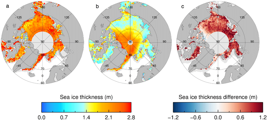
Sea ice thickness from Envisat and CryoSat when the missions were both operational. (a) Envisat sea ice thickness. (b) CryoSat sea ice thickness. (c) Sea ice thickness difference (Envisat minus CryoSat). The maximum ice extent mask for the common mission period is shown in light grey.
The data acquired by these many missions also support maritime security and marine environmental monitoring and are a vital tool for tracking climate change.
Using pioneering space technologies, the Earth Explorer family of research missions have long provided crucial ocean data. The first Earth Explorer, the Gravity Field and Steady-State Ocean Circulation Explorer (GOCE), used a state-of-the-art gradiometer to open a window into the currents circulating within the depths of oceans.
Although GOCE is no longer operational, its data are provided through ESA’s Heritage Space Program and continue to improve our understanding of ocean circulation, heat transport by ocean currents, as well as ice-sheet surface topography from altimetry.
Earth Explorers Boost Climate Research
Sea ice is formed from freezing ocean water and the behaviour of polar sea ice has a significant impact on global climate change. The CryoSat mission uses advanced synthetic aperture radar and interferometry techniques, to accurately monitor sea ice in polar regions.
The Soil Moisture and Ocean Salinity (SMOS) mission contributes to climate research by mapping ocean salinity—a key variable used in oceanographic and climate change models. Meanwhile, one of the lesser-known applications of ESA's three-satellite Swarm mission, which measures Earth’s magnetic field, is identifying ocean circulation using its magnetic signature.
New Possibilities With Third Party Missions
Through the Earthnet programme ESA facilitates data access from a plethora of Third Party Missions (TPM) many of which provide high resolution images, opening various possibilities for ocean water monitoring and maritime surveillance. For example, the spectral bands in mode 2 of the Compact High Resolution Imaging Spectrometer (CHRIS) onboard the PROBA-1 satellite, are designed for ocean water quality monitoring.
CHRIS reveals bountiful biophysical and biochemical data, essential for protecting valuable ocean resources and habitats.
Pléiades and Pléiades Neo are TPMs providing a number of high-quality data products, which can be used extensively in marine security. Pléiades provides 50 cm resolution and Pléiades Neo provides 30 cm resolution. The Pléiades images are ideal for identifying maritime activities and navigation, oil spill monitoring and illegal fishing.