Context and objectives
![]()
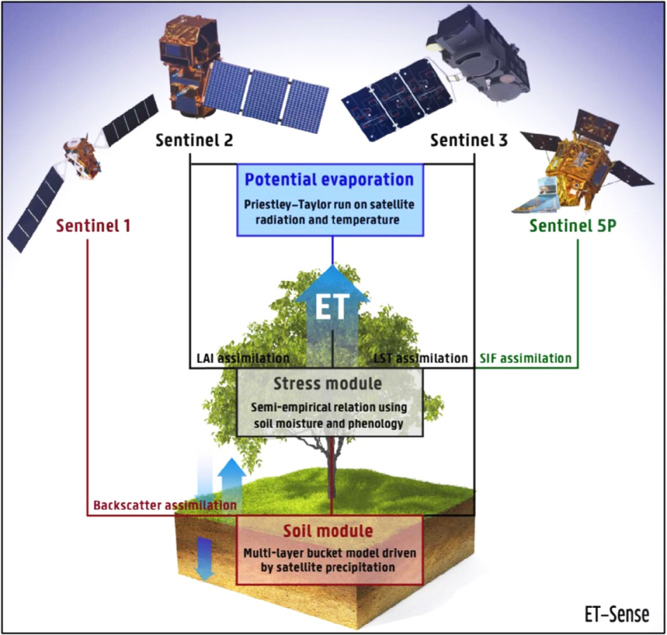
Terrestrial evaporation (E) is an essential component of the climate system that links the water and energy cycle. Field-scale E formulations driven by remote sensing data of radiation, temperature and environmental properties are commonly used to produce global E datasets. However, these global datasets cannot be easily downscaled to the resolution required for local or regional-scale studies, since the meteorological input variables they use are often very coarse. Given these constraints, the following research questions were addressed by ET–Sense: Can a state-of-the-art global remote sensing-based evaporation model be used to derive high-resolution estimates at continental scales?
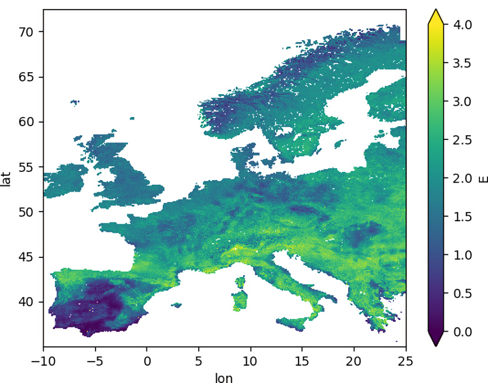
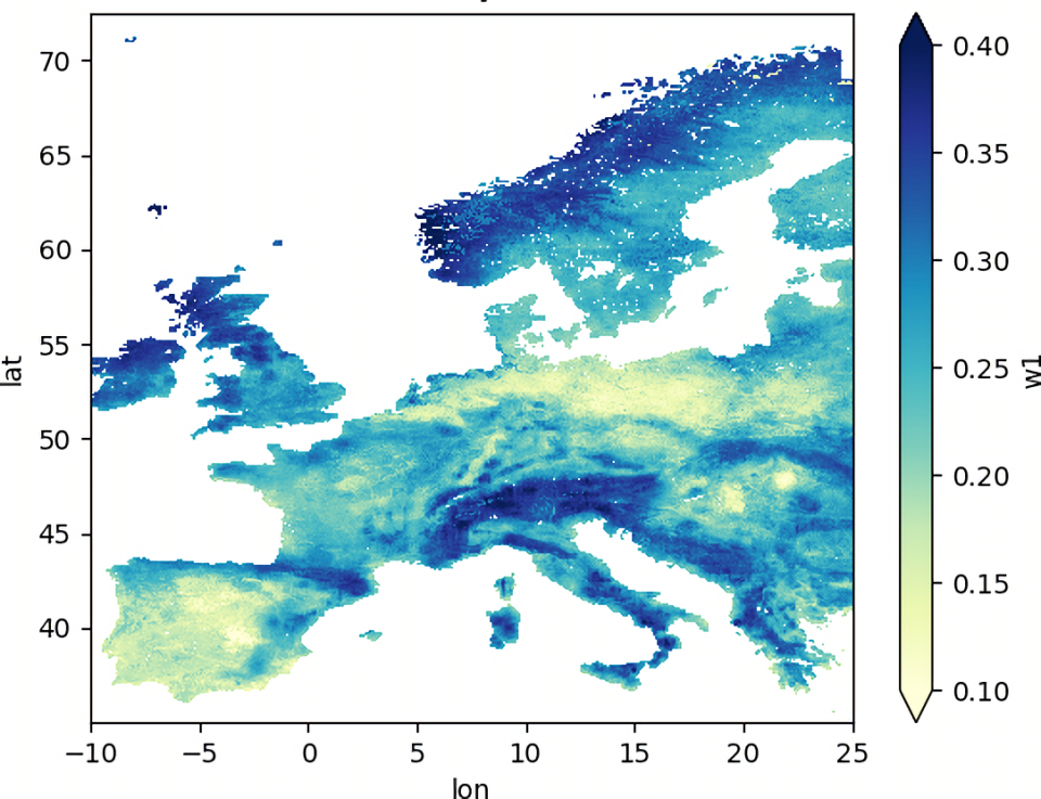
Can those estimates inform on the variability of root-depth soil moisture and evaporation to local stakeholders? Could these datasets be operationally produced? By adapting the Global Land Evaporation Amsterdam Model (GLEAM) to make use of the wide palette of Sentinel observations in a novel and innovative way, we aimed at producing, not just E, but also root-zone soil moisture data. This was done for the entire Europe at high spatial resolution (1 km) and at daily time scales. This is the first pan-European dataset of this nature and will allow us to bring recent research developments from the hydrology and climate community to the actual water management and agricultural needs.
Project outcome
Scientific results
A newly implemented Python version of the GLEAM land surface model has been developed which is suitable for the incorporation of high-resolution observations from the EU’s Sentinel satellite programme. The use of Sentinel 1, Sentinel 3 and Sentinel 5 has been explored both scientifically and pragmatically keeping the final objective in mind. Specific scientific output is linked to each separate use-case of Sentinel observations. The evaporation and soil moisture datasets were produced and validated, and they will be made public in due time. The net radiation and land surface temperature datasets will equally be made available with an intense validation being part of the accompanying publication.
The work carried out within ET–Sense has contributed to H-CEL being participant in the DTE–Hydrology, DTE–Hydrology Evolution and 4DMED–Hydrology projects funded by the European Space Agency, allowing for further optimisations and developments both for GLEAM itself and it making use of the Sentinel constellation. The dataset produced in ET–Sense and these projects will be used by the ESA funded Irrigation+ project. ET–Sense consolidated a close collaboration with the Dutch SME VanderSat with GLEAM now being a professionally maintained piece of software that is being commercialised when run at 100 metre resolution. The same software has been used for the updated publicly available global GLEAM dataset as well as the State of the Climate reports on evaporation (2020, 2021). Ongoing research making use of the ET–Sense findings is focused on even higher resolution simulations over agricultural areas using the results from the experiments using Leaf Area Index data from ProbaV and the Sentinel 1 assimilation study.
Societal (including environmental) relevance
High-resolution data of evaporation and soil moisture across Europe will benefit analysis of heatwaves, droughts, wet anomalies as well as improve the overall knowledge of the hydrological and climatic state of Europe. The high-resolution land surface temperature and net radiation forcing variables can be adopted by other research groups for analysis or modelling activities.
Products and services
High-resolution evaporation and soil moisture across Europe as an operational service as well as high-resolution land surface temperature and net radiation as a forcing variable.
Potential users
Scientists, water managers, policymakers, large-scale agricultural stakeholders, and the interested public.
Outreach
ET–SENSE: High resolution evaporation and soil moisture based on the Sentinel constellation
ET-Sense: evaporatie en bodemvochtigheid aan hoge resolutie op basis van de Sentinel-constellatie
ET-Sense : évaporation et humidité du sol à haute résolution basées sur la constellation Sentinel
| Project leader(s): | UGent - Hydro-Climate Extremes Lab (H-CEL) | |||||
| Belgian partner(s) |
|
|||||
| Location: |
Continent:
|
|||||
| Related presentations: | ||||||
| Website: | https://www.gleam.eu/ | |||||