Context and objectives
![]()
High-quality satellite-based ocean colour products can provide valuable support and insights in management and monitoring of coastal ecosystems. Today’s availability of Earth Observation (EO) data is unprecedented including traditional medium resolution ocean colour systems -S3plus- (e.g. MODIS-AQUA, Sentinel-3/OLCI), high resolution land sensors –S2plus- (e.g. Sentinel-2/MSI, Landsat-8/OLI, Pleiades) and geostationary satellites –GEO- (e.g. SEVIRI). Each of these sensors offers specific advantages in terms of spatial, temporal, or radiometric characteristics. With the availability of such multi-scale ocean colour products, the question arises on how to optimally integrate the multi-scale ocean colour data and generate advanced ocean colour products by adding value to products based on individual data streams. To integrate the multi-scale data products, we adapted the Data Interpolating Empirical Orthogonal Functions (DINEOF) technique originally developed to reconstruct missing data in geophysical data sets. To take advantage of the synergy between S3plus, S2plus and GEO sensors and integrate the data streams into a multi-scale ocean colour product, it is key to quantify the differences in their spatial, temporal and spectral characteristics and their impact on the quality of resulting ocean colour products. Combining this information into a complete uncertainty budget of the advanced multi-scale ocean colour product will facilitate the acceptance of these new products by end users (e.g. policy maker, modellers, etc.) and open up new applications of EO data.
Within the MULTI-SYNC project, we aim at performing the necessary research to develop advanced ocean colour products (i.e. remote sensing reflectance, turbidity, and chlorophyll a concentration) through synergetic use of multi-scale EO data taking advantage of spectral characteristics of S3plus sensors, the high spatial resolution of S2plus sensors and the high temporal resolution of GEO sensors.
Project outcome
Scientific results
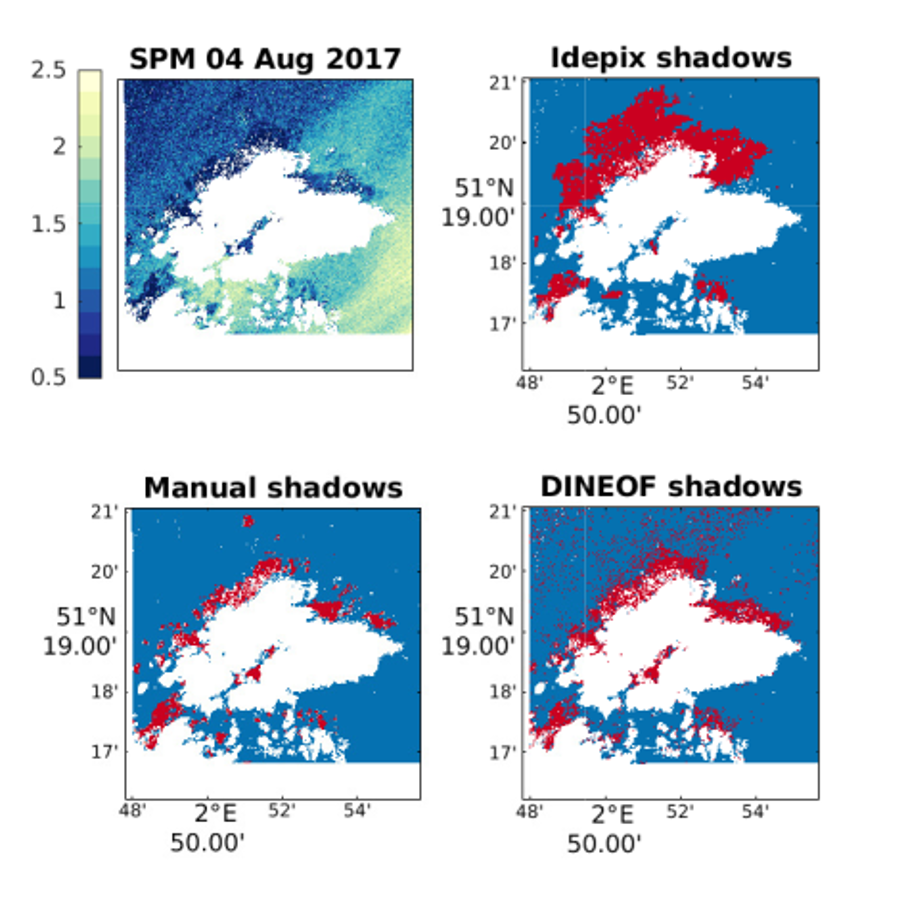
- Adaptation of DINEOF to high-resolution satellite imagery (e.g. Sentinel-2) including a novel approach to detect pixels affected by shadows independently from their size. Results show that the approach can detect between 66 and 85% of the shadows depending on the scene.
- Development of specialized set up of the high-resolution DINEOF in a cloud-based processing environment (i.e. CREODIAS) for big data processing to ensure reasonable NRT processing times for the CMEMS high-resolution service.
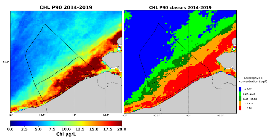
- Analysis of the temporal and spatial evolution of chlorophyll-a and suspended particulate matter have in the North Sea by means of a 23-year gap-filled dataset (1998-2020). The main results showed the spring bloom onset occurs approximately 1 month earlier in 2020 compared to 1998 due in part to the rising water temperature experienced globally.
- Ingestion of Multi-Sync ocean colour products (SPM, CHL) for the Belgian Coastal zone in a mussel’s growth model operated by UGent to determine the growth potential. UGent evaluated the biological suitability of the Belgian Coastal Zone for blue mussel hang culture over a ten-year period (2000-2010) based on spat arrivals and the growth potential resulting in yearly growth suitability maps to support the aquaculture sector in planning their activities.
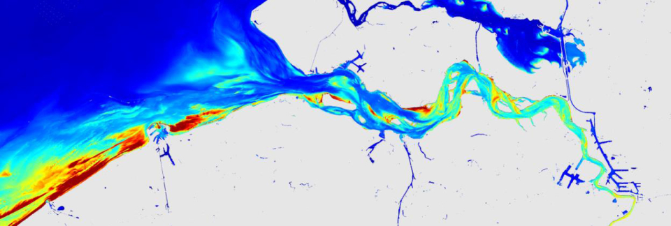
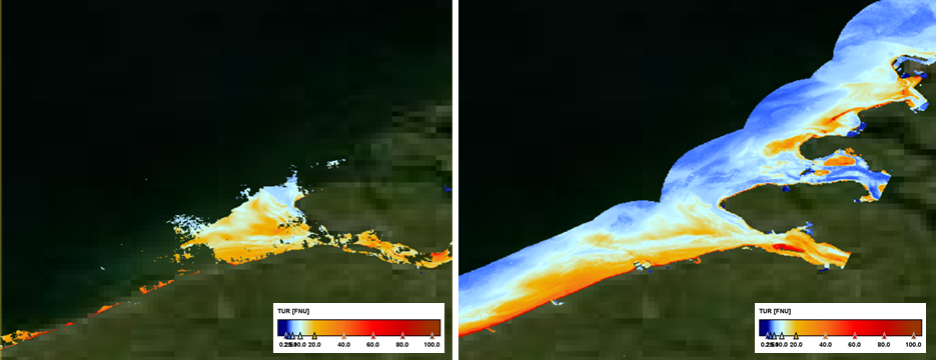
- Quantification of spatial multi-scale effects and temporal dynamics describing observation differences when using different sensors (e.g. Sentinel-2 vs Sentinel-3) in dynamic coastal waters.
- The synergy between Sentinel-2 and Sentinel-3 data has been exploited to generate high spatial and temporal resolution products. The Sentinel-3 and Sentinel-2 data are ingested into the Multi-Scale DINEOF procedure providing a reconstructed dataset with a spatial resolution similar to the Sentinel-2 data, even in dates when only Sentinel-3 data were used. The approach was used to generate high resolution CHL products for the 1st nautical mile zone in the Belgian Coastal Zone, relevant for WFD eutrophication monitoring.
Societal (including environmental) relevance
Foam detection, Aquaculture support, Eutrophication monitoring for European Directives (MSFD, WFD), support of ocean colour community through CMEMS.
Products and services
- Eutrophication monitoring service for OSPAR using 23 years of daily gap-filled S3plus chlorophyll-a (CHL) and suspended particulate matter products (SPM) for the North Sea.
- CMEMS high resolution service which provides high resolution (SPM, CHL and Rrs) products based on Sentinel-2 MSI data for all European Seas (i.e. Arctic Sea, Baltic Sea, North Western Shelf, Iberian Coast, Mediterranean Sea, Black Sea) (https://marine.copernicus.eu).
- Water quality monitoring service for the aquaculture sector providing gap-filled S3plus CHL and SPM products to ingest into a mussels’ growth model
- Phaeocystis Globosa foam detection service for the Belgian Coast Guard to alert for dangerous foam accumulation on the Belgian beaches.
Potential users
CMEMS, OSPAR, policy makers, modellers, Aquaculture sector, researchers/students.
Outreach
Eutrophication monitoring of Belgian coastal waters with MULTI-SYNC
Eutrofiëring opvolgen in de Belgische kustwateren met MULTI-SYNC
Surveiller l’eutrophisation des eaux côtières belges grâce à MULTI-SYNC
| Project leader(s): | IRSNB/KBIN - Royal Belgian Institute of Natural Sciences | |||
| Belgian partner(s) |
|
|||
| Location: |
Country:
Region:
|
|||
| Related presentations: | ||||
| Related publications: | ||||
| Website: | https://odnature.naturalsciences.be/multi-sync/en/ | |||