Published on 8 December 2022
When the sun blinds the images
Algorithms for estimating the concentrations of algal and non-algal particles in aquatic environments based on aerial or satellite data are relatively well developed. However, they sometimes show very significant errors due to the fact that images are taken from different positions compared to the sun. Indeed, when two optical sensors measure upward light beam from a single target, they will measure different radiance values depending of their position around the target. This is due to the fact that sun light is directional and when interacting with matter it is not scattered homogeneously in all directions. For instance, satellite radiometers targeting water can observe, in addition to light coming from the water and light scattered from the atmosphere, the light resulting from the direct reflection of the solar beam to the water surface which is called sunglint.
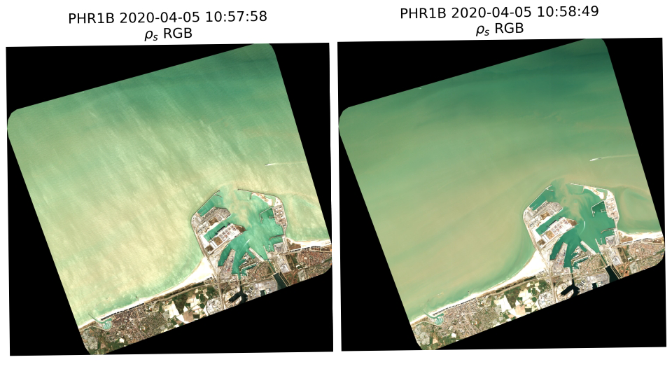 Two stereo Pleiades (RGB) images, one contaminated with glint (left) and one not-glinted (right). Images were acquired on top of Zeebrugge harbour on 5 April 2020.
Hence, to be able to compare measurements made from different directions it is important to know the distribution of light for different azimuthal and zenithal positions compared to the sun position. The function describing this bi-angular distribution is called BRDF for Bidirectional Reflectance Distribution Function. BRDF depends of particulates and molecules interacting with light hence it is different in each medium.
The AQUALOOKS project team, led by the REMSEM (Remote Sensing and Ecosystem Modelling) cell of the Royal Institute of Natural Sciences, used light measurements from different directions to obtain the bi-angular light distribution. Measurements were performed in water, at the water surface and on top of the atmosphere thanks to satellites allowing a multi-views acquisitions (CHRIS-PROBA and Pléiades).
In water, at the water surface
For in water multi-look measurements, a floating structure allowing multi-angular radiometric measurements has been designed. Together with radiometric measurements, inherent optical properties (IOPs) were also recorded which further characterize the scattering and absorption properties of the water. Coupling datasets of both radiometry and IOPs allows for development and testing of existing and future ocean color algorithms.
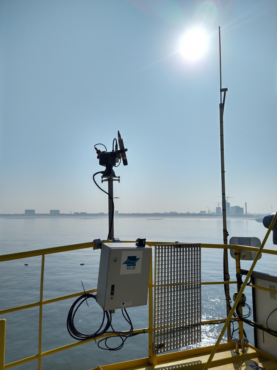
PANTHYR installation performing measurements on the RT1 platform near the port of Ostend
Multi-looks above water measurements were performed with the PANTHYR-2 system, an autonomous system for measurements of hyperspectral above water reflectance. It is equipped with two radiometers to measure downwelling and upwelling radiance from the water and downwelling from the sky. While the radiance measurements are directional, the downwelling irradiance integrates all the radiance from a half-sphere. The PANTHYR system was originally designed for the validation of satellite data. However, the new version of the PANTHYR (PANTHYR-2) has the advantage of being pointable in azimuth and in zenith. This pointability allows for additional experiments. For instance, PANTHYR-2 has been used to analyze the bi-angular (azimuth and zenith) distribution of light at the interface between water and atmosphere. PANTHYR-2 was operational on RT1 platform 500m from the Ostend harbour from December 2019 to August 2020 and from September 2021 to now.
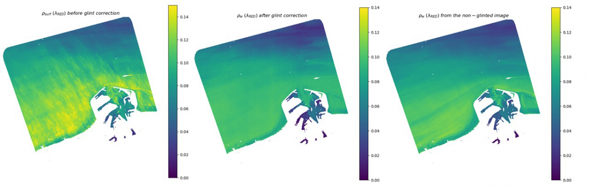
Example of the results of the sunglint correction algorithm on the Zeebruge harbour images. Left: surface reflectance in the red spectral band from the glinted image after atmospheric correction. Middle: estimation of water reflectance in the red spectral band after application of atmospheric correction algorithm. Right: water reflectance in the red spectral band obtained after atmospheric correction of the non-glinted image.
...and well above the water
From dual-look stereo Pléiades satellite images, direct solar reflection (sunglint reflectance) was computed and a new method to correct sunglint was developed. This method, contrary to existing glint correction algorithms, is adapted to turbid regions and for sensors with no SWIR band (spectral band between 1000 and 2500 nm).
Glint corrected images from Pléiades glinted images were compared with colocalized images taken at the same moment with a different looking geometry. And the results are rather encouraging since glint could be removed and averaged overestimation reduced to less than 30 % in visible bands. In addition, main water reflectance patterns were retrieved. This algorithm can be adapted to other high-resolution sensors such as Sentinel-2 frequently impacted by sunglint.