Published on 6 April 2023

Location of the two study catchments ‘Demer’ and ‘Ourthe’ within the Scheldt and Meuse river basin in Belgium
Soil moisture, a key variable
Normally, researchers use computer models tho simulate river flow. Getting an accurate simulation is a challenge because there are many factors that can cause errors. For example, the way the model is built, the data it uses, and the starting conditions all play a role.
One key piece of information for hydrological models is soil moisture because it directly affects the prediction of streamflow. The better the estimation of soil moisture, the better the overall prediction will be.
Satellite data assimilation
To make these models more accurate, information about soil moisture and vegetation in the river basin that they obtain from radar satellite imagery is injected into the model.
Radar instruments send electromagnetic waves (such as radio waves) off to the surface of the earth. Part of the signal (what we call the backscatter) is reflected back to the satellite. The amount of backscatter received by the radar provides information about the characteristics of the surface, such as vegetation cover and water content.
This method of improving models is known as data assimilation. Two different computer models were compared: SCHEME, a hydrological model developed at the Royal Meteorological Institute of Belgium, and NASA’s Land Surface Model Noah-MP.
The EODAHR team used two types of backscatter data (C-SAR from the Sentinel-1 satellite and ASCAt from the METOP satellite). The differences between satellite observations and model predictions were used to update the soil moisture and vegetation state. This in turn improves the predictions of river flow. The researchers found that their data assimilation worked better in the Ourthe catchment, where there is a stronger relationship between the amount of moisture in the soil and how much rain water flows into the river.
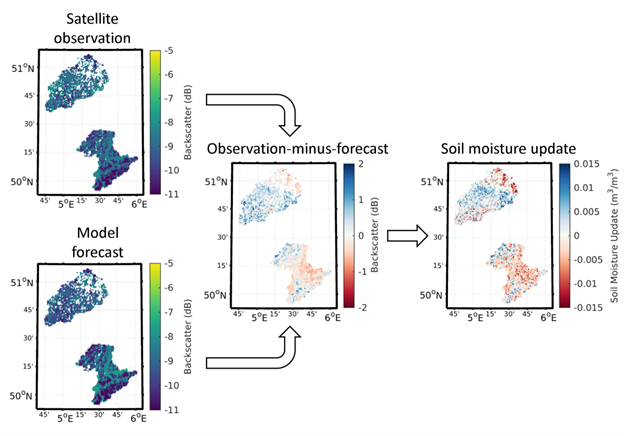
Illustration of spatial soil moisture updates on 4 September 2017
In conclusion, this project helped the team understand how and where they can use information from satellites to make more accurate predictions about river flow. This is important for people who make flood forecasts to keep communities safe.
The EODAHR team
|
|

|
||
|
Sara Modanesi |
Michel Bechtold |
Alberto Carrassi |
Emmanuel Roulin |