The basic definition of a flood is: an overflowing of water onto land that is normally dry. The consequences of floods are sometimes very severe and, during the 20th century, floods were the deadliest and most destructive natural disaster in the United States.
The North American continent is mainly affected by five types of floods:
1. Heavy rains can be responsible of "regional floods" as in the Mexican states Tabasco and Chiapas.
At the end of October 2007, heavy rain related to a storm present in the Gulf of Mexico fell continuously over the southern Gulf Coast during an entire week. The result was very severe floods which covered some 70% of the state of Tabasco, including the capital Villahermosa.
At least 20,000 people were forced to seek emergency shelters and 1 million people's homes were under water. The floods caused profound devastation to agriculture, which is the principal source of income in the state. Indeed, the heavy rains occurred during the cocoa harvest (the state of Tabasco is the largest producer of cocoa in the country). All the 2007 harvest were lost.
The constant extraction of petroleum and gas, the construction of dams in the zone and land erosion have all contributed to making this region more prone to flooding. Deforestation has also allowed silt to deposit in rivers, thus reducing their capacity and making floods more likely.
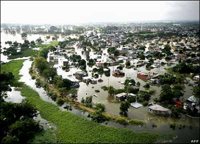
Some 70% of the Tabasco low-lying state was thought to be under water, including the capital Villahermosa - Source
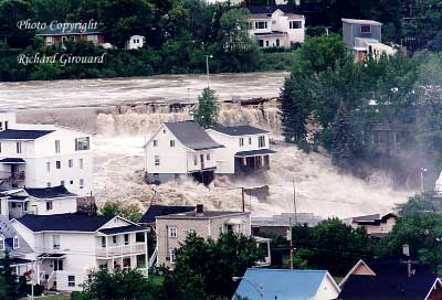
The Saguenay flash flood in Quebec, 19th July 1996 - Photo by Richard Girouard
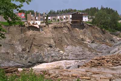
A slope of the river after the Saguenay flash flood in Quebec in 1996 - Source
2. Another kind of flood is the "flash flood" which is defined as a local flood of great volume and short duration generally resulting from heavy rainfall in the immediate vicinity.
A well known example of this kind of event in North America is the Saguenay Flood, a series of flash floods that hit the Saguenay-Lac-Saint-Jean region of Quebec, Canada on July 19 and 20, 1996. It was the biggest overland flood in 20th century Canadian history.
Problems started after two weeks of constant rain which severely saturated soils, rivers and reservoirs. The Saguenay region is a geological graben, which increased the effect of the sudden massive rains of July 19. In the span of a few hours, 270 mm fell on the region, the equivalent to the amount of rain usually received in a month.
The storm produced the largest deluge ever seen in Canada this century. The wave of water, rocks, trees and mud of 2.5 meters high ran through parts of Chicoutimi and La Baie, completely leveling an entire neighborhood. The enquiries have shown that the rain was the main cause of this disaster but also that the network of dikes and dams protecting the city was poorly maintained. The toll of the disaster rose to ten dead, 488 homes destroyed, 1,230 homes damaged and 16,000 people evacuated from the entire area.
3. Heavy rain can also be the main cause of "dam and levee-failure floods" like it happened on Hawaii Island in 2006.
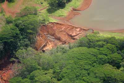 The Ka Loko Reservoir is a reservoir created by an earthen dam, on the island of Kauai, Hawaii. Waters flow from Ka Loko Reservoir down to another lake, then to the Waiakalua river and down to the Pacific Ocean. After unusually heavy rain, the Ka Lokos dam bursted on March 14, 2006. The flood from the dam went towards the town of Kilauea with a wall of water reported to be between 6 to 20 m high and 60 m wide. The flood killed 7 people and destroyed several homes.
The climatic conditions are the main cause of this disaster but several human factors have led to the dam failure. Indeed, the dam was not properly maintained nor inspected, and the owner of the dam performed important works near the dam without permits. These unpermitted operations were known by the administration but the works have not been stopped.
A close-up aerial photo of the Ka Loko Dam breach - Photo by Christopher P. Becker
4. Each year, the Southern part of the continent is affected by hurricanes which are sometimes responsible of "storm-hurricane floods". A well known example of this kind of phenomenon is the flood that covered the city of New Orleans during Katrina.
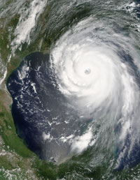 Hurricane Katrina formed over the Bahamas on August 23, 2005, and crossed southern Florida as a moderate category 1 hurricane, causing some deaths and flooding before strengthening rapidly in the Gulf of Mexico. The storm made its second landfall as a category 3 storm on the morning of August 29 in south-east Louisiana. The most severe loss of life and property damage occurred in New Orleans, which flooded after the levee system catastrophically failed. 80% of the city became flooded and at least 1,836 people lost their lives.
Satellite view of the Hurricane Katrina (August 28 2005) - Source
5. It is also possible that a flood is not directly related to precipitation. This is the case in northern regions where the ice melting at the end of the winter sometimes causes "ice-jam floods".
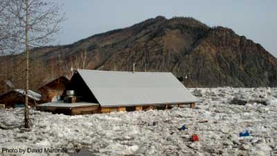 Very recently, the village of Eagle in Alaska was completely devastated by floods. This village sits on the shores of the Yukon River in northern Alaska in a very rugged region. The river winds out of the massive Ogilvie Mountain range in the Yukon Territory of Canada and across Alaska before dumping into the Bering Sea. This past winter, the snow pack in the region close to the Eagle village, northeastern Alaska, was higher than usual and the ice on the Yukon River was about 60 cm thicker than previous years. In May, an unseasonably warm weather caused rapid snow melting and ice movement on the Yukon creating the perfect flood. Residents were awakened by the rising of the water level which was so fast that they had to run away and leave everything.
The Yukon reached approximately 6 m above its previous highest flood mark and the National Weather Service called the flooding "one of the worst floods of record".
All these examples mentioned above are the results of extreme climatic conditions but human impact often aggravates the consequences of the flood.
Sources
Hurricane Katrina - NOAA
Significant Floods in the United States During the 20th Century - USGS Measures a Century of Floods
The Great USA Flood of 1993 NOAA National Weather Service
TheTop Ten Weather Stories of 1996 - Environment Canada's World Wide Web Site
Wikipedia Hurricane - Flood - Kaloko Dam - 2007 Tabasco flood - Saguenay_Flood
Yukon River Flood Devastates City of Eagle - Sequim & Port Angeles News Online
This page was written in 2009, as additional information to the poster series "10 years of Imaging the Earth"