A bit of history
In historic times, glaciers grew during a cool period from about 1550 to 1850 known as the Little Ice Age. General retreat of glacier tongues started after 1800, with considerable mean retreat rates in all regions after 1850 lasting throughout the 20th century.
Since the 1990’s, glacier retreat has become increasingly rapid. Melting of glaciers and ice caps contributed 0.77 mm per year to sea level rise between 1991 and 2004. Strongest mass losses per unit area have been observed in Patagonia, Alaska and Northwest USA and Southwest Canada.
Indicators of climate change
Glaciers and ice caps provide among the most visible indications of the effects of climate change. The mass balance at the surface of a glacier (the gain or loss of snow and ice over a hydrological cycle) is determined by the climate. A climate change will affect the magnitude of the accumulation and ablation terms and the length of the mass balance seasons. The glacier will then change its extent towards a size that makes the total mass balance (the mass gain or loss over the entire glacier) zero.

Global glacier mass balance - The solid red line in E denotes the cumulative global glacier mass balance.
Source : IPCC Fourth Assessment Report, Working Group I Report "The Physical Science Basis"
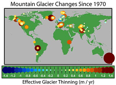
The map below shows the average annual rate of thinning since 1970 for the 173 glaciers that have been measured at least 5 times between 1970 and 2004. Larger changes are plotted as larger circles and towards the back. All survey regions except Scandinavia show a net thinning. This widespread glacier retreat is generally regarded as a sign of post-1970 global warming.

Effective glacier thinning (m/year). Source : Robert A. Rohde

Large-scale regional mean length variations of glacier tongues
Source : IPCC Fourth Assessment Report, Working Group I Report "The Physical Science Basis"
Glaciers in South America
South American glaciers are located in the Andes mountains and in Patagonia. Except for a few cases, they have shown an enhanced retreat trend in recent decades.
Patagonia hold the third largest land-ice area, following Antarctica and Greenland, which is also the world's largest mountain glacier.
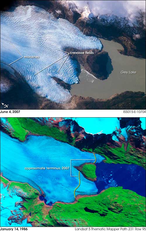
The Northern Patagonian Icefield lost about 3.4% (140 km²) of its area between 1942 and 2001. Thinning rates of up to 30 meter per year have been observed recently in the Southern Patagonian Icefield, with a relevant contribution to sea level rise.
Patagonian glaciers are receding at a faster rate than in any other region in the world.
Impacts of retreating glaciers
Glaciers in South America are critically important as water resource for domestic, agricultural and industrial uses.
The loss of glaciers not only directly causes landslides, flash floods and glacial lake overflow, but also increases annual variation in water flows in rivers.
A great deal of the population surrounding the central and southern Andes reside in arid areas and are dependent on water runoff from glaciers that melt during the warmer summer months. In these areas, a continuation of the current retreat will eventually deplete the glacial ice and substantially reduce or eliminate runoff.
A reduction in runoff will affect the ability to irrigate crops and will reduce summer stream flows necessary to keep dams and reservoirs replenished, threatening hydroelectricity generation.
Andean glaciers are melting so fast that some are expected to disappear within 15-25 years, denying major cities water resources and putting populations and food supplies at risk in Colombia, Peru, Chile, Venezuela, Ecuador, Argentina and Bolivia. Latin Americans living in water-stressed watersheds (less than 1,000 m³/capita per year) in the absence of climate change were estimated to number 22.2 million in 1995. This number is expected to rise up to 79 to 178 million in the 2050’s.
Sources
Cities in peril as Andean glaciers melt - Guardian.co.uk
Global Glacier Changes: facts and figures - UNEP
IPCC Fourth Assessment Report
Wikipedia - Effects of global warming
Wikipedia- Retreat of glaciers since 1850

Grey glacier, Chile, Southern Patagonian Icefield. Source: NASA Earth Observatory
This page was written in 2009, as additional information to the poster series "10 years of Imaging the Earth"