Is the trend towards ever increasing sprawl ebbing?
Urbanisation
Worldwide, urbanisation and urban growth continue to be major demographic trends.
The global proportion of urban population increased from 13% in 1900 to 49% in 2005. By 2030, 60% of the global population is expected to live in cities.
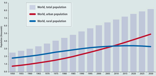
Modern patterns of city growth are increasingly land-intensive. As transportation continues to improve, the tendency is for cities to use up more and more land per person. In both developing and industrialized countries, the average density of cities has been declining quickly: at an annual rate of 1.7% over the last decade in developing countries and 2.2% in industrialized countries.
Petroleum-based fuels are primary drivers for urbanisation.
Urban sprawl in the United States: from suburbs to exurbs
Urban sprawl is the spreading out of a city and its suburbs over more and more rural land. Between 1982 and 1997 America converted over 10 million ha of natural habitats and rural land to developed land.
As of mid-2005, 81% of the population in the U.S. resided in cities and suburbs (up from 70% in 1960). Yet there is a trend of Americans moving away from big urban centres to the fringes of the urban areas in search of more space and more affordable housing. In the 20 largest cities and urbanized areas of the United States, only 41% of the population lives in the city itself, while 59% lives in the surrounding area.
At the edge of the city is the suburb. At the edge of the suburb, as metropolitan areas have expanded out, is the exurb.
Suburbs are residential communities lying immediately outside a city. They began to appear in the 18th century as a preserve of the wealthiest Americans who could afford to commute to the city.
Urban sprawl took off after World War II. Faced with a housing shortage, developers applied the principles of mass production to housing, creating nearly identical houses on moderate-sized lots. The government contributed to suburbanization by subsidizing mortgages for veterans and building highways that made travel between cities and suburbs easier. Suburbs came to epitomise the American dream where everyone could aspire to a better quality of life.
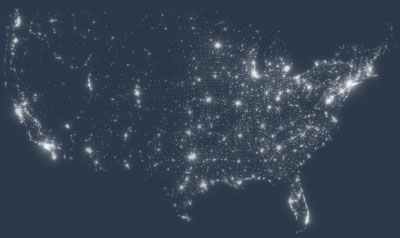
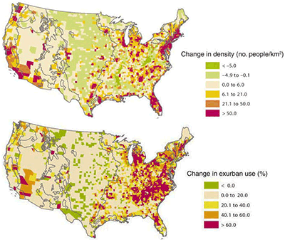
Light pollution (Source) & Maps of change by county in population density and percentage of area exurbanized, between 1950 and 2000
Source: Rural Land-use Trends int he Conterminous US,1950–2000
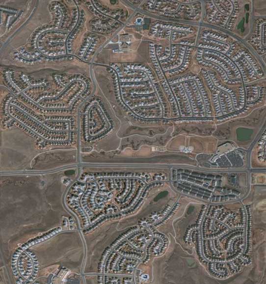
QuickBird Natural Color Image of an Urban Sprawl - Copyright © 2001-2009 Satellite Imaging Corporation
As the suburbs grew, more and more of the middle classes abandoned the cities as the suburbs were cleaner, newer, had better-funded schools, bigger houses, were socially homogeneous, and provided a sense of security. Once the population shifted to the suburbs, employers eventually followed.
The intensive use of the automobile for daily commuting was both a cause and a consequence of urban sprawl. Traffic congestion is an increasing problem in cities and suburbs, and Americans spend more and more of their time commuting to work, school, shopping, and social events. By the late 1990s traffic had become heavy both to and from cities as well as between suburban locations.
Hoping for more space, and better and cheaper housing, people continued to look to the fringes of urban areas. In the 1990s older suburbs were losing population to newer suburbs and to the so-called exurbs, rural areas bordering cities.
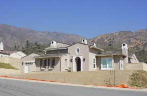
McMansion is a term to describe a particular type of housing that is rapidly constructed using modern labour-saving techniques in a manner reminiscent of food production at McDonald's fast food restaurants. It refers to a house with a larger footprint (> 280 m²) than a median home and which is often located in a new urban development. Often the house is built on a comparatively small lot in homogeneous communities produced by a developer. Although generally large and relatively expensive, McMansions are distinguished from "true" mansions by the fact that they are mass produced and are not architecturally unique.
Source: Wikimedia

The expression "exurb" describes the ring of prosperous communities beyond the suburbs that are not yet fully-fledged suburbs, but no longer wholly rural either.
Exurbs have at least 20% of their workers commuting to jobs in an urbanized area, exhibit low housing density, and have relatively high population growth. Exurban areas grew more than twice as fast as their respective metropolitan areas overall, by 31% in the 1990s alone. The typical exurban tract has 570 ares of land per home, compared to 32 ares per home for an average tract. Residents are on average white, middle-income, homeowners, and commuters.
The future of urban sprawl
For decades, the growth of suburban housing was based on cheap gas. The low price of gas made sprawl economical.
A sharp and sustained rise in gasoline prices could reverse current urbanisation trends by making the private automobile and extensive commuting too expensive. As the price per gallon of gasoline has gone up, housing prices have fallen. Although housing prices are in decline almost everywhere, price declines are generally far more severe in far-flung suburbs that require lengthy commutes than near the centre of densely populated cities. Living in exurban area influences the disposable income: in exurban areas of Minnesota, families were spending almost a third of their income on transportation while urban residents spent 20%. More and more Americans are therefore looking for a place closer to live to work.
The number of miles travelled per person each day rose for the last two decades, as the real cost of driving a car declined. Lately, however, those trends reversed. The total number of vehicle miles travelled in March 2008 was 4.3 % lower than the previous year.
|
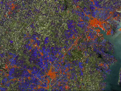
| Monitoring urban sprawl through remote sensing Urban sprawl results in more paved surfaces. Maps of these so-called impervious surfaces derived from satellite images are now used to capture new urban development and replace the more expensive and time-consuming traditional aerial photography to provide urban planners with a better understanding of city growth. By monitoring an area over time, maps can show the progress of residential development. |
The cost of urban sprawl
The term urban sprawl generally has negative connotations due to social (lack of social mix), environmental and even health (physical inactivity) issues that sprawl creates.
Most obvious is the consumption of precious land and the loss of wildlife, but because sprawl supports and heavily depends on automobile use, it is a major contributor to climate change and air pollution. Sprawling communities also use excessive amounts of energy for water and sewer services, distribute natural gas and electricity over long distances, and require municipal services like waste and recycling pick-up over large areas. This causes even more air pollution, further deteriorating human and ecosystem health.
Sources
Ecosystems and Human Well-being: Current State and Trends- Urban Systems - Center for International Earth Science Information Network - Colombia University
Finding Exurbia: America's Fast-Growing Communities at the Metropolitan Fringe - Brookings
New Satellite Maps Provide Planners Improved Urban sprawl insight - NASA GSFC
UNFPA State of the World Population - Peering into the Dawn of an Urban Millennium
Urban Growth in American Cities - USGS
Urbanization of Americca - TheUSAonline
This page was written in 2009, as additional information to the poster series "10 years of Imaging the Earth"