Published on 3 March 2022
As urban areas are the main sources of carbon emissions, recent studies have highlighted the key role played by urban tree vegetation in carbon sequestration. Their contribution to carbon storage is often overlooked in global carbon cycle estimates, not least because they are perceived as negligible in relation to global forest cover.
However, in some densely populated, sparsely forested areas that are expected to expand further in the future, it is essential to quantify, monitor and understand the role of urban trees in storing carbon and combating climate change.
The 3D-CITREES project (Estimating the aboveground biomass of city trees in Ghent, Belgium) attempted to address this challenge by using LIDAR and very high resolution optical data to map the above-ground biomass of trees in the city of Ghent.

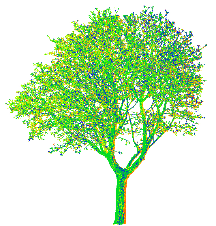
Co-registration of different scans in one location. Each colour is coming from a single scan position.
Trees: not just green stuff
In the urban landscape, trees and woodlands fulfil many essential functions. In addition to their obvious aesthetic role, they improve the physical and psychological well-being of city dwellers, fulfil a social and sometimes even an economic function and improve the comfort of residents. But the most important benefits of trees are environmental:
- they act as natural air-conditioners by lowering the ambient temperature and promoting better ventilation (thanks to evapotranspiration and the absorption and reflection of part of the sun's radiation);
- they improve and protect soil structure and water quality in the soil;
- they maintain biodiversity in cities;
- they purify the air by producing oxygen, reducing polluting gases and filtering dust and aerosols;
- and, last but not least, they absorb part of the atmospheric CO2 through photosynthesis and thus play a major role in the local and global carbon cycle.
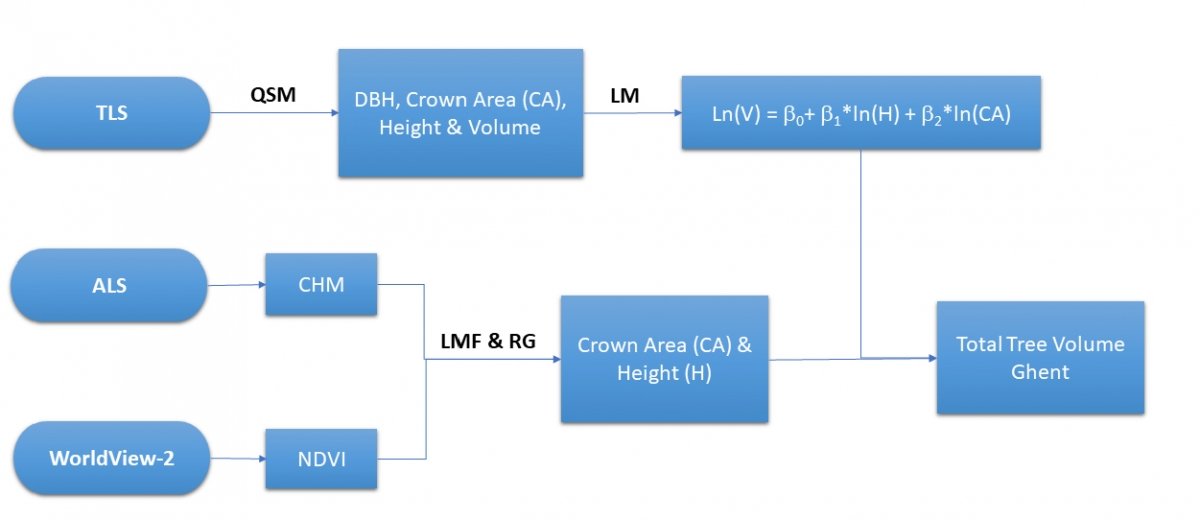
Overview of the different processes used to assess the total tree volume. QSM: Quantitative Structure Model, LM: Linear Regression, NDVI: Normalized Difference Vegetation Index, CHM: Canopy Height Model, LMF: Local Maxima Filtering, RG: Region Growing.
Estimating the contribution of urban trees
Flanders, where forests cover only 10% of the territory, is a perfect example of a region where the role of urban trees in carbon sequestration cannot be ignored.
The 3D-CITREES project team, all from Ghent University, chose their city as a study area to define a carbon estimation method applicable to urban environments. The city has more than 58,000 trees, individually maintained by the administration and distributed along streets, waterways, cemeteries, squares and public parks. But it also includes many private green spaces that are not taken into account in the biomass estimates based only on the inventories carried out by the city services.
The above-ground carbon stored in a tree is estimated to be about 50% of its above-ground biomass (AGB). Traditional methods for estimating aboveground biomass are defined for forest ecosystems and use allometric models, which relate easily measurable tree structural parameters such as Diameter at Breast Height (DBH) to tree height.
However, these models cannot be applied to urban environments. This is because the growing conditions in cities and forests are very different and result in different structures. For example, in open urban areas with more light availability, trees are shorter and have wider crowns than in forests. In addition, trees along streets are frequently pruned to ensure safety and improve visibility at street level.
Alternative methods must therefore be developed to reliably estimate the above-ground biomass of all trees in the city.
 |
 |
Remote sensing to the rescue

The project team took advantage of recent advances in LiDAR technology, as well as the availability of very high resolution imagery, to visualise the structural complexity of forests in unprecedented detail and subsequently also generate aerial biomass maps of the city of Ghent.
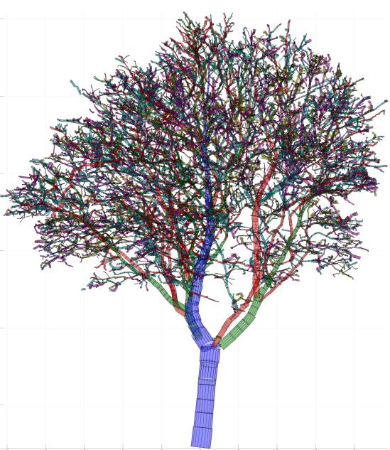
LiDAR is a technology that uses laser pulses to accurately determine the distance of surveyed objects or surfaces from the instrument. A 3D point cloud of the scanned environment is then created. Terrestrial LiDAR systems scan the region of interest from static locations on the ground and provide high resolution data on small spatial scales. They provide a very detailed 3D structure of the trees, from which the AGB and carbon stock can be derived. For this purpose, quantitative structure models (QSM) can be created by fitting cylinders to the point cloud.
The volume of above-ground trees can then be converted to AGB using wood density, determined by the ratio of the dry weight of a wood sample to its green volume. This can be measured on tree samples or estimated from literature data.
To improve high-resolution biomass estimates, data recorded by an airborne LiDAR system can provide estimates of tree height and crown size. In addition, highly detailed, sub-metre resolution optical satellite images, such as those acquired by the commercial Worldview-2 satellite (which provides panchromatic images at 46 cm nadir resolution and multispectral images covering eight bands), allow individual trees to be detected and their crowns mapped from space.
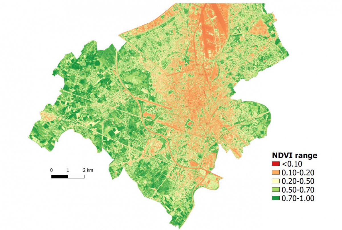
NDVI image of the city of Ghent, obtained via raster calculation with pansharpened (fusion of high-resolution panchromatic image and multispectral information) red and near infrared on the Worldview-2 bands. NDVI values below 0.1 correspond to areas without vegetation (e.g. water bodies), from 0.1 to 0.2 to bare soil, above 0.2 to low and high vegetation. The red and orange zones match with densely populated and busy areas, including the harbour in the upper right corner.
A useful detailed count
The 3D-CITREES project located all urban trees in the city of Ghent (with the exception of the sparsely forested harbour area not included in the study area) and mapped the aboveground biomass. In total, 262,863 trees over 4 meters large were detected over an area of 120 km². The total above-ground carbon stock was estimated at 312,710 tonnes of carbon, which corresponds to an average density of 26.06 tC/ha (tonnes of carbon per hectare).
The results generated by this project are crucial for both urban planning and the city's carbon reduction policies.
In addition, the project has enabled the development of a reliable method for determining aboveground biomass and carbon sequestration in an urban environment. This method can be used in the future for other urban areas and at any scale, be it for a hundred trees or for an entire city.
More information
Gentse bomen voor het eerst geteld (UGent)
Jasper telde alle bomen in Gent. Het zijn er 263.863 (Radio 2)