Published on 12 May 2023
The objective of the STEREO III project ECTIC was to evaluate ICEYE imagery, especially targeting their ability to provide information for two main applications:
- the height change detection for lava lake monitoring using time series, with a focus on the Nyiragongo volcano in eastern Congo in the Democratic Republic of Congo (DRC);
- change detection by measuring spectral coherence, of environmental changes such as deforestation in the Goma region and changes of anthropogenic origin such as the monitoring of ships on Lake Kivu.
ICEYE is a Finnish low Earth orbit (LEO) constellation of more than 20 small Synthetic Aperture radar (SAR) satellites, working in X-band (~3 cm wavelength) and designed for observing Earth at fine resolution.
An ICEYE data quota was granted by ESA for the realization of the project. Seven images have been studied in the framework of the first application: five high resolution images (1 meter resolution, "Spotlight" acquisition mode) of the Nyiragongo crater and two images at a resolution of 3 meters ( "Stripmap" acquisition mode) of the Goma area, taken at a one year interval for the analysis of the spectral coherence.
Indicator of volcanic activity
The first application, the detection of lava lake height variations, is done by measuring the observed changes of shadows cast by vertical structures of the crater, by handling amplitude images allowing to detect height changes.
Changes in lava lake level are indicators of the volcanic activity, used in conjunction with other monitored indicators. Their measurements are used as a proxy for detecting pressure changes in the volcano magmatic system. During high activity periods, the lava lake is overflowing, covering the subhorizontal crater floor with a new lava layer and hence shortening the crater depth after solidification.
The project team, composed of members of the Centre spatial de Liège and the European Center for Geodynamics and Seismology (Luxembourg), tested the detection of height changes on the Nyiragongo volcano's lava lake in the Virunga volcanic province of the DRC.
Measurements of the lava lake level are performed by evaluating the length of the SAR shadow cast by the sub-vertical rim surrounding the crater. The lava lake level is then computed using a simple trigonometric calculation based on that shadow length. This technique had already been successfully used based on images from CosmoSkyMed and Radarsat satellites and is now used for routine monitoring using Sentinel-1.
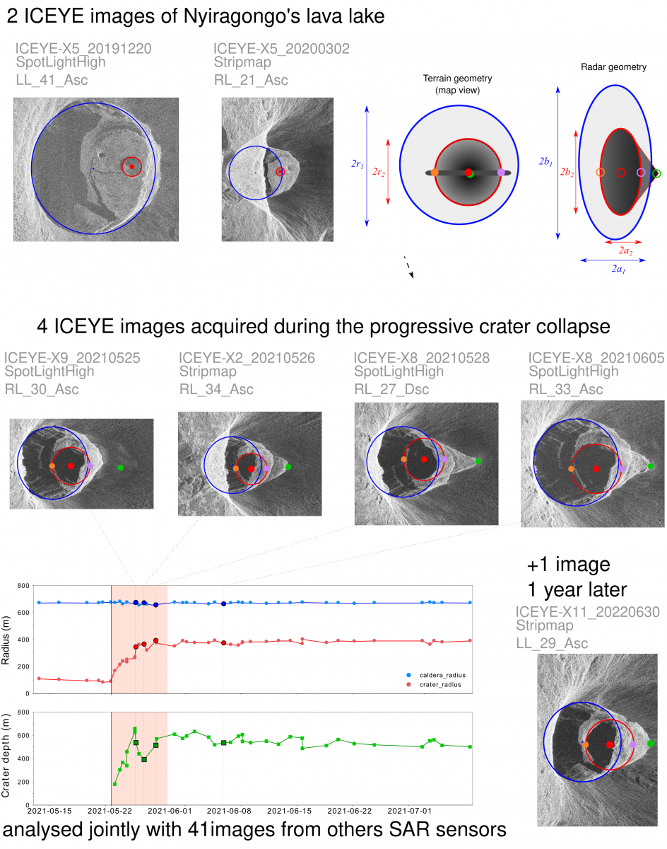
Nyiragongo crater and lava lake – Results from the analysis of 7 ICEYE images acquired before, during and after the eruption of Nyiragongo volcano (DRCongo) of May 2021, jointly analysed with 41 images from other SAR sensors.
The team was able to demonstrate that ICEYE images provide similar measurements of crater depth and diameter to those obtained with other sensors. All the results obtained with ICEYE measurements taken during pre-eruptive, eruption, and post-eruptive phases (acquisitions between December 2019 and May 2021) confirmed what was already observed with the other types of available SAR satellite data (more than 40 ALOS2, CSK, Capella, RCM, SAOCOM, Sentinel-1 and TerraSAR-X images). However, the sub-metric resolution, offered by the new ICEYE Spotlight data, now allows to image geomorphological features with a better resolution. The ICEYE measurements were then integrated to the existing time series obtained from other sensors.
Tracking ships and deforestation
The second application was to apply interferometric processing developed by the project partners (and already adapted to the processing of images from many sensors) to pairs of images taken in a short time interval. The team first tested the processing on images freely available from the ICEYE website. The processing of a pair of high-resolution (Spotlight) acquisitions of the Rotterdam harbour, providing a ground sampling of 2x2 meters (see below), demonstrated that the ICEYE data were well handled throughout the project by the image processor tailored by the team.
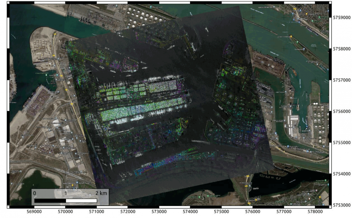
HSV colour composition of interferogram (H), coherence (S) and amplitude image (V) of Rotterdam harbour ICEYE InSAR data set.
The team then generated interferometric products from a set of 4 images acquired over the Amazon rainforest in Brazil, which allowed to highlight deforested areas (see image below).
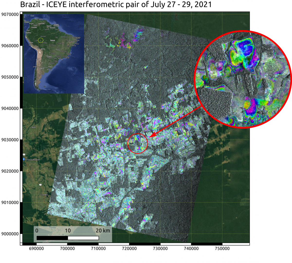
Brazil, Amazon Forest: HSV Color composition of geoprojected coherence, interferogram and amplitude of ICEYE pair of 20210727 – 20210729 showing brightness on deforested areas and coloured fringes where coherence is sufficiently preserved. Hue: interferogram; Saturation: coherence channel multiplied by the inverse of the amplitude; Value: inverse of the amplitude.
Finally, the results for vessel detection with the data granted by ESA (acquired in March 2020 and May 2021) were less convincing. As shown in the figure below, the noise present on some images makes the detection of ships on Lake Kivu very complicated.
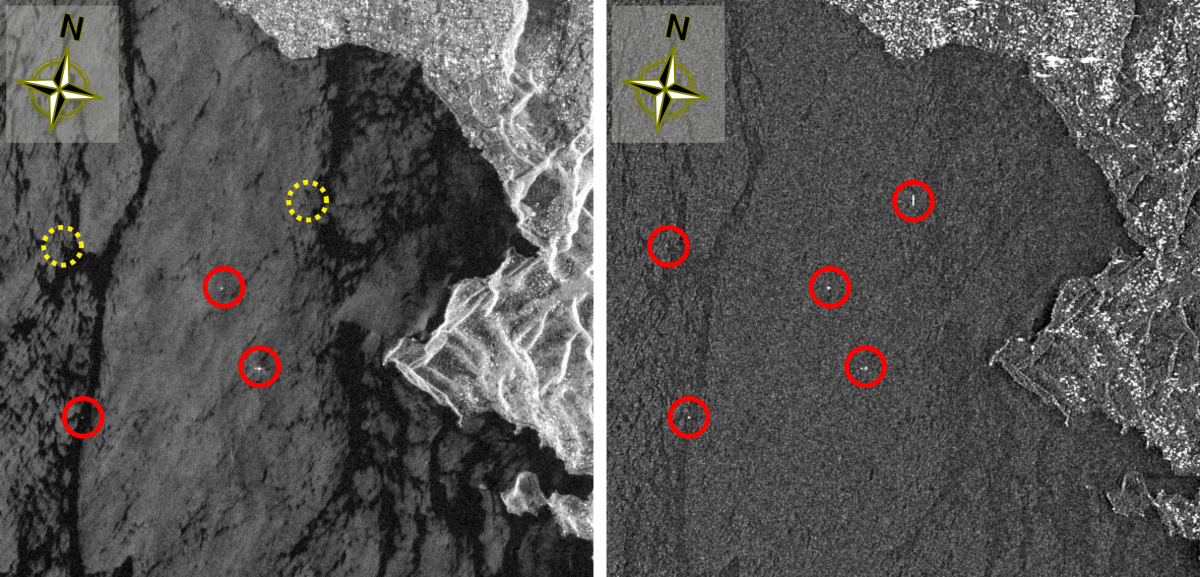
ICEYE image of March 2, 2020. Left: Spectral coherence channel using a split scheme of 21 sub-bands of 30MHz bandwidth each, showing detected targets within red circles; Right: Amplitude image with red circles showing the corresponding target locations. Yellow dotted circles locate vessels that are faintly visible within amplitude image while clearly detected within spectral coherence channel.
The ECTIC project has demonstrated that ICEYE imagery offers significant advantages such as high resolution and different observation geometries. Their use has proved effective in measuring height variations in lava lakes and in highlighting deforested areas. For ship tracking, only comparisons between images acquired in the same viewing geometry have revealed changes. It is therefore important to create time series of images acquired in the same viewing geometry when monitoring over time.
More information
STEREO project ECTIC (Environmental change tracking using ICEYE constellation)
For more information on the CSL InSAR Suite you can contact the project authors, Anne Orban and Dominique Derauw.