Published on 17 July 2026
Climate projections predict that all continents, including Europe, will experience more frequent and more severe summer heatwaves in the coming decades. We are only at the beginning of the summer of 2026, yet Western Europe is already experiencing a record-breaking heatwave, both in terms of temperature and duration.
This highlights the urgent need to better understand the factors that influence our climate. In this context, understanding evaporation processes is crucial. Evaporation influences global climate patterns, drives droughts and floods, and determines how much water remains available for nature, agriculture, and water resource management.
Despite its importance, evaporation remains highly uncertain because it cannot be measured directly from satellite sensors. This is where GLEAM comes in: an advanced model that combines satellite observations and meteorological data to accurately estimate evaporation worldwide.
A new daily data set of evaporation and soil moisture with 1 km resolution
How much water evaporates from the land each day? How dry are soils beneath crops and forests? And how do these processes evolve during droughts and heatwaves?
These questions are central to understanding climate change, ecosystem functioning, agricultural productivity, and water availability. Yet monitoring evaporation (E) and root-zone soil moisture (SM) at high spatial detail across large regions has long remained a scientific and technical challenge.
The HERMES project addressed this gap by developing a new daily dataset of evaporation and root zone soil moisture at 1 km resolution across Europe and Africa. By combining advanced Earth Observation data with hybrid modelling techniques, HERMES delivers one of the most detailed and physically consistent continental-scale datasets produced to date.
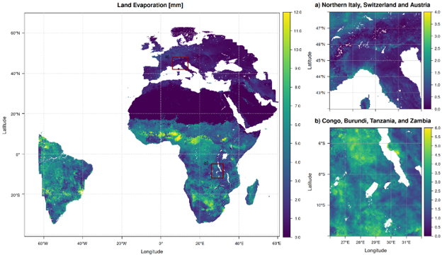
Figure 1: Daily evaporation over land (in mm) on 1 January 2018, calculated for the entire observation area of the Meteosat satellite.
The GLEAM 4 model
At the core of the project lies the Global Land Evaporation Amsterdam Model version 4 (GLEAM4), an advanced modelling framework that combines physical process representations with artificial intelligence. Satellite observations from Meteosat, MODIS, Sentinel-1, and other missions were Integrated with meteorological reanalysis data to generate a comprehensive high-resolution forcing dataset.
Machine learning was used to estimate vegetation stress from hundreds of ground-based eddy covariance flux tower and sap flow measurements, enabling the model to learn from real ecosystem behaviour while preserving physical consistency.


Picture 2: Schematic of GLEAM4 and the list of input variables
Impact of irrigation on evaporation
The project also investigated how irrigation influences evaporation. A new irrigation module was developed by combining satellite-based crop phenology, global irrigation maps and Sentinel-1 data. This enabled the model to better capture agricultural water use without relying on unrealistic assumptions about maximum evaporation rates. Validation over the Iberian Peninsula showed performance improvements at irrigated sites.
Beyond dataset production, the project investigated the drivers of evaporation during extreme events. Using explainable artificial intelligence techniques, the team quantified how radiation, vegetation state, atmospheric demand and soil moisture interact during compound drought–heatwave events, such as the European drought of 2018.
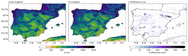
Figure 3. Average annual evaporation E (mm/year) for the period 2018–2022: (a) simulation without irrigation and incorporating soil moisture data, (b) simulation using the new irrigation module, and (c) the difference between the two.
A unique data visualisation system
To make the results accessible, HERMES adopted the Lexcube datacube platform (https://gleam.lexcube.org/), allowing users to interactively explore evaporation and soil moisture in a 3D space–time environment and download customised data subsets.
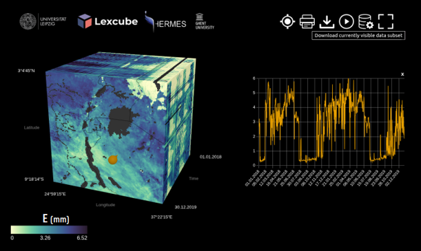
Figure 4. An example of the interactive Lexcube platform (https://gleam.lexcube.org/), which allows users to explore evaporation and soil moisture and to compile bespoke datasets.
HERMES provides researchers and water managers with a powerful new tool for better monitoring the water cycle on a continental scale. By combining physical models, artificial intelligence and satellite observations, the project contributes to improved drought monitoring, more efficient water management in agriculture and greater resilience to the impacts of climate change.

Project partners
UGent: Diego Miralles - Akash KOPPA - Oscar BAEZ-VILLANUEVA - Fangzheng RUAN - Olivier BONTE - Joppe MASSANT - Baris OZTAS
University of Leipzig (GER): Miguel MAHECHA - Maximilian SÖCHTING
University ofValencia (SPA): Gustau CAMPS-VALLS - Alvaro MORENO-MARTINEZ