Published on 5 May 2022
Nowadays, coastal and inland water monitoring routinely uses satellite data but is mostly limited to radiometric measurements acquired from multispectral sensors (which record in a small number of spectral bands). The main parameters derived are the concentration in particulate suspended matter and in chlorophyll-a.
These parameters are very useful for monitoring eutrophication and sediment transport. However, users, including water management agencies, wish to have more detailed information, such as the origin of sediments or the presence of certain (e.g. harmful) phytoplankton species. Users working in very complex waters would also like to have access to more accurate chlorophyll-a products. Indeed, in some very turbid or absorbing waters, obtaining a good estimation of chlorophyll-a concentration is challenging, with most multispectral algorithms failing.
Hyperspectral to the rescue
To address these user demands and to prepare the new generation of hyperspectral sensors (e.g. the sensor for NASA's PACE mission, scheduled for launch this year), the STEREO III project HYPERMAQ explored new applications of hyperspectral radiometry in inland and coastal waters.
|
Hyperspectral sensors are designed to record information in a multitude (often more than 200) of very narrow and often contiguous spectral bands in the visible, near infrared and mid-infrared parts of the electromagnetic spectrum. Hyperspectral data therefore provide more detailed information (a finer spectral signature) about the spectral properties of a scene and allow more precise identification and discrimination of objects than broadband sensors. (See Understanding Remote Sensing) |
A processing chain, dedicated to turbid coastal water applications, was developed to process images from the hyperspectral CHRIS-PROBA sensor and a database was compiled of 96 images acquired over the HYPERMAQ study sites.

PANTHYR prototype installed on the RT1 platform near Ostend harbour
To validate the results obtained by the hyperspectral and multispectral satellite sensors, an autonomous hyperspectral radiometer system was developed. Two PANTHYR prototypes were installed on offshore platforms.
Tracking microalgae
In addition to the validation of satellite data, these instruments have proved to be very useful for ecosystem monitoring. In Belgian coastal waters, it was possible to monitor the proliferation of Phaeocystis globosa, a nuisance phytoplankton species that can cause very large blooms due to excess nitrate in the water. The dense, smelly foam that accumulate in the water and on beaches are a disturbance to fishermen, tourists and residents and interfere with trophic interactions in the marine ecosystem. Thanks to hyperspectral data, it was possible to monitor this species at an unprecedented temporal resolution (hours).
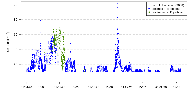
Time-series of chlorophyll-a concentration and P. globosa dominance (color of the dots) calculated from PANTHYR reflectance at RT1 platform in spring 2020. RT1 platform is located 500 m of Ostend harbor.
From field data to future satellite sensors
Numerous in situ measurement campaigns in inland waters and lagoons, estuaries and coastal waters in Europe (Belgian coastal waters and Spuikom and the Verdon and Pauillac sites in the Gironde estuary in France), South America (Rio de la Plata and Chascomus lake in Argentina) and Asia (Chongxi and Baozhen sites in the Yangtze estuary in China) were also performed to acquire data for the development and validation of algorithms.
.
|
|


During these campaigns, optical properties (scattering, absorption, turbidity, water reflectance), suspended particulate matter, pigment concentrations, phytoplankton species composition and sediment composition were measured.
In addition to algorithm development and validation, the HYPERMAQ dataset also allows to better understand the radiometric signature and ecology of certian poorly known and complex environments such as the Spuikom lagoon near Ostend in Belgium.

Quasi-True-Color Red-Green-Blue (RGB) image from Landsat 8 (left) and pixels flagged as floating vegetation from a subset of the Landsat 8 image (middle) and from the same day MODIS Aqua image (right).
After validation, certian algorithms could be applied to satellite data improving water monitoring with a large spatial coverage and frequent revisits.

Chlorophyll-a concentration calculated from a hyperspectral algorithm on CHRIS-PROBA image in the Rio de la Plata. It was demonstrated that for very turbid waters, hyperspectral data allow to improve chlorophyll-a concentration retrieval.
For instance, floating vegetation could be monitored in the very turbid waters of Rio de la Plata in Argentina using multispectral satellite sensors. Moreover, thanks to a hyperspectral algorithm, retrieval of chlorophyll-a concentration was significantly improved in the same river. The analysis of in situ measurements also allowed to make recommendations for future hyperspectral satellite sensors.
 HYPERMAQ (Hyperspectral and multi-mission high resolution optical remote sensing of aquatic environments) project