Published on 30 January 2025
Improving climate monitoring by advancing our understanding of active microwave remote sensing responses to rapid sub-daily land-atmosphere interactions: this is the purpose of the WAVETRAX project. The project will investigate the dynamic interactions of microwaves with Essential Climate Variables (ECVs) in order to address gaps in satellite data interpretation, thereby enhancing the accuracy of climate monitoring. The first essential step is to improve understanding on the ground of microwave responses to sub-daily processes. The project team has therefore installed its own radar antennas at 3 sites to begin collecting data.
Sub-daily processes monitoring
Satellite data provides valuable information about the Earth system and plays a key role in monitoring our climate. However, current satellite missions are limited in their ability to capture detailed, short-term Earth system processes, such as moisture redistribution within the soil-plant-atmosphere continuum driven by plant transpiration, or rain-on-snow events that alter the snow micro-structure and stratigraphy.
Future remote sensing satellite missions can address this critical observation gap by focusing on monitoring sub-daily processes. In particular, active microwave remote sensing observations are highly sensitive to variations in soil moisture, vegetation water content and snow properties, making them well-suited to observing rapid dynamics in the hydrosphere, biosphere and cryosphere.
But first, in order to demonstrate how new active microwave satellite mission concepts could fill this observation gap, improved ground-based understanding of the microwave responses to sub-daily processes is essential.
Three sites and six sensors
The STEREO-IV project WAVETRAX aims to enhance our knowledge of radar scattering signals, and their relationship with sub-daily land processes, through tower radar experiments. In total, three sites will be instrumented, each with two newly developed radar sensors:
- the Fermes Universitaires de Louvain (FERM) site near Louvain-La-Neuve, Belgium, will be equipped with one C-band (5.4 GHz) and one L-band (1.4 GHz) radar;
- the Brundage site in the Idaho Rocky Mountains, USA, will carry two C-band radars;
- the Weissfluhjoch site near Davos, Switzerland, one C-band and one Ku-band (13.5 and 17.3 GHz).
Simultaneously with radar backscatter measurements at the sub-hourly time interval, the team will collect dense time series measurements of various soil, vegetation and snow properties.
 |
|||
|---|---|---|---|
| Radar Band | Frequency | Wavelength | Applications and Use Cases |
|
Ka |
27–40 GHz | 1.1–0.8 cm | Rarely used |
| K | 18–27 GHz | 1.7–1.1 cm | Rarely used |
| Ku | 12-18 GHz | 2.5 - 1.67 cm | Ocean surface winds, sea ice, ice sheets, snow properties; altimetry |
| X | 8 – 12 GHz | 3.8 – 2.5 cm | Urban monitoring, ice and snow, weather monitoring, little penetration into vegetation cover |
| C | 4 – 8 GHz | 7.5 – 3.8 cm | Land use, agricultural monitoring, deforestation, ice, ocean, and maritime navigation |
| S | 2 – 4 GHz | 15 – 7.5 cm | Biomass, forestry management, soil moisture, geology, and hydrology |
| L | 1 – 2 GHz | 30 – 15 cm | Soil moisture, glaciers, geophysical monitoring; biomass and vegetation mapping; inSAR |
| P | 0.3 – 1 GHz | 100 – 30 cm | Deepest penetration capabilities, landslides, erosion, archaeology, and wetlands |
The electromagnetic spectrum with SAR bands highlighted. The table notes SAR bands with their associated frequency and wavelength along with typical applications for that band. Source: https://www.earthdata.nasa.gov/learn/earth-observation-data-basics/sar
Research continuity for extended analysis
This figure below presents a vertical profile of radar backscatter intensity (HH and HV polarization) over time, measured using a C-band radar sensor, along with in-situ observations of snow depth (SD) and snow water equivalent (SWE) at a test site in the Idaho Rocky Mountains, USA. Conducted as part of the STEREO III project C-SNOW, these data provide key insights into the contributing scattering sources within the snowpack and soil surface, and how these contributions change after melt-freeze processes, or the formation of ice layers.

Daily tower radar data (dB) at the Bogus Basin study site, Idaho, USA, for the winter seasons of 2022–2023 and 2023–2024. The two upper panels show how the radar scattering within the snow volume and soil changes over time, respectively in HH and HV polarization. The vertical axis presents the distance (m) from the radar, the horizontal axis the time, and the colour indicates scattering intensity (dB). The lower plot shows the time-series of in-situ measured snow depth, SD (cm) and Snow Water Equivalent, SWE (cm) for the same period.
Such information allows to improve the design of satellite retrieval algorithms for estimating key snow properties like SD and SWE, which serve a wide range of applications, including water resources management and hydropower operations.
During the follow-up project WAVETRAX, this scatter signature analysis will be greatly extended, using new radar sensors with improved resolution over a wider range of frequencies, for detailed monitoring at sites that cover both snow and agricultural terrain. This will enable the investigation of additional Essential Climate Variables (such as surface and root-zone soil moisture, vegetation optical depth, and land evaporation) and their influence on microwave remote sensing.
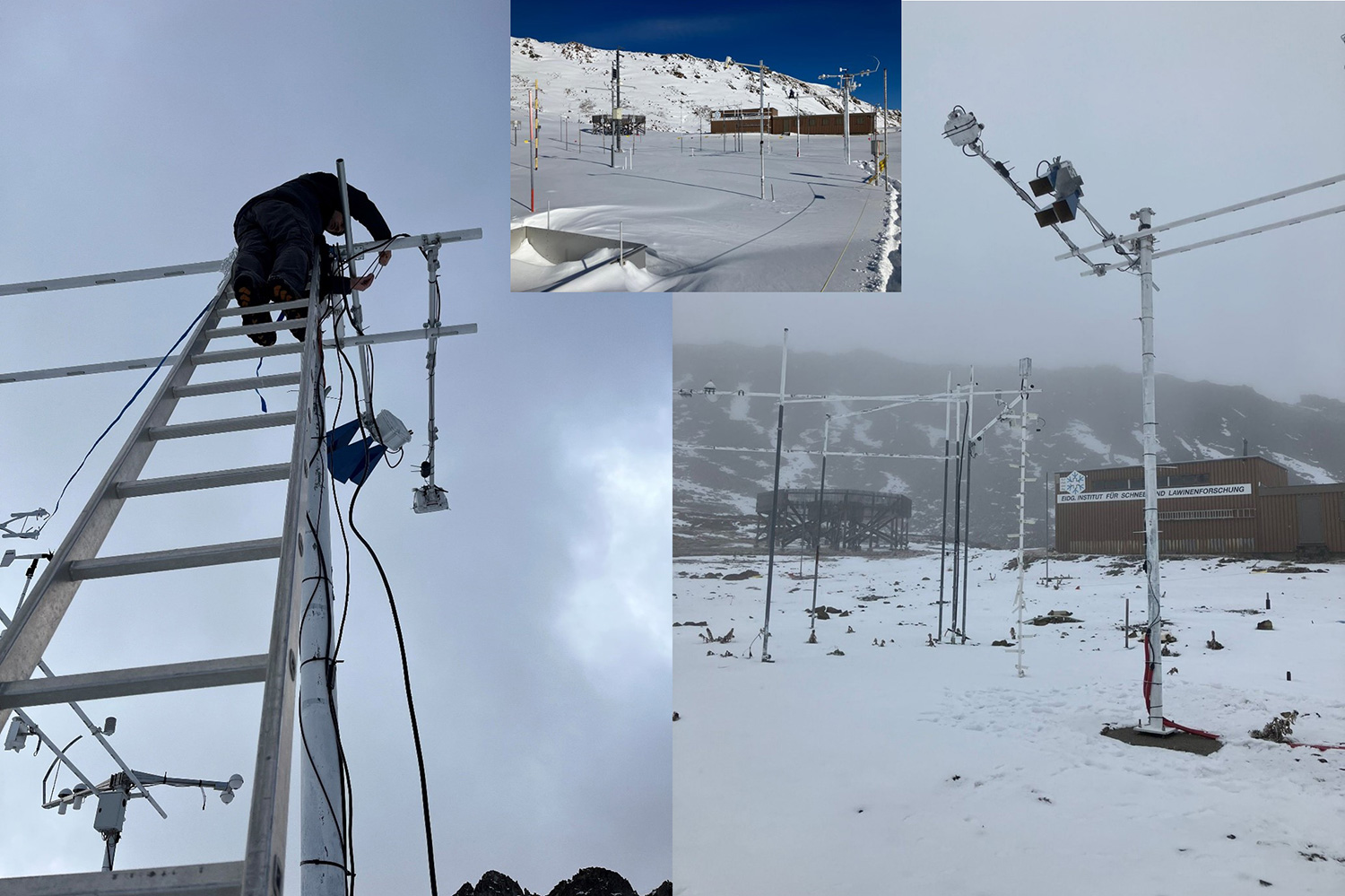
Installation of radars at a new site, namely Weissfluhjoch, near Davos, Switzerland, where snow experiments will take place for Wavetrax. The figures show the testing of two different radar configurations, with different antenna's: the white box contains small linear tapered slot antenna's (LTSA), the blue larger ones are standard gain horn antenna's. The team is currently testing the impact of the antenna's on the measurements, especially because they have a very different footprint (much more focused for the horn antenna's).
Field experiments at 5m height and deep in the snow
End of September 2024, the team of Ghent University’s Hydro-Climate Extremes Lab (H-CEL) installed a new C-band radar sensor atop a 5-meter-high measuring tower at the Weissfluhjoch site in Switzerland. The radar, equipped with standard gain horn antennas, will monitor the backscatter intensity of the snowpack over this years’ snow season.
The data collected will enhance our understanding of backscattering mechanisms affected by various snow properties such as layering, grain size and type, density variations and melting.
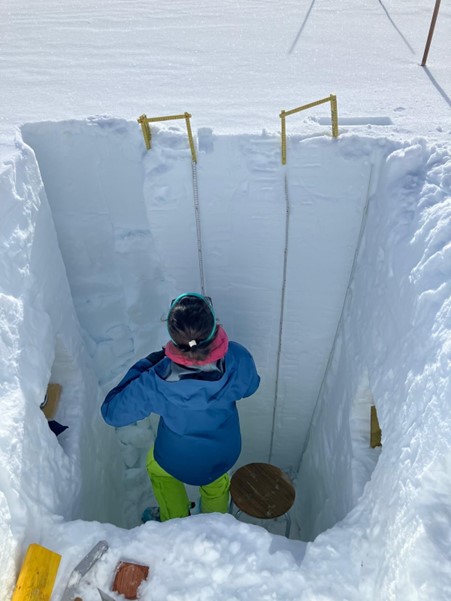
One of the regular snowpit observations at Weissfluhjoch, in February 2024, which the Wavetrax team helped collecting during their site visit.
Project team
Ghent University: Hans Lievens - Niko Verhoest - Diego Miralles - Emma Tronquo - Jaron Vandenbroucke
UC Louvain: Sébastien Lambot - Merlin Mareschal
KU Leuven: Lieven De Strycker - Chesney Buyle - Bert Cox - Guus Leenders - Liesbet van der Perre
Boise State University: Hans-Peter Marshall
TU Delft: Susan Steele-Dunne
Schnee- und Lawinenforschung SLF: Tobias Jonas