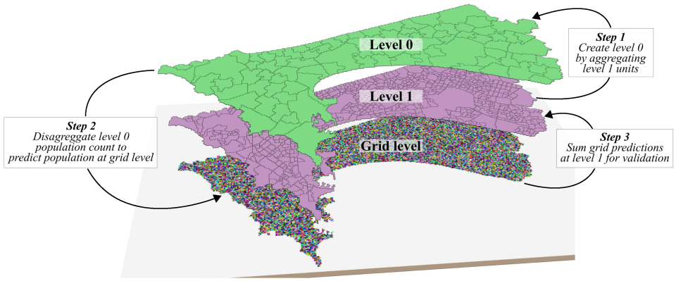
Context and objectives
![]()
![]()
Africa’s population is predicted to double over the next 40 years, driving exceptionally high urban expansion rates. Urbanization has profound social, environmental and epidemiological implications and makes spatial and quantitative estimations of urban change, population density and socio-economic characteristics valuable information for epidemiology and vulnerability assessment. The performance of urban expansion models largely depends on the quality and type of data available. These so far have been limited, which reduced the confidence and the applications of models for Africa. Satellite remote sensing offers an effective solution for mapping settlements and monitoring urbanization at different spatial and temporal scales and allows to link empirical observations with urban theory. Moreover, remote sensing data have a great potential to map and predict intra-urban variations in population density because they provide information on the morphology of different residential patterns that can be linked to different population densities and socio-economic parameters.
The project addresses two specific objectives:
- Produce an urban expansion model at moderate spatial resolution for African cities.
- Understand and predict intra-urban variations in human population density in Africa.

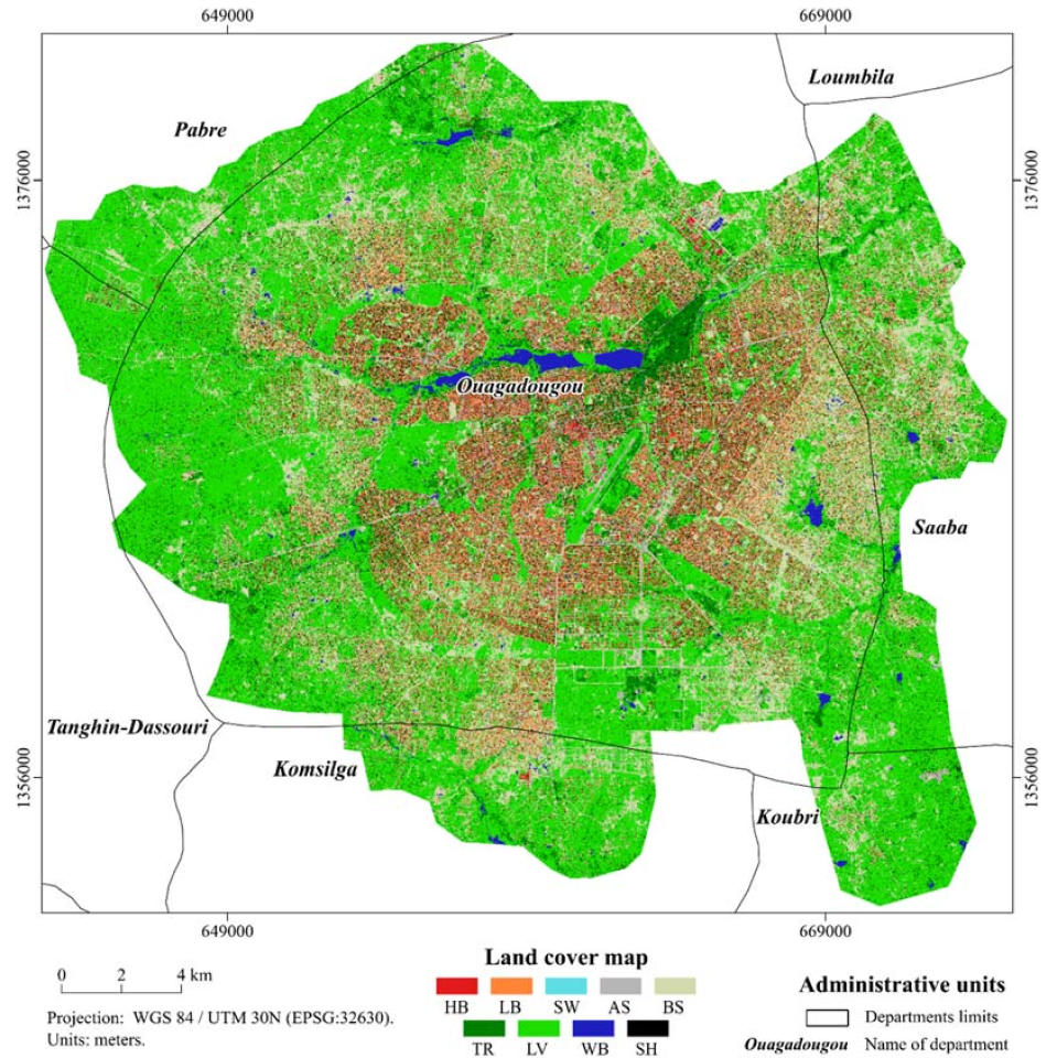
The very-high resolution land-cover map derived from commercial satellite images. Legend classes: HB: High buildings (>10 m); MB: Medium buildings (5–10 m); LB: Low buildings (<5 m); SW: Swimming pools; AS: Artificial ground surfaces; BS: Bare soils; TR: Trees; LV: Low vegetation; WB: Inland waters.
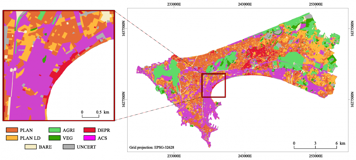
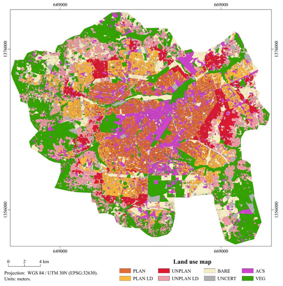
The very-high resolution land-use map derived from the VHR land-cover map. Legend classes: AGRI: Agricultural vegetation; VEG: Natural vegetation; BARE: Bare soils; ACS: Non-residential built-up (administrative, commercial, services, etc.); PLAN: Planned residential built-up; DEPR: Deprived residential built-up.
Project outcome
Results
- Automated methods for urban detection in sub-Saharan Africa, combining different types of remote sensing data.
- Identification of geographical factors that control extension of SSA cities and help to understand their spatial structure.
- Identification of geographical predictors of population densities within cities.
- Identification of the relationships between HRRS and VHRRS landscape attributes.
Products and services
All the methods were developed with a particular focus on automation and transferability. The mapping frameworks and other computer code developed as well as the final maps are made available through different public repositories, at no cost, for anybody and for any purpose:
- Data sets repositories
- Frameworks and computer code: github.com/tgrippa and github.com/yannforget
Potential users
- Researchers and policy makers based in the government ministries and associated organizations of all of the low-income countries to support development, health and planning purposes.
- International organizations and agencies, such as the International Red Cross, World Bank, UN-FAO, UNDP, MSF, Clinton Health Access Initiative, DFID, MapAction.
- Researchers in public health, population health and urban planning.
Outreach
MAUPP - A better understanding of population patterns in sub-Saharan cities and slums
MAUPP - Améliorer la connaissance démographique des villes subsahariennes et de leurs bidonvilles
MAUPP - Inzicht verwerven in bevolkingspatronen in steden en sloppenwijken ten zuiden van de Sahara
| Project leader(s): | ULB - Lutte biologique et Ecologie spatiale (LUBIES) | |||||||
| Belgian partner(s) |
|
|||||||
| International partner(s) |
|
|||||||
| Location: |
Continent:
|
|||||||
| Related presentations: | ||||||||
| Website: | http://maupp.ulb.ac.be | |||||||