Context and objectives
![]()
![]()
Although Earth Observation (EO) offers opportunities to map deprived urban areas (usually known as ‘slums’) and their development over time, most existing studies focus on small areas and use expensive very-high resolution imagery and proprietary solutions. As reported by recent studies using state-of-the-art classification approaches, transferability and generalisation are the key limiting factors.
Therefore, to date, EO has not been used as an effective tool to provide relevant information on deprived areas to public authorities for resource allocation and management. SLUMAP aimed at tackling this issue by taking advantage of low-cost and free-of-charge satellite imagery and geospatial datasets, and by developing open, scalable, automated processes to map the location and extent of deprived areas and to characterise them.
Project outcome
Scientific results
- Our work with stakeholders allowed us to draw conclusions on their requirements and to formulate recommendations to the EO community.
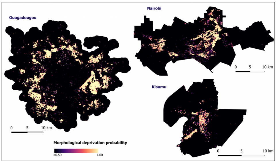
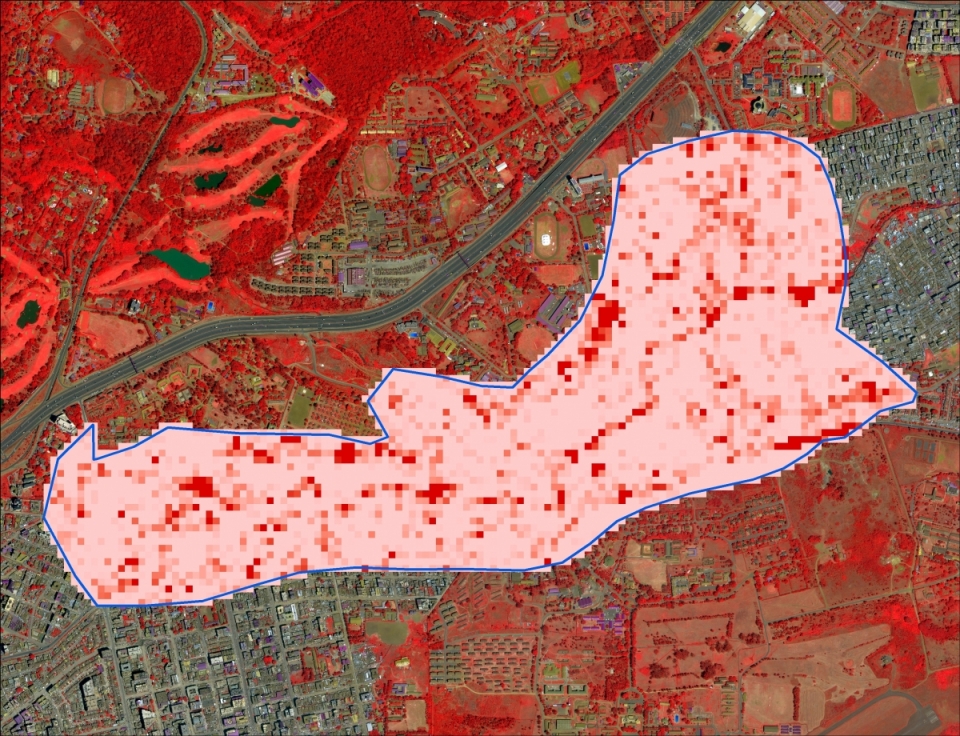
- We developed innovative methods for mapping the morphological deprivation probability at city scale, using publicly available satellite imagery and continental geospatial data. Our methods allow for mapping a wide diversity of deprived urban areas, both within and across cities.
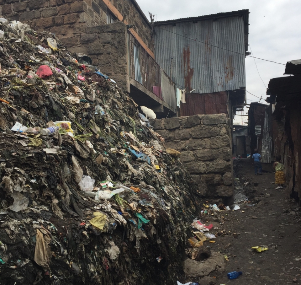
- We demonstrated that, with state-of-the-art feature extraction methods, even baseline VHR EO data (i.e., RGB images) can be used to characterise the urban fabric within deprived areas, leading to parsimonious cost-benefit solutions. We highlighted the potential of rarely mapped urban land-cover classes, such as waste piles and vehicles, to characterise urban deprivation.
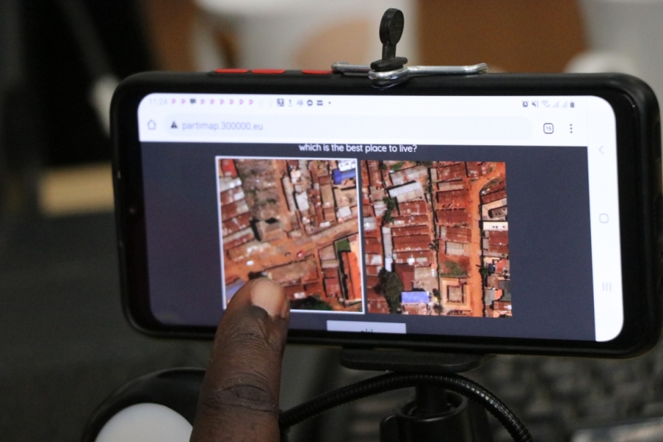
- In the associated DISSUP project PARTIMAP, we identified interpretable spatial indicators that have a strong influence on the perception of deprivation severity by local slum dwellers. We developed methods for extracting them, in view of their usage by authorities and stakeholders.
Societal (including environmental) relevance
The project outcomes will be a valuable input to the further mapping of deprived urban areas in LMICs. With no way to stratify heterogeneous and complex urban areas, data on vulnerable and mobile populations is under-counted in censuses, surveys, and administrative data. When collected, data about the poorest are masked in urban averages. Our ability to map slums, informal settlements, and areas of inadequate housing (SDG 11.1.1) directly impacts our ability to monitor and address local and global development targets including the Sustainable Development Goals: ending poverty (SDG 1), reducing inequality (SDG 10), promoting inclusive and sustainable growth, including full and productive employment (SDG 8), and combating climate change and its impacts (SDG 13).
Products and services
- Citywide morphological deprivation probability maps (i.e., the probability of belonging to a deprived area, considering urban morphology), at 100m x 100m.
- Detailed land-cover maps of deprived areas, with rarely mapped classes (solid waste, vehicles).
- Spatial indicators characterising deprived areas that are useful to policymakers, at 100m x 100m.
- A general framework for identifying and characterizing deprived urban areas in sub-Saharan Africa.
Potential users
Potential users range from international to local stakeholders. International agencies need deprivation maps to disaggregate data for the monitoring of global development targets such as the SDGs. Local and national governments use neighbourhood deprivation maps to move forward the New Urban Agenda, with special attention to vulnerable and deprived communities. This includes improving connectivity, supporting healthy-community initiatives, ensuring the provision of basic services and opportunities for all residents, and mitigating and responding to disasters. Local communities are also likely to use information about local deprivation and assets to improve their own quality of life, including participatory neighbourhood upgrading projects, and advocacy to local authorities for recognition and public services.
Outreach
SLUMAP: Mapping deprived urban areas for pro-poor policies
SLUMAP: achtergestelde stedelijke gebieden in kaart brengen voor armoedebeleid
Cartographier les zones défavorisées

| Project leader(s): | ULB - IGEAT - ANAGEO (Analyse Géospatiale) | |
| Location: |
Continent:
Region:
|
|
| Related presentations: | ||
| Website: | http://slumap.ulb.be/ | |