Publié le 3 novembre 2022
"During what is known as the commissioning phase, EnMAP has delivered first-class images of our planet in outstanding quality," says Walther Pelzer, DLR Executive Board member and head of the German Space Agency at DLR, which is leading the EnMAP mission on behalf of the German Federal Ministry for Economic Affairs and Climate Action (BMWK). "We are pleased to have successfully completed this test phase in October and are now entering routine operations. We can already look forward with great anticipation to what new, exciting scientific insights for the protection of our planet that we will gain from EnMAP data in the coming decades. One area that the EnMAP data will benefit is the sustainable improvement of agricultural yields that will ensure food security for a growing world population."
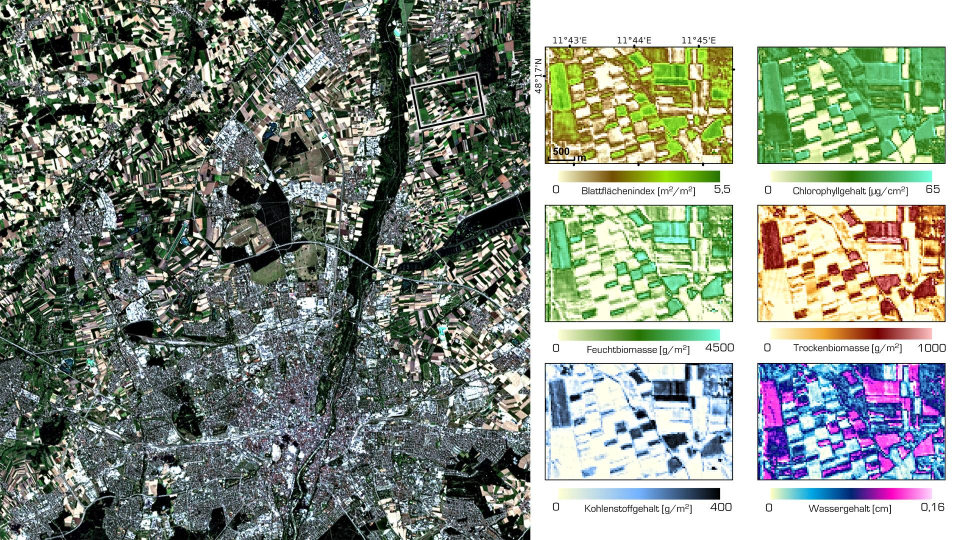
Towards more sustainable agriculture
Credit:EnMAP Commissioning Phase data 2022 DLR/IGGF GEO LMU München
During commissioning, the various components of the EnMAP satellite, including the HSI instrument, had to undergo various tests. During this delicate phase, the German Space Operations Center (GSOC) in Oberpfaffenhofen contributed to the successful completion of commissioning with its many years of experience and will continue to be available for routine operations and – if necessary – provide around-the-clock support to ensure the safety of the satellite. The EnMAP data are received by DLR's German Remote Sensing Data Center (DFD) and Remote Sensing Technology Institute in Oberpfaffenhofen, which also calibrated the images during the commissioning phase, optimised them for the features of the instrument in orbit and, together with the GeoForschungszentrum Potsdam (GFZ), worked to continuously improve the data quality. The data that the satellite sends to Earth cannot be used directly. Only when they are further processed – calibrated, assigned positional data and corrected for atmospheric influences – can users draw quantitative and qualitative conclusions from the products.
From now on, researchers worldwide can submit their requests to DLR. Archived data can be accessed immediately free of charge. A consortium led by the German Space Agency at DLR and GFZ will review the observation requests, which can include the areas of climate change impact, land cover change and surface processes, biodiversity and ecosystem, access to water and water quality, natural resources and disaster management. EnMAP will also provide important data on demand for the 'International Charter Space and Major Disasters' to provide immediate emergency support in the event of a disaster to support relief efforts worldwide. The German Space Agency at DLR places particular importance on the long-term monitoring of environmental change. Consequently, this area of research was given priority during the selection process of future observations beginning at the start of the mission's routine operations phase.
Source:
DLR – EnMAP – Ready for science. (n.d.). DLRARTICLE DLR Portal.